Blaeu, Guiljelmus
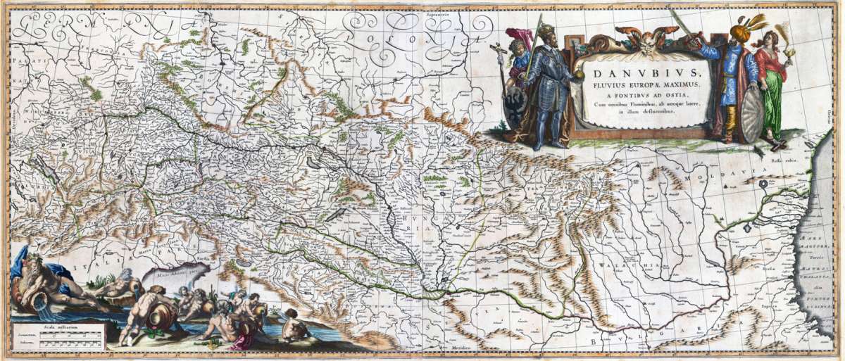
Danubius, Fluvius Europae Maximus, A Fontibus ad ostia. Cum omnibus Fluminibus, ab utroque latere, in illum defluentibus
€950.00
Prices incl. VAT plus shipping costs
This item is sold. Please contact us if you are searching for this item.
Eigenschaften
- Published: Amsterdam
- Published date: 1645
- Type: Antique Map
- Technique: Copper engraving / Original color
- Issue date: 1635-65
- Category: Danube river map
- Size: 410 by 973mm (16¼ by 38¼ inches).
- Bibliography: Koeman II [1110:B2]
- Stock number: 30298
- Condition: The paper with wide margins, overall in excellent condition. Verso blank.
Article description
Article description
Copper engraving, hand colored in outline and wash when published. Published in the atlas by Joan and Guijelmus Blaeu in Amsterdam around 1635-65. A highly decorative map of the river Danube from the its source in the ,Black Forest' towards the mouth of the Danube into the Black Sea. In the upper right corner with a large allegoric title cartouche with the Christian ruler and the ruler of the Turkish empire. The lower left corner with a highly decorative title cartouche with an allegory on the river Danube showing several gods filling water into the source of the river Danube. Many engraved place names, as well river names including neighboring countries as Switzerland, Austria and Bohemia. Printed from two plates, published between 1635 onwards in Blaeu's Theatrum and from 1658 to 1670 in Blaeu's famous ,Atlas Maior'. This example was printed ca. 1645. Verso blank. A large and highly decorative oversized map printed from two plates in old hand color. The map was originally published folded, so that the old folds are still slightly visible.Koeman II [1110:B2]
You might also be interested in the following products
 Palatinatus...
 Copper engraving, hand colored in outline and wash when published. Ornated in the upper right corner with an...
€275.00
 Das Königreich...
 Steel engraving, hand colored in outline when published. Die Karte zeigt das Gebiet von Erfurt im Norden bis...
€35.00
 Bavariae pars...
 Kupferstichkarte, in prachtvollem zeitgenöss. Grenz- u. Flächenkolorit. Dargestellt wird Niederbayern, im Norden...
€295.00
 Bavariae pars...
 Original Kupferstich in zeitgenössischem Grenz- und Flächenkolorit. Original Kupferstichkarte des Nürnberger...
€175.00
Recently viewed products