Moll, Hermann
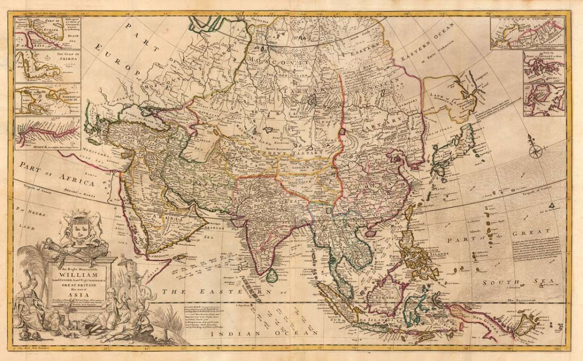
To the Right Honourable William Lord Cowper, Lord High Chancellor of Great Britain This Map of Asia According to ye...
€2,950.00
Prices incl. VAT plus shipping costs
This item is sold. Please contact us if you are searching for this item.
Eigenschaften
- Published: Th. Bowles and John Bowles , London
- Published date: 1708
- Type: Antique Map, map
- Category: Asia
- Technique: Copper engraving / Original color
- Issue date: 1708-26
- Size: 582 by 972mm (23 by 38¼ inches).
- Bibliography: Phillips (Atlases), 554.
- Stock number: 29231
- Condition: The map was printed from two plates. Due to the large size it was often published several folded in Hermann Moll's atlases. Our example is in outstanding excellent condition, which was published plano and has wide margins, too. Overall n excellent condition.
Article description
Article description
Copper engraving, original hand colored in outline when published. This antique map was published in Hermann Moll's atlas ,The World Described, or a New and Correct Sett of Maps ... , in London at J. & T. Bowles circa 1708-26. A highly decorative map of the of the entire Asian continent from the Middle East across Central Asia towards the Far East with Korea and Japan, further including in the southeastern Papua New Guinea. Decorated in the upper corner with seven inset maps: Nova Zembla, the Hellespont, Gulf of Smyrna, the British factories in Chusan and Amoy and the Hugli River. The geographer Hermann Moll came originally from the Netherlands and worked in London in the beginning for Moses Pitt. Later he became one of the important map publishers in England. The atlases, which he published were widely well known. He engraved as well maps for other English publishers (John Seller, etc.).Phillips (Atlases), 554.
You might also be interested in the following products
 Nouvelle...
 Copper-engraving, engraved after or on behalf of Robert de Vaugondy. Published in the geographical supplement of the...
€110.00
 Asiae Nova...
 Original copper engraving, oldcolored, published 1582 in Antwerpen in the atlas "Theatrum Orbis Terrarum". This is...
€2,200.00
 Von den Ländern...
 Woodcut, hand colored in wash. Decorative hand colored woodcut map of the , published in a German text edition of...
€85.00
 Von den Ländern...
 Woodcut, hand colored in wash. Decorative hand colored woodcut map shows a sciene of animals, published in a German...
€85.00
Recently viewed products