Braun, Georg & Hogenberg, Franz
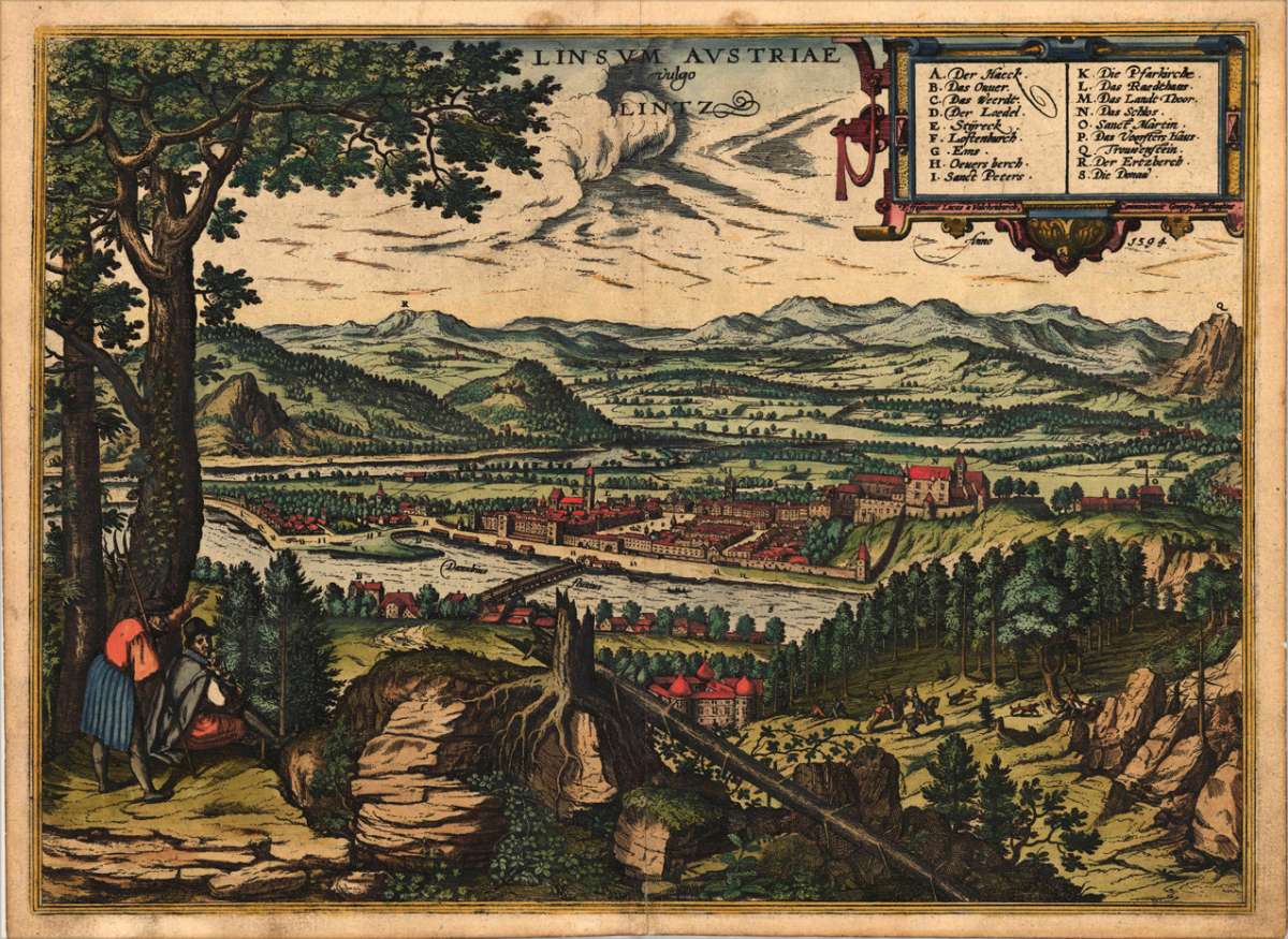
Linzum Austriae vulgo Lintz
€665.00
Prices incl. VAT plus shipping costs
This item is sold. Please contact us if you are searching for this item.
Eigenschaften
- Published: G. Braun & F. Hogenberg , Cologne
- Published date: 1598
- Type: Antique Map, map
- Category: Austria - Österreich
- Issue date: 1598
- Technique: Copper engraving / later handcolor
- Size: 360 by 495mm (14 by 19 inches).
- Bibliography: Koeman, B & H. Vol. V. / 52.
- Stock number: 11552
- Condition: In excellent condition. 360 by 495mm (14 by 19 inches).
Article description
Article description
Original antique hand colored copper engraving, published in volume V of the townbooks "Civitates Orbis Terrarum" by Braun and Hogenberg. The entire series of the 'Civitates Orbis Terrarum' comprised six volumes and was published and printed from 1572 towards 1619 in Cologne. Copper-engraving after a sketch in 1594 by Joris Huefnagel. Decorative view of Linz in Austria from the heights across the river Danube with the city walls, the bridge and its royal castle. J. Huefnagel was a very famous artist, whose sketches of towns are outstanding decorative and were often decorated with figures or local people in the foreground. In the upper right corner with a large decorative renaissance cartouche with explanations. Verso with German text. Georg Braun (also Brunus, Bruin; 1541 – 10 March 1622) was a topo-geographer. From 1572 to 1617 he edited the Civitates orbis terrarum, which contains 546 prospects, bird's-eye views and maps of cities from all around the world. He was the principal editor of the work, he acquired the tables, hired the artists, and wrote the texts. He died as an octogenarian in 1622, as the only survivor of the original team to witness the publication of volume VI in 1617. Braun was born and died in Cologne. His principal profession was as a Catholic cleric. However, he spent thirty-seven years as canon and dean at the church, St. Maria ad Gradus, in Cologne. His six-volume work was inspired by Sebastian Münster's Cosmographia. In form and layout it resembles the 1570 Theatrum orbis terrarum by Abraham Ortelius, as Ortelius was interested in a complementary companion for the Theatrum. The Braun publication set new standards in cartography for over 100 years. Frans Hogenberg (1535–1590, from Mechelen) created the tables for volumes I through IV, and Simon van den Neuwel created those for volumes V and VI. Other contributors were Joris Hoefnagel, Jacob Hoefnagel, cartographer Daniel Freese, and Heinrich Rantzau. Works by Jacob van Deventer, Sebastian Münster, and Johannes Stumpf were also used. Primarily European cities are depicted in the publication; however, Cairo Casablanca and Mexico City as well as Cuzco on one sheet are also included in volume I, whereas Tunis is featured in volume II. Frans Hogenberg (1535–1590) was a Flemish and German painter, engraver, and mapmaker. Hogenberg was born in Mechelen in Flanders as the son of Nicolaas Hogenberg. In 1568 he was banned from Antwerp by the Duke of Alva and travelled to London, where he stayed a few years before emigrating to Cologne. He is known for portraits and topographical views as well as historical allegories. He also produced scenes of contemporary historical events. Hogenberg died in Cologne. (Wikipedia)Koeman, B & H. Vol. V. / 52.
You might also be interested in the following products
 Elegantissimus a...
 Original antique hand colored copper engraving, published in volume V of the townbooks "Civitates Orbis Terrarum" by...
€850.00
 Prospectus...
 Original antiqu copper engraving, uncolored, published in volume V of the townbooks "Civitates Orbis...
€395.00
 Archiducatus...
 Copper-engraving, handcolored in wash and outline when published. A strong impression. Decorative map of the...
€340.00
 Austriae Descrip....
 Original antique copper engraving, published 1598 in a French text edition of the 'Theatrum Orbis...
€480.00
Recently viewed products