Diewald, I. N.
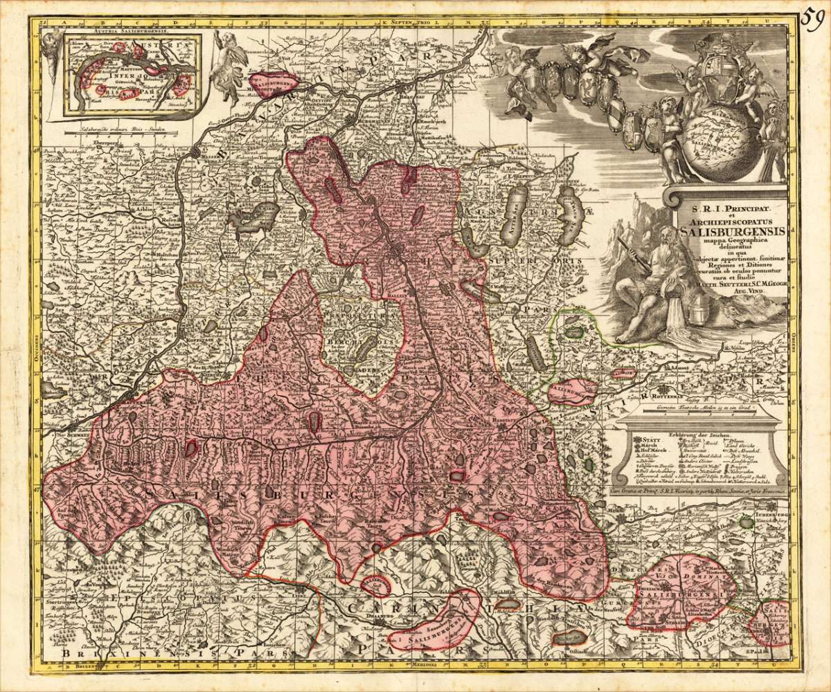
Das Chur-Fürstenthum Salzburg samt den dazu gehörigen Fürstenthümern Passau, Aichstaedt und Berchtesgaden, dan den...


€445.00
Prices incl. VAT plus shipping costs
This item is sold. Please contact us if you are searching for this item.
Eigenschaften
- Published: Nürnberg
- Published date: 1720
- Issue date: 1803
- Technique: Kupferstich, original Kolorit.
- Type: map
- Category: Electorate of Salzburg
- Size: 515 by 500mm (20¼ by 19¾ inches).
- Stock number: 16617
- Condition: In ausgezeichnetem Erhaltungszustand.
Article description
Article description
Original Kupferstichkarte, in zeitgenössischem Grenz- und Flächenkolorit. Dargestellt wird das Kurfürstentum Salzburg von dem Kartographen Johann Nepumuk Diewald (1774-1830) um 1803 mit seinen dazugehörigen Fürstentümern Passau, Eichstätt und Berchtesgaden. Äußerst detaillierte Kupferstichkarte mit vielen detaillierten Ortsangaben, Flüßen und Seen, Bergen, Gebirgspässe, Postwegen, Festungen, etc. Dazu mit drei kleinen ausführlichen Legenden im Unterrand der Karte. Im oberen Teil des Kartenbildes mit drei Insetkarten: ,Das Bisthum Aichstaedt', ,Passau' und ,im Lande unter der Ens'. - The Electorate of Salzburg is represented by the cartographer Johann Nepumuk Diewald around 1803 with its associated principalities Passau, Eichstätt and Berchtesgaden. Very detailed copper engraved map with many detailed place names, rivers and lakes, mountains, mountain passes, post offices, fortresses, etc. In addition, with three small detailed inset maps at the lower bottom of the map. In the upper part of this historic map three inset maps: 'The Bisthum Aichstaedt', 'Passau' and ,im Lande unter der Ens'. Johann Nepumuk Diewald (1774-1830) was an active cartographer in Nürnberg, close to thirty maps of him were published between 1803 and 1854, many of them with the publishers house ,Homann Heirs' in Nürnberg, further he also published maps with Gottlieb Weigel in Nürnberg around the same period.You might also be interested in the following products
 Elegantissimus a...
 Original antique hand colored copper engraving, published in volume V of the townbooks "Civitates Orbis Terrarum" by...
€850.00
 Prospectus...
 Original antiqu copper engraving, uncolored, published in volume V of the townbooks "Civitates Orbis...
€395.00
 Archiducatus...
 Copper-engraving, handcolored in wash and outline when published. A strong impression. Decorative map of the...
€340.00
 Austriae Descrip....
 Original antique copper engraving, published 1598 in a French text edition of the 'Theatrum Orbis...
€480.00
Recently viewed products