Geyer, V.
Nieder- und Ober-Oesterreich oder das Erzherzogthum Oesterreich unter & ob der Enns und das Herzogthum Salzburg
€90.00
Prices incl. VAT plus shipping costs
This item is sold. Please contact us if you are searching for this item.
Eigenschaften
- Published: Weimar
- Published date: 1870
- Technique: Copperengraving/handcolored., Copper engraving / hand colored.
- Category: Austria
- Type: map
- Issue date: ca. 1870
- Size: 490 by 650mm (19¼ by 25½ inches).
- Stock number: 30528
- Condition: In excellent condition.
Article description
Article description
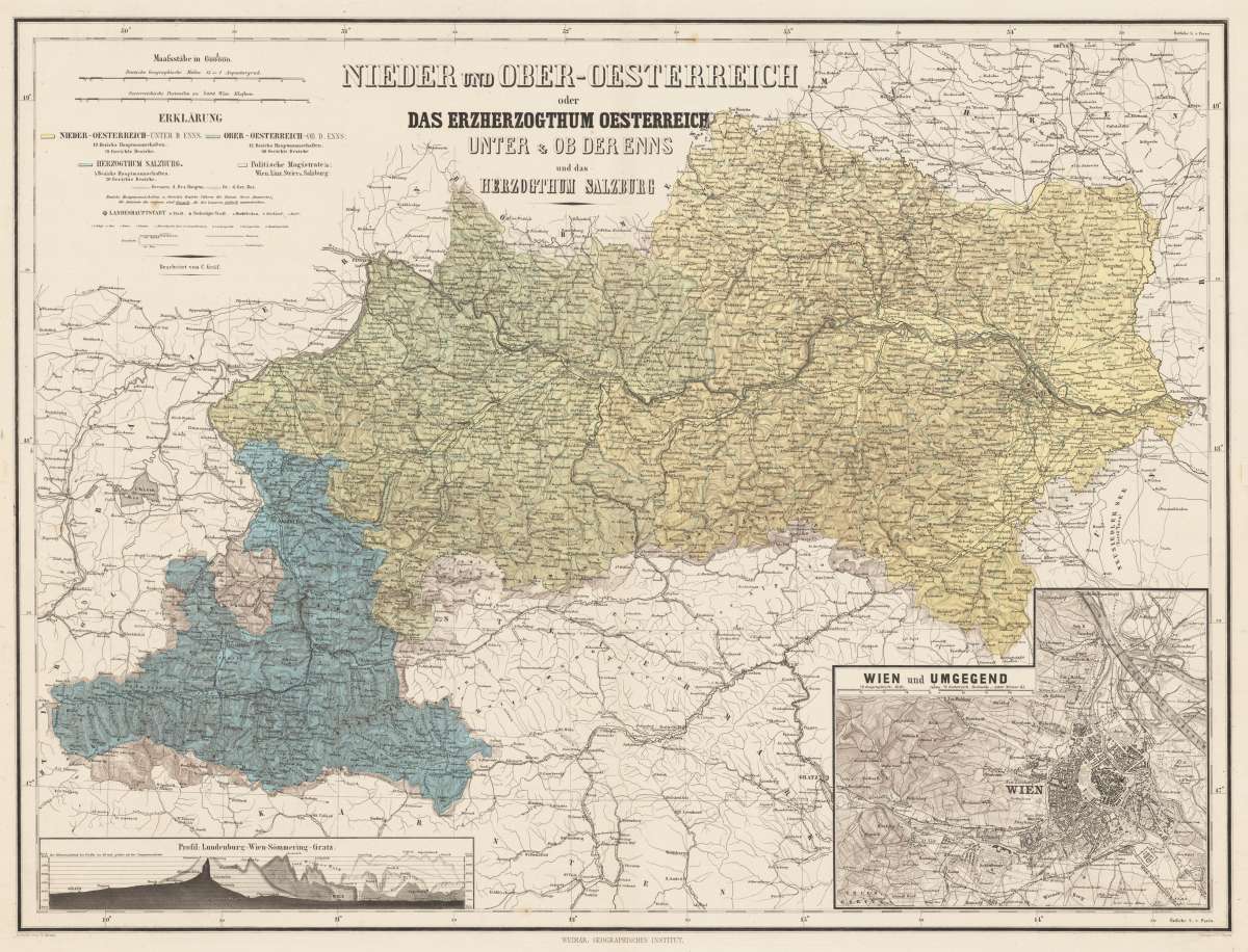
Original Kupferstich in zeitgenössischem Flächenkolorit. Bearbeitet von C. Gräf. Diese antike Landkarte zeigt das Gebiet zwischen Brünn im Norden und Feldkirchen im Süden, sowie Pressburg im Osten und Rosenheim im Westen. Oben mittig ist der Titel eingraviert und links daneben zwei Meilenzeiger (Deutsche Geographische Meilen und Österreichische Postmeilen) und die farbliche Erklärung zu Kreisen und Bezirksgrenzen der Landkarte. In der rechten unteren Ecke ist eine Insetkarte von Wien und Umgebung. Auf der linken Seite ist das Bergprofil von Lundenburg, Wien, Sömmering und Gratz. Unterhalb der Darstellung links der Vermerk: "Schrift von W. Kratz", in der Mitte Angabe "Weimar: Geographisches Institut." sowie "Terrain v.V. Geyer." Original copper engraving hand colored in outline when published. Edited by C. Gräf. This ancient map shows the area between Brünn in the north and Feldkirchen in the south, as well as Pressburg in the east and Rosenheim in the west. The title is engraved in the upper center and two mileage scales (German Geographical Miles and Austrian Post Miles) and the colored explanation on circles and district boundaries of the map. In the lower right corner is an inset map of Vienna and the surrounding area. On the left side is the mountain profile of Lundenburg, Vienna, Sömmering and Gratz. Below the illustration on the left is the note: "Schrift von W. Kratz", in the middle "Weimar: Geographisches Institut." as well as "Terrain v.V. Geyer."You might also be interested in the following products
 Elegantissimus a...
 Original antique hand colored copper engraving, published in volume V of the townbooks "Civitates Orbis Terrarum" by...
€850.00
 Prospectus...
 Original antiqu copper engraving, uncolored, published in volume V of the townbooks "Civitates Orbis...
€395.00
 Archiducatus...
 Copper-engraving, handcolored in wash and outline when published. A strong impression. Decorative map of the...
€340.00
 Austriae Descrip....
 Original antique copper engraving, published 1598 in a French text edition of the 'Theatrum Orbis...
€480.00
Recently viewed products