Ortelius, Abraham
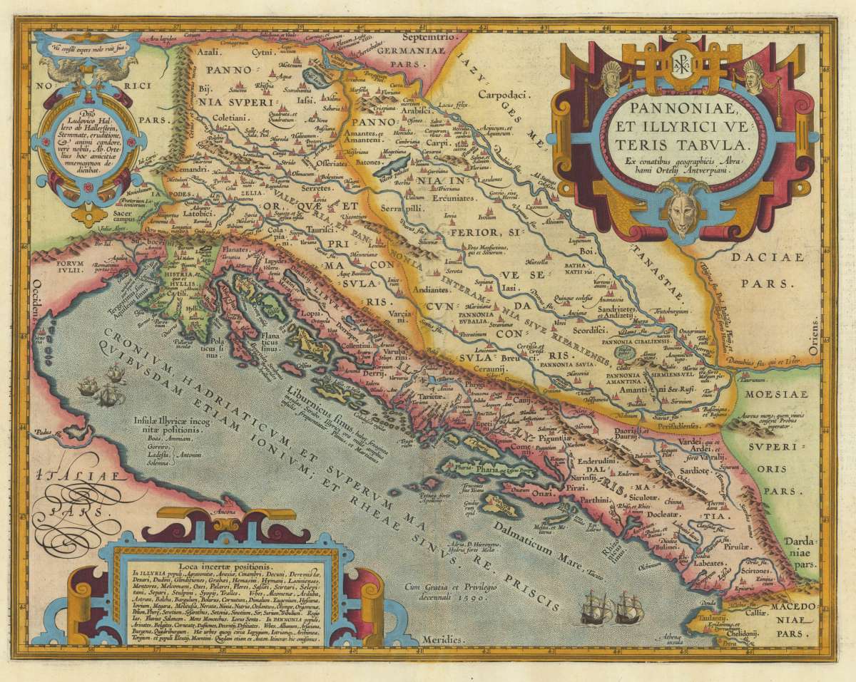
Pannoniae et Illyrici Veteris Tabula. Ex conatibus geographicis Abrahami Ortelii Antverpiani.
€695.00
Prices incl. VAT plus shipping costs
This item is sold. Please contact us if you are searching for this item.
Eigenschaften
- Published: Antwerp
- Published date: 1612
- Type: Antique Map, map
- Issue date: 1612
- Technique: Copper engraving / later hand colored.
- Category: Illyria
- Size: 355 by 455mm (14 by 18 inches).
- Bibliography: Koe. Ort. 46; Broe. 203.
- Stock number: 30972
- Condition: In excellent condition.
Article description
Article description
Original antique copper engraving, published 1612 in the famous historical Atlas "Parergon" (Latin text-edition) by Abraham Ortelius. Finely later hand-colored in wash and outline. Abraham Ortelius's beautiful map of the Adriatic Sea with its neighbouring countries Croatia, Slovenia, Serbia, Montenegro, Albania and the northern part of Macedonia. The Adriatic coastline is well engraved with islands, place names and rivers towards the sea. Decorated with sailing ships in the sea. The antique map is equipped with three renaissance cartouches with descriptive text. Ortelius was born on 14 April 1527 in the city of Antwerp, which was then in the Habsburg Netherlands (modern-day Belgium). The Orthellius family were originally from Augsburg, a Free imperial city of the Holy Roman Empire. In 1535, the family had fallen under suspicion of Protestantism. Following the death of Ortelius's father, his uncle Jacobus van Meteren returned from religious exile in England to take care of Ortelius. Abraham remained close to his cousin Emanuel van Meteren, who would later move to London. In 1575 he was appointed geographer to the king of Spain, Philip II, on the recommendation of Arias Montanus, who vouched for his orthodoxy. He travelled extensively in Europe and is specifically known to have traveled throughout the Seventeen Provinces; in southern, western, northern, and eastern Germany (e.g., 1560, 1575–1576); France (1559–1560); England and Ireland (1576); and Italy (1578, and perhaps twice or thrice between 1550 and 1558). Beginning as a map-engraver, in 1547 he entered the Antwerp Guild of Saint Luke as an illuminator of maps. He supplemented his income trading in books, prints, and maps, and his journeys included yearly visits to the Frankfurt book and print fair, where he met Gerardus Mercator in 1554. In 1560, however, when travelling with Mercator to Trier, Lorraine, and Poitiers, he seems to have been attracted, largely by Mercator's influence, towards the career of a scientific geographer. (Wikipedia)Koe. Ort. 46; Broe. 203.
You might also be interested in the following products
 Rhetiae alpestris...
 Original copper engraving, published 1612 in the famous Vrients-edition of the "Theatrum Orbis Terrarum"....
€440.00
 Carinthiae...
 Original copper engraving, published 1598 in a French edition of the "Theatrum Orbis Terrarum". Finely...
€495.00
 Koenigreich...
 Original antique copper engraving, hand colored in outline and wash, when published. This decorative map shows the...
€295.00

Recently viewed products