Homann, J.B. (Homann Heirs)
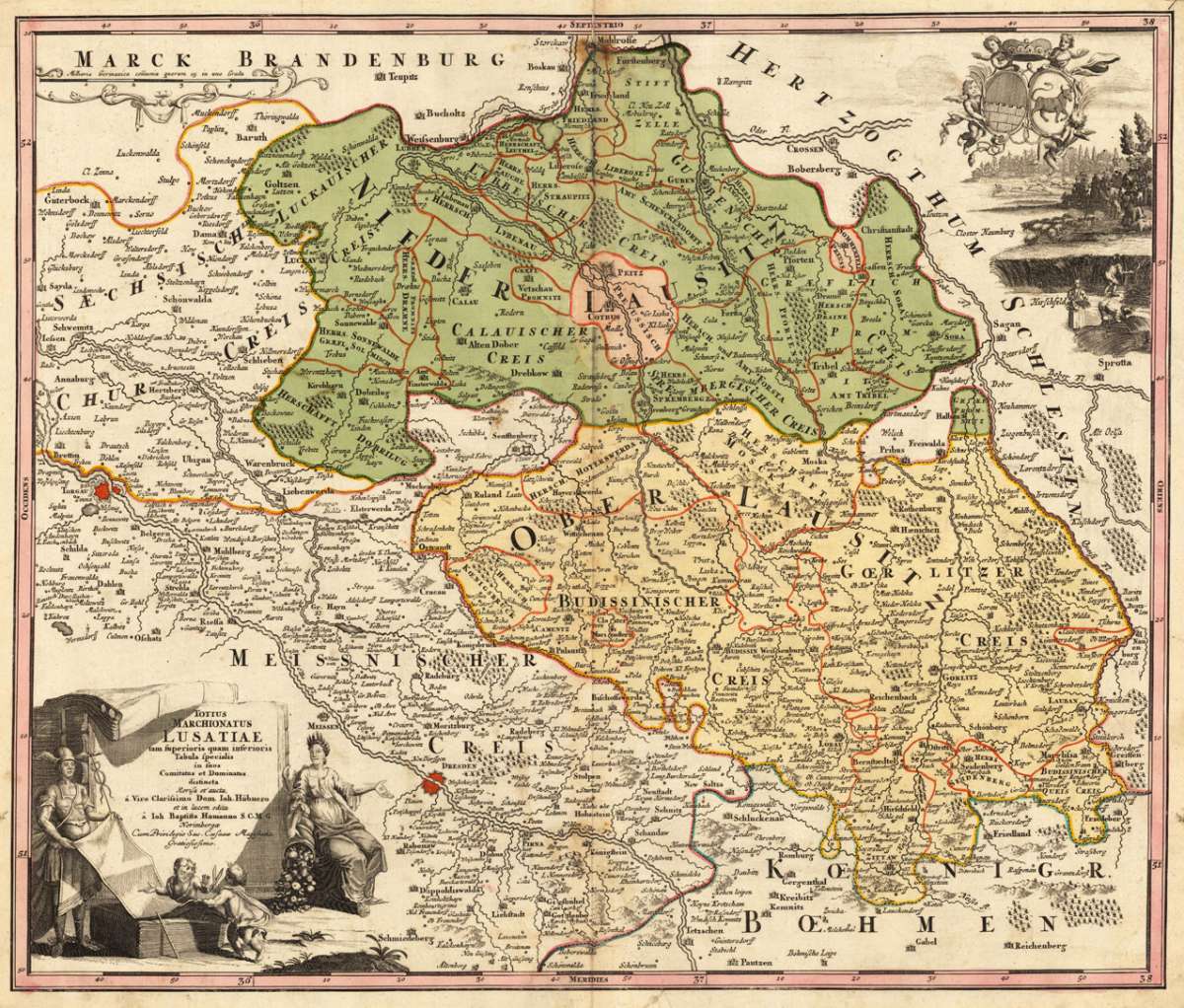
Totius Marchionatus Lusatiae tam superioris quam interioris Tabula specialis in suos Comitatus et Dominatus distineta...
€345.00
Prices incl. VAT plus shipping costs
This item is sold. Please contact us if you are searching for this item.
Eigenschaften
- Published: J. B. Homann , Nürnberg
- Published date: 1720
- Technique: Copper engraving / Original color.
- Type: Antique Map, map
- Issue date: 1720
- Category: Lausnitz with Görlitz in Silesia
- Size: 482 by 572mm (19 by 22 inches).
- Stock number: 29798
- Condition: Overall in very good to excellent condition. A minor marginal tear, slightly affecting the image of lower engraved border line, verso mended with paper. 482 by 572mm (19 by 22 inches).
Article description
Article description
Original antique copper engraving, hand colored in outline and wash, when published. Diese dekorative Karte zeigt die Lausitz mit Teilen von Schlesien und Görlitz. In der unteren linken Ecke finden wir die bildliche Titelkartusche mit Winkeln. In der oberen rechten Ecke sehen wir eine Landschaftsansicht mit Winkeln, die das Wappen der Lausitz halten. Die Karte ist mit vielen detaillierten kleinen Ortsnamen, Flüssen, Bergen, Wäldern usw. Ausgestattet. Copper engraving, hand colored in outline and wash. This decorative map shows the Lausitz with parts of Silesia and Görlitz. In the lower left corner we find the figurative title cartouche with angles. In the upper right corner we look at a landscape view with angles holding the coats of arms of the Lausitz. The map is equipped with many detailed small place names, rivers, mountains, woods,etc. Johann Baptist Homann (20 March 1664 – 1 July 1724) was a German geographer and cartographer, who also made maps of the Americas. Homann was born in Oberkammlach near Kammlach in the Electorate of Bavaria. Although educated at a Jesuit school, and preparing for an ecclesiastical career, he eventually converted to Protestantism and from 1687 worked as a civil law notary in Nuremberg. He soon turned to engraving and cartography; in 1702 he founded his own publishing house. Homann acquired renown as a leading German cartographer, and in 1715 was appointed Imperial Geographer by Emperor Charles VI. Giving such privileges to individuals was an added right that the Holy Roman Emperor enjoyed. In the same year he was also named a member of the Prussian Academy of Sciences in Berlin. Of particular significance to cartography were the imperial printing privileges (Latin: privilegia impressoria). These protected for a time the authors in all scientific fields such as printers, copper engravers, map makers and publishers. They were also very important as a recommendation for potential customers. In 1716 Homann published his masterpiece Grosser Atlas ueber die ganze Welt (Grand Atlas of all the World). Numerous maps were drawn up in cooperation with the engraver Christoph Weigel the Elder, who also published Siebmachers Wappenbuch. Homann died in Nuremberg in 1724. He was succeeded by his son Johann Christoph (1703-1730). The company carried on upon his death as Homann heirs company, managed by Johann Michael Franz and Johann Georg Ebersberger. After subsequent changes in management the company folded in 1852.[1] The company was known as "Homann Erben", "Homanniani Heredes", or "Heritiers de Homann" abroad. (Wikipedia)You might also be interested in the following products
 Der Königlichen...
 Original copper engraving, hand colored in wash and outline, when published. Detailed map showing the Woiwodschaft...
€95.00
 Der königlichen...
 Original copper engraving, hand colored in wash and outline, when published. The Austrian cartographer Franz...
€145.00
 Der Fall eine...
 Original antique copper engraving, uncolored as published. Decorative engraving of the city of Navra in Poland,...
€75.00
 Narva von der...
 Original antique copper engraving, uncolored as published. Decorative panoramic view of the polish city Narva. This...
€195.00
Recently viewed products