Braun, Georg & Hogenberg, Franz
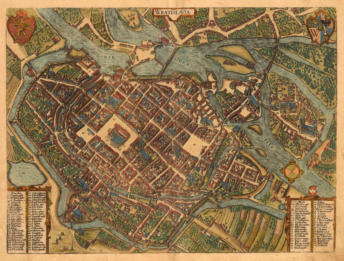
Wratislavia
Prices incl. VAT plus shipping costs
This item is sold. Please contact us if you are searching for this item.
- Published: Cologne
- Published date: 1587
- Technique: Copper engraving / later hand color
- Issue date: 1587-90
- Category: Wratislava Breslau
- Type: map
- Size: 363 by 487mm (14 by 19 inches).
- Stock number: 30022
- Condition: At the lower centerfold is a small mending slightly visible else in very good condition. German text edition verso.
Article description
Original copper-engraving, handcolored in wash, published circa 1587/90 in the townbook Civitates Orbis Terrarum by Braun and Hogenberg. Verso with Gereman text. The entire series of the 'Civitates Orbis Terrarum' comprised six volumes and was published and printed from 1572 towards 1619. Decorative bird's eye view of the city Wratislava (Breslau) in Poland. This decorative and accurate plan of the city of Wratislava is ornated with coat of arms in the upper corners. In the lower corners we find two tables with 91 explanations on buildings, churches, markets, mills, gates and other places. The map is as well equipped with a compass rose. The city is very well shown with all the islands in the Oder river, as well with its walls and the gardens and fields around it. Georg Braun (also Brunus, Bruin; 1541 – 10 March 1622) was a topo-geographer. From 1572 to 1617 he edited the Civitates orbis terrarum, which contains 546 prospects, bird's-eye views and maps of cities from all around the world. He was the principal editor of the work, he acquired the tables, hired the artists, and wrote the texts. He died as an octogenarian in 1622, as the only survivor of the original team to witness the publication of volume VI in 1617. Braun was born and died in Cologne. His principal profession was as a Catholic cleric. However, he spent thirty-seven years as canon and dean at the church, St. Maria ad Gradus, in Cologne. His six-volume work was inspired by Sebastian Münster's Cosmographia. In form and layout it resembles the 1570 Theatrum orbis terrarum by Abraham Ortelius, as Ortelius was interested in a complementary companion for the Theatrum. The Braun publication set new standards in cartography for over 100 years. Frans Hogenberg (1535–1590, from Mechelen) created the tables for volumes I through IV, and Simon van den Neuwel created those for volumes V and VI. Other contributors were Joris Hoefnagel, Jacob Hoefnagel, cartographer Daniel Freese, and Heinrich Rantzau. Works by Jacob van Deventer, Sebastian Münster, and Johannes Stumpf were also used. Primarily European cities are depicted in the publication; however, Cairo Casablanca and Mexico City as well as Cuzco on one sheet are also included in volume I, whereas Tunis is featured in volume II. Frans Hogenberg (1535–1590) was a Flemish and German painter, engraver, and mapmaker. Hogenberg was born in Mechelen in Flanders as the son of Nicolaas Hogenberg. In 1568 he was banned from Antwerp by the Duke of Alva and travelled to London, where he stayed a few years before emigrating to Cologne. He is known for portraits and topographical views as well as historical allegories. He also produced scenes of contemporary historical events. Hogenberg died in Cologne. (Wikipedia)
You might also be interested in the following products
 Der Königlichen...
  Der königlichen...
  Der Fall eine...
  Narva von der...