Petermann, A.
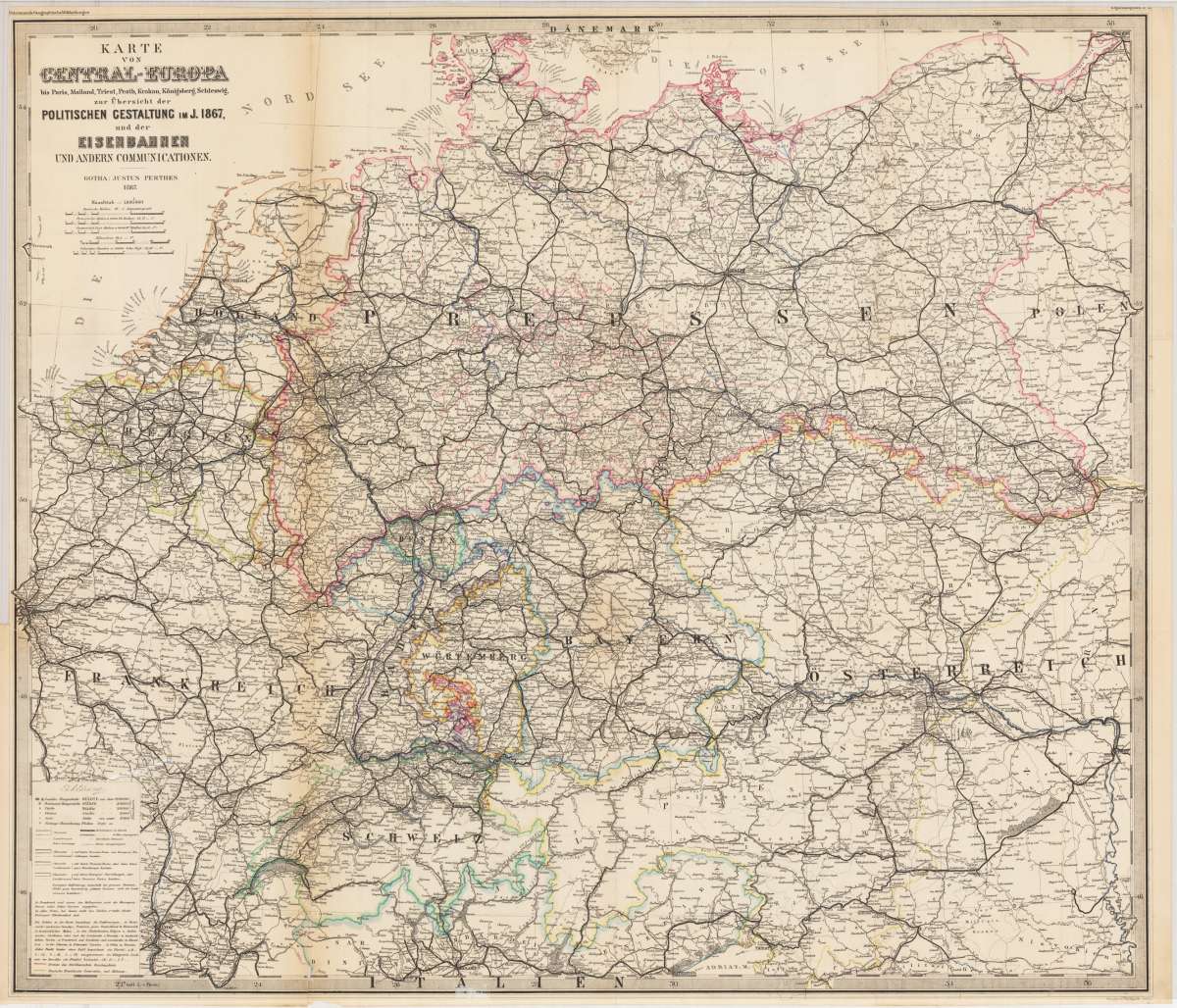
Karte von Central-Europa bis Paris, Mailand, Triest, Pesth, Krakau, Königsberg, Schleswig, zur Übersicht der...
Petermann, A. – Central Europe · Lithograph, Printed in Colours · Petermanns Geographische Mitteilungen, Gotha · 1867
Eigenschaften
- Published: Gotha
- Published date: 1867
- Technique: Lithograph / Original color
- Issue date: 1867
- Type: map
- Category: Central-Europa
- Size: 61 x 71 cm (24 x 28 inches).
- Stock number: 26786
- Condition: The map was originally published folded, so that the old folds are still slightly visible. On the backside are some repairs slightly visible. The paper is very sensitive.
Article description
Article description
Original antique lithograph, printed in colours, published by Justus Perthes in Gotha for 'Petermanns Geographische Mitteilungen', 1867. Lithograph, original color in outline and wash. Sheet: 61 x 71 cm (24 x 28 inches).. August Heinrich Petermann (1822–1878) was one of the most important German cartographers and geographers of the 19th century. Born in Bleicherode, Saxony, he trained at the Geographische Kunstschule in Potsdam under Heinrich Berghaus — himself a leading student of Alexander von Humboldt. After a formative decade in Edinburgh and London (1845–1854), where he gained broad experience in the commercial and scientific aspects of cartography, Petermann returned to Gotha and joined the Justus Perthes publishing house. In 1855 he founded 'Petermanns Geographische Mitteilungen' (PGM), which swiftly became one of the world's foremost geographical journals — the definitive record of the great age of exploration and discovery. Petermann personally produced over 500 maps and signed 226 articles in PGM, ranging across Africa, the Polar regions, Asia, and the history and practice of cartography. In 1902, the eminent British cartographer J. G. Bartholomew wrote: 'No one has done more than he to advance modern cartography.' His maps are held in major institutions worldwide, including the Library of Congress, the British Library, and the Bibliothèque nationale de France. Shows all railway lines from 1867. The map was created after the German-Danish War 1864 to 1866. One of the last maps before the Franco-German War and the establishment of the German Empire. The map was originally published folded, so that the old folds are still slightly visible. On the backside are some repairs slightly visible. The paper is very sensitive.Petermann, A. – Central Europe · Lithograph, Printed in Colours · Petermanns Geographische Mitteilungen, Gotha · 1867
You might also be interested in the following products
 Carte D' Europe.
 Original copper engraving with hand-applied outline color, by engraver Blondeau, published by the celebrated French...
€110.00
 Romania Imperii...
 Original copper engraving of the Eastern Roman Empire after the geographic text of Michel'Antoine Baudrand,...
€295.00
 Geographia...
 Rare and decorative large-format historical map of Europe showing the locations of Church Councils and Synods, in...
€322.43
 Karte der...
 Original color lithograph mapping the main seismic impact zones in Central Europe, by the renowned German...
€25.00
Recently viewed products