Petermann, A.
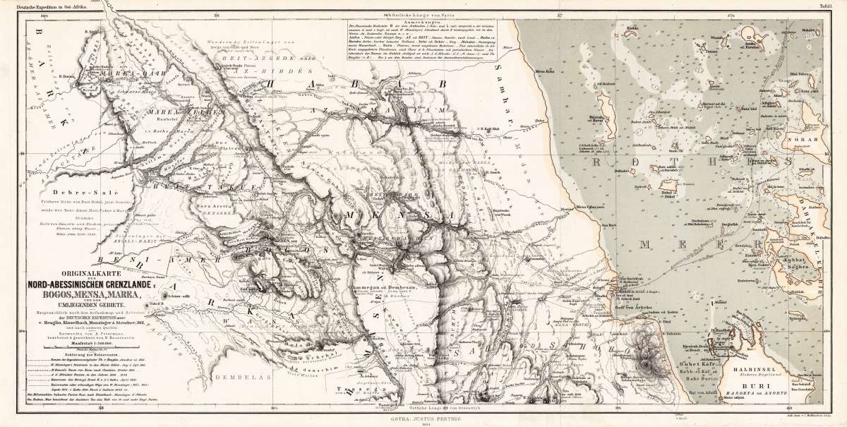
Originalkarte der Nord-Abessinischen Grenzlande - Bogos, Mensa, Marea, und der umliegenden Gebiete. - Hauptsächlich...
Petermann, A. – North Abyssinia Border Regions · Lithograph, Hand Coloured · Petermanns Geographische Mitteilungen, Gotha · 1864
Eigenschaften
- Published: Justus Perthes. , Gotha
- Published date: 1864
- Type: Antique Map, map
- Technique: Lithograph / Original color.
- Issue date: 1864
- Category: North Abyssinia & Red Sea
- Size: 250 by 507mm (9¾ by 20 inches).
- Stock number: 23535
- Condition: In excellent condition. The map was originally folded, so that the old folds are still slightly visible. 250 by 507mm (9¾ by 20 inches).
Article description
Article description
Original antique lithograph, hand coloured, published by Justus Perthes in Gotha for 'Petermanns Geographische Mitteilungen', 1864. Original lithograph, hand colored in outline and wash when published. Sheet: 250 by 507mm (9¾ by 20 inches).. August Heinrich Petermann (1822–1878) was one of the most important German cartographers and geographers of the 19th century. Born in Bleicherode, Saxony, he trained at the Geographische Kunstschule in Potsdam under Heinrich Berghaus — himself a leading student of Alexander von Humboldt. After a formative decade in Edinburgh and London (1845–1854), where he gained broad experience in the commercial and scientific aspects of cartography, Petermann returned to Gotha and joined the Justus Perthes publishing house. In 1855 he founded 'Petermanns Geographische Mitteilungen' (PGM), which swiftly became one of the world's foremost geographical journals — the definitive record of the great age of exploration and discovery. Petermann personally produced over 500 maps and signed 226 articles in PGM, ranging across Africa, the Polar regions, Asia, and the history and practice of cartography. In 1902, the eminent British cartographer J. G. Bartholomew wrote: 'No one has done more than he to advance modern cartography.' His maps are held in major institutions worldwide, including the Library of Congress, the British Library, and the Bibliothèque nationale de France. Map of the regions to the North-Abessinian borders near Bogos, Mensa and Marea, drawn after the mapping by Heuglin, Kinzelbach, Munzinger & Steudner in 1861. As well the map shows detailed a part of the Red Sea with the peninsula of Buri, the islands of Norah, Dahlak-el-Kebir and many other small islands. Detailed information on the depths in the Red Sea bare as well provided. In excellent condition. The map was originally folded, so that the old folds are still slightly visible.Petermann, A. – North Abyssinia Border Regions · Lithograph, Hand Coloured · Petermanns Geographische Mitteilungen, Gotha · 1864
You might also be interested in the following products


 Keyserlyk...
 Original copper engraving, uncoloured as published. The famous Dutch publisher and mapmaker Pieter Van der Aa...
€175.00
 Die Stadt...
 Copper engraving, hand colored in wash and outline, published in Allain Manesson Mallet's description of the world.
€60.00
Recently viewed products