Renard, Louis
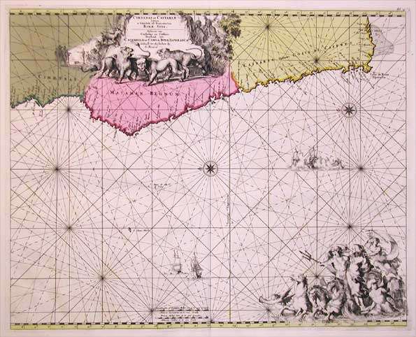
Cimbebas et Caffariae Littora a Catenbela ad Promontorium Bonae Spei. Pascaerte van Cimbebas en Caffares Streckende...
Eigenschaften
- Published: Louis Renard , Amsterdam
- Published date: 1700
- Technique: Copper engraving / Original color.
- Type: Antique Map, map
- Category: South Africa
- Issue date: 1700
- Size: 430 by 535mm (17 by 21 inches).
- Stock number: 14955
- Condition: 430 by 535mm (17 by 21 inches).
Article description
Article description
Copper-engraving, hand colored in outline and wash when published. Large and decorative sea chart showing West Africa with the Canary and Cap Verden Island in the Atlantic Ocean. Published around 1700 in Louis Renard's famous sea-atlas. An execellent copy of this rare map.
You might also be interested in the following products
 Etats du Roi de...
 Original antique copper engraving, uncolored as published. Two interesting maps of North Africa on 1 double page...
€80.00
 Neueste Karte von...
 Steel engraving, in original colors, as published. A detailed map of Tunisia with many place names inland and along...
€80.00
 Neueste Karte von...
 Steel engraving, in original colors, as published. A detailed map of Nubia and Habesch with the Red Sea.
€60.00
 Pascaert van de...
 Original antique copper engraving, uncolored as published. Johannes van Keulen (1654 in Deventer – 1715 in...
€850.00
Recently viewed products