Petermann, A.
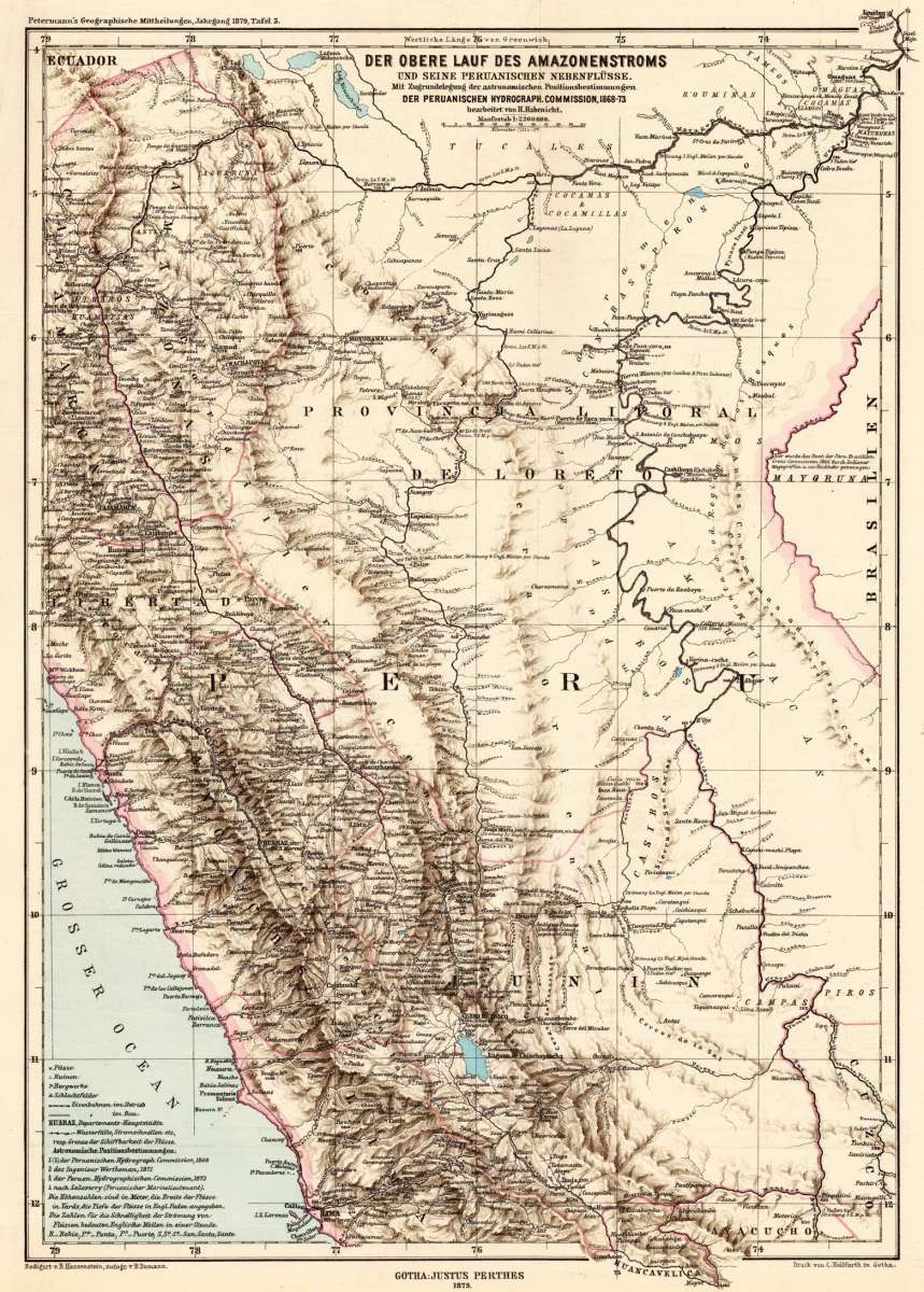
Der obere Lauf des Amazonenstroms und seine peruanischen Nebenflüsse. Mit Zugrundelegung der astronomischen...
Petermann, A. – Amazon River · Lithograph, Printed in Colours · Petermanns Geographische Mitteilungen, Gotha · 1879
Eigenschaften
- Published: Justus Perthes. , Gotha
- Published date: 1879
- Type: Antique Map, map
- Technique: Lithograph / Original color.
- Issue date: 1879
- Category: Amazonas
- Size: 430 by 306mm (17 by 12 inches).
- Stock number: 26545
- Condition: In excellent condition. The map was originally published folded, so that the old folds are still slightly visible. 430 by 306mm (17 by 12 inches).
Article description
Article description
Original antique lithograph, printed in colours, published by Justus Perthes in Gotha for 'Petermanns Geographische Mitteilungen', 1879. Lithograph, original color as published. Sheet: 430 by 306mm (17 by 12 inches).. August Heinrich Petermann (1822–1878) was one of the most important German cartographers and geographers of the 19th century. Born in Bleicherode, Saxony, he trained at the Geographische Kunstschule in Potsdam under Heinrich Berghaus — himself a leading student of Alexander von Humboldt. After a formative decade in Edinburgh and London (1845–1854), where he gained broad experience in the commercial and scientific aspects of cartography, Petermann returned to Gotha and joined the Justus Perthes publishing house. In 1855 he founded 'Petermanns Geographische Mitteilungen' (PGM), which swiftly became one of the world's foremost geographical journals — the definitive record of the great age of exploration and discovery. Petermann personally produced over 500 maps and signed 226 articles in PGM, ranging across Africa, the Polar regions, Asia, and the history and practice of cartography. In 1902, the eminent British cartographer J. G. Bartholomew wrote: 'No one has done more than he to advance modern cartography.' His maps are held in major institutions worldwide, including the Library of Congress, the British Library, and the Bibliothèque nationale de France. This lithograph, printed in colours from 'Petermanns Geographische Mitteilungen' focuses on Amazon River. Published in 1879 by Justus Perthes, Gotha, it exemplifies Petermann's exacting approach: drawing on the latest expedition reports, survey data, and geographical literature to produce maps of unrivalled scientific accuracy for their time. PGM maps from this period are highly sought after by collectors of exploration history, scientific cartography, and antique maps of the regions they depict. In excellent condition. The map was originally published folded, so that the old folds are still slightly visible.Petermann, A. – Amazon River · Lithograph, Printed in Colours · Petermanns Geographische Mitteilungen, Gotha · 1879
You might also be interested in the following products
 Bresil
 Fine engraved map of Brazil, divided in its various regions. With many place names, rivers and mountains. The map is...
€177.00
 Impero Brasiliano...
 Copper engraving, hand colored in outline when published. Fine engraved map of Brazil, divided in its various...
€159.00
 Karte von...
 Copper engraving, uncolored as published. Engraved map showing Brazil with its regions Maragnan, Seara, Rio Grande,...
€86.00
 Carte de la...
 Copper engraving, hand colored in outline and wash. Rigobert Bonne (1727-1794) was a French cartographer of the...
€75.00
Recently viewed products