Ortelius, Abraham
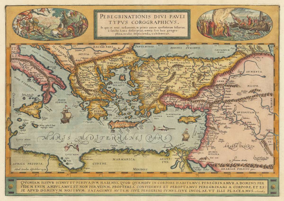
Peregrinationis Divi Pauli Typus Corographicus. In quo et noui testamenti, in primis autem apostolorum historiae, a...
€560.00
Prices incl. VAT plus shipping costs
This item is sold. Please contact us if you are searching for this item.
Eigenschaften
- Published: Antwerp
- Published date: 1612
- Technique: Copper engraving / later hand color
- Issue date: 1612
- Type: map
- Category: Mediterranean
- Size: 352 by 502mm (13¾ by 19¾ inches).
- Bibliography: Broe. 181 (1st state of 2)
- Stock number: 30710
- Condition: In excellent condition.
Article description
Article description
Original copper engraving, published 1612 in the famous historical atlas "Parergon" (Latin text-edition) by Abraham Ortelius. Finely later hand colored in wash and outline. A highly decorative map showing the travels of St. Paul in the Mediterrean. Decorated with two oval historical engraved scenes from the travels of St. Paul. The map is equipped with two sailing ships, a speer fish and a sea monster in the Mediterranean Sea. Engraved place names and towns are shown as miniature views, rivers and mountains are engraved, too. The bottom of the map contains a large text chapter in three lines: the fifth chapter of the Second Epistle to the Corinthians in the New Testament of the Christian Bible. It is authored by Paul the Apostle and Saint Timothy (2 Corinthians 5). The map was published for the first time in 1579 in the edition of the ,Theatrum Orbis Terrarum' and was published until 1624 in the atlas ,Parergon' by A. Ortelius. This is the first state of two, published 1612 with Latin text verso. The 1st state can be identified that the word ,Corographicus' has yet not been corrected to ,Chorographicus' and that the stippling around the sea names has not been added.Broe. 181 (1st state of 2)
You might also be interested in the following products
 Creta Iouis...
 Original antique copper engraving, decorative hand colored. Published 1612 in the historical Atlas...
€495.00
 M. Heberers...
 Original copper-engraving, uncoloured as published. This antique map shows?? Inside the map are many mountains,...
€240.00
 De zee en...
 Original copper-engraving, uncoloured as published. The famous Dutch publisher and mapmaker Pieter Van der Aa...
€175.00
 Ierusalem aus den...
 Original antique copper engraving, hand colored in outline and wash when published. This map was published in the...
€250.00
Recently viewed products