Petermann, A.
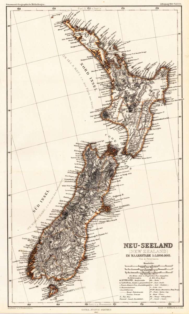
Neu-Seeland (New Zealand) im Masstabe 1:5.000.000. - Von A. Petermann
Petermann, A. – New Zealand · Lithograph, Printed in Colours · Petermanns Geographische Mitteilungen, Gotha · 1862
Eigenschaften
- Published: Justus Perthes. , Gotha
- Published date: 1862
- Type: Antique Map, map
- Technique: Lithograph / Original color.
- Issue date: 1862
- Category: New Zealand
- Size: 326 by 191mm (12¾ by 7½ inches).
- Stock number: 26541
- Condition: In excellent condition. The map was originally published folded, so that the old folds are still slightly visible. 326 by 191mm (12¾ by 7½ inches).
Article description
Article description
Original antique lithograph, printed in colours, published by Justus Perthes in Gotha for 'Petermanns Geographische Mitteilungen', 1862. Lithograph, original color as published. Sheet: 326 by 191mm (12¾ by 7½ inches).. August Heinrich Petermann (1822–1878) was one of the most important German cartographers and geographers of the 19th century. Born in Bleicherode, Saxony, he trained at the Geographische Kunstschule in Potsdam under Heinrich Berghaus — himself a leading student of Alexander von Humboldt. After a formative decade in Edinburgh and London (1845–1854), where he gained broad experience in the commercial and scientific aspects of cartography, Petermann returned to Gotha and joined the Justus Perthes publishing house. In 1855 he founded 'Petermanns Geographische Mitteilungen' (PGM), which swiftly became one of the world's foremost geographical journals — the definitive record of the great age of exploration and discovery. Petermann personally produced over 500 maps and signed 226 articles in PGM, ranging across Africa, the Polar regions, Asia, and the history and practice of cartography. In 1902, the eminent British cartographer J. G. Bartholomew wrote: 'No one has done more than he to advance modern cartography.' His maps are held in major institutions worldwide, including the Library of Congress, the British Library, and the Bibliothèque nationale de France. Detailled and exact map of New Zealand with the Northern and Southern Island. The map provides a lot of information on place names, cities, rivers, lakes, missions, bays, mountains, etc. Next to the title a mileage scale and an extensive table of explanation. In excellent condition. The map was originally published folded, so that the old folds are still slightly visible.Petermann, A. – New Zealand · Lithograph, Printed in Colours · Petermanns Geographische Mitteilungen, Gotha · 1862
You might also be interested in the following products
") Neu-Seeland (New...
Neu-Seeland (New... Original antique lithograph, hand coloured, published by Justus Perthes in Gotha for 'Petermanns Geographische...
€223.00
 Neuseeland mit...
 Original antique lithograph, hand coloured, published by Justus Perthes in Gotha for 'Petermanns Geographische...
€220.00
Recently viewed products