Petermann, A.
Karte von Kaukasien zur Übersicht der Physikalisch-Geographischen Grundzüge und der Wichtigsten Minerale. Von A....
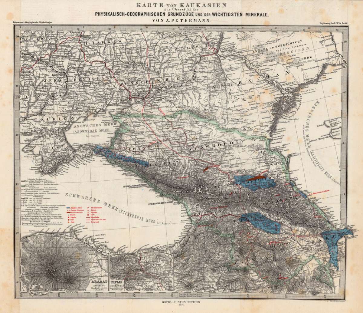
Petermann, A. – Caucasus Region · Lithograph, Printed in Colours · Petermanns Geographische Mitteilungen, Gotha · 1874
Eigenschaften
- Published: Justus Perthes. , Gotha
- Published date: 1874
- Type: Antique Map, map
- Technique: Lithograph / Original color.
- Issue date: 1874
- Category: Kaukasia
- Size: 340 by 415mm (13 by 16 inches).
- Stock number: 23526
- Condition: In very good to excellent condition. Minor marginal foxing, hardly affecting the image of the map. The map was originally published folded, so that the old folds are still slightly visible. 340 by 415mm (13 by 16 inches).
Article description
Article description
Original antique lithograph, printed in colours, published by Justus Perthes in Gotha for 'Petermanns Geographische Mitteilungen', 1874. Lithograph, original color in outline and wash. Sheet: 340 by 415mm (13 by 16 inches).. August Heinrich Petermann (1822–1878) was one of the most important German cartographers and geographers of the 19th century. Born in Bleicherode, Saxony, he trained at the Geographische Kunstschule in Potsdam under Heinrich Berghaus — himself a leading student of Alexander von Humboldt. After a formative decade in Edinburgh and London (1845–1854), where he gained broad experience in the commercial and scientific aspects of cartography, Petermann returned to Gotha and joined the Justus Perthes publishing house. In 1855 he founded 'Petermanns Geographische Mitteilungen' (PGM), which swiftly became one of the world's foremost geographical journals — the definitive record of the great age of exploration and discovery. Petermann personally produced over 500 maps and signed 226 articles in PGM, ranging across Africa, the Polar regions, Asia, and the history and practice of cartography. In 1902, the eminent British cartographer J. G. Bartholomew wrote: 'No one has done more than he to advance modern cartography.' His maps are held in major institutions worldwide, including the Library of Congress, the British Library, and the Bibliothèque nationale de France. Interesting map of Kaukasia with two inset maps of Mt. Ararat and the surrounding of Tiflis. In very good to excellent condition. Minor marginal foxing, hardly affecting the image of the map. The map was originally published folded, so that the old folds are still slightly visible.Petermann, A. – Caucasus Region · Lithograph, Printed in Colours · Petermanns Geographische Mitteilungen, Gotha · 1874
You might also be interested in the following products
 Tabula Asiae II...
 Fine copper-engraved map, printed into the full text page, published in Geografia ... Universale de la Terra , which...
€145.00
 Tartariae Imperium
 Fine copper-engraved map, printed into the full text page, published in 'Geografia ... Universale de la...
€509.00
 Von den Ländern...
 Woodcut published 1628 in the Cosmographia by Sebastian Münster. Early woodcut map published in the 1628 edition...
€95.00
 Dwina Fluuius.
 Original antique copper engraving, hand colored in outline and wash when published. The map is divided into three...
€300.00
Recently viewed products