Homann, J.B. (Homann Heirs)
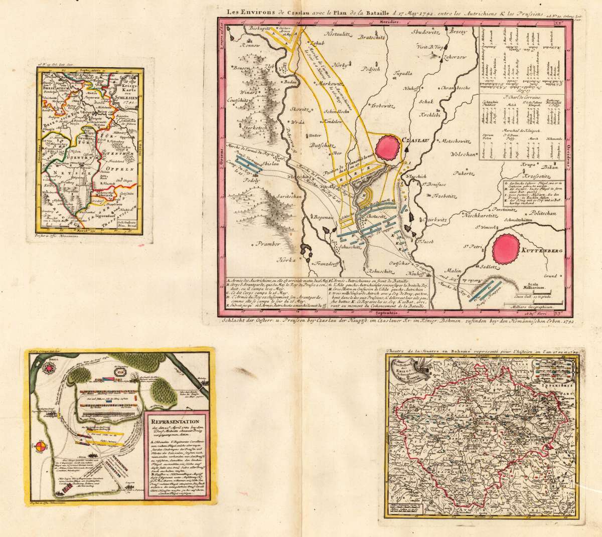
Les Environs de Czaslau avec le Plan de la Bataille d. 17. May 1742 entre les Autrichiens & les Prussiens -...
€300.00
Prices incl. VAT plus shipping costs
This item is sold. Please contact us if you are searching for this item.
Eigenschaften
- Published: Homann , Nürnberg
- Published date: 1742
- Type: Antique Map, map
- Technique: Copper engraving / handcolored.
- Issue date: 1742
- Size: 490 by 532mm (19 by 21 inches).
- Stock number: 26655
- Condition: In excellent condition. 490 by 532mm (19 by 21 inches).
Article description
Article description
Original antique copper engraving, hand colored in outline and wash when published. Vier Karten wurden hier auf einem Blatt gedruckt. Links oben wurde die Kriegskarte von Schlesien von 1741 angebracht. Rechts daneben die Karte der Schlacht von Czaslau (auch als Schlacht von Chotisitz oder Chotusice bekannt), die am 17. Mai 1742 zwischen den Österreichern unter dem Kommando von Prinz Charles Alexander von Lothringen und den Preußen unter dem Kommando von Friedrich II. Von Preußen ausgetragen wurde , was zu einem preußischen Sieg führte. Erster Schlesischer Krieg: Teil des Österreichischen Erbfolgekrieges. Orientiert mit Süden nach oben. Die Schlacht von Czaslau wurde von den Preußen gewonnen, deren Marschrouten und Lager blau dargestellt sind; die der Österreicher sind gelb gefärbt. Die Schlacht wurde am Boden zwischen Czaslau und Chotusitz ausgetragen. Kuttenberg liegt im Nordwesten. Unten links den Plan der Schlacht bei Mollwitz, einem Dorf in Schlesien, 20 km südöstlich von Breslau. Die Preußen errangen am 10. April 1741 den ersten Sieg über die österreichischen Habsburger im Ersten Schlesischen Krieg. Unten rechts ist die Karte von der ,Vorstellung des Kriegsschauplatzes in Böhmen' von Homann gedruckt. Rechts oben eine Zeichenerklärung und der Meilenzeiger ist unten links eingraviert. Johann Baptist Homann (20 March 1664 – 1 July 1724) was a German geographer and cartographer, who also made maps of the Americas. Homann was born in Oberkammlach near Kammlach in the Electorate of Bavaria. Although educated at a Jesuit school, and preparing for an ecclesiastical career, he eventually converted to Protestantism and from 1687 worked as a civil law notary in Nuremberg. He soon turned to engraving and cartography; in 1702 he founded his own publishing house. Homann acquired renown as a leading German cartographer, and in 1715 was appointed Imperial Geographer by Emperor Charles VI. Giving such privileges to individuals was an added right that the Holy Roman Emperor enjoyed. In the same year he was also named a member of the Prussian Academy of Sciences in Berlin. Of particular significance to cartography were the imperial printing privileges (Latin: privilegia impressoria). These protected for a time the authors in all scientific fields such as printers, copper engravers, map makers and publishers. They were also very important as a recommendation for potential customers. In 1716 Homann published his masterpiece Grosser Atlas ueber die ganze Welt (Grand Atlas of all the World). Numerous maps were drawn up in cooperation with the engraver Christoph Weigel the Elder, who also published Siebmachers Wappenbuch. Homann died in Nuremberg in 1724. He was succeeded by his son Johann Christoph (1703-1730). The company carried on upon his death as Homann heirs company, managed by Johann Michael Franz and Johann Georg Ebersberger. After subsequent changes in management the company folded in 1852.[1] The company was known as "Homann Erben", "Homanniani Heredes", or "Heritiers de Homann" abroad. (Wikipedia)You might also be interested in the following products
 Marchionatus...
 Original antique copper engraving, hand colored and wash when published. Northern sheet of the district map of...
€150.00
 Marchionatus...
 Original antique copper engraving, hand colored and wash when published. This decorative map shows Moravia in...
€195.00
 Commotau
 Copper engraving, uncolored as published. City view of the city of Commotau in Bohemia, published in the Topographia...
€155.00
 Schlan
 Copper engraving, uncolored as published. City view of the city of Schlan in Bohemia, published in the Topographia...
€125.00
Recently viewed products