Homann, Johann Baptist
Ducatus Wurtenbergici cum Locis limitaneinis, iapote maxima parte Circuli Suevici praesertim Utroq. Marchionatu...


€550.00
Prices incl. VAT plus shipping costs
This item is sold. Please contact us if you are searching for this item.
Eigenschaften
- Published: Homann , Nürnberg
- Published date: 1730
- Technique: Copper engraving / Original color.
- Type: Antique Map, map
- Category: Baden-Württemberg
- Issue date: 1730-35
- Size: 58 x 96 cm (22.75 x 37,75 inches).
- Stock number: 16864
- Condition: In excellent condition.
Article description
Article description
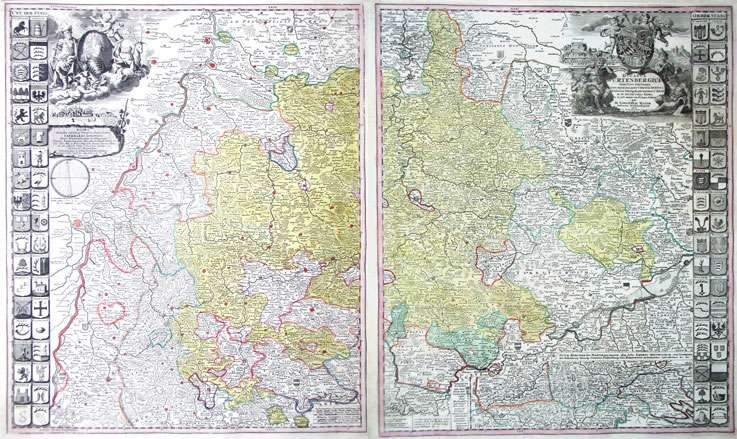
Original antique copper engravings, hand colored in outline and wash, when published. Published by J.B. Homann after the sketch of Ioh. Maier. Two maps to join together to form a large map. A fine copy, published plano without centerfolds in one of J.B. Homann's atlases around 1730-35. This large and fine map, showing the duchy of Wurtemberg., is one of the most decorative maps of Wurtemberg, produced in the 18th century. The map consists of two sheets, either to join together or to frame next to each other. It is a very large scale map of the duchy of Wurtemberg and is ornated on both sides with 76 coat of arms. Two large title-cartouches are on the map, both of them with allegories. On the bottom of the map we find an inset map of the black forest. Johann Baptist Homann (20 March 1664 – 1 July 1724) was a German geographer and cartographer, who also made maps of the Americas. Homann was born in Oberkammlach near Kammlach in the Electorate of Bavaria. Although educated at a Jesuit school, and preparing for an ecclesiastical career, he eventually converted to Protestantism and from 1687 worked as a civil law notary in Nuremberg. He soon turned to engraving and cartography; in 1702 he founded his own publishing house. Homann acquired renown as a leading German cartographer, and in 1715 was appointed Imperial Geographer by Emperor Charles VI. Giving such privileges to individuals was an added right that the Holy Roman Emperor enjoyed. In the same year he was also named a member of the Prussian Academy of Sciences in Berlin. Of particular significance to cartography were the imperial printing privileges (Latin: privilegia impressoria). These protected for a time the authors in all scientific fields such as printers, copper engravers, map makers and publishers. They were also very important as a recommendation for potential customers. In 1716 Homann published his masterpiece Grosser Atlas ueber die ganze Welt (Grand Atlas of all the World). Numerous maps were drawn up in cooperation with the engraver Christoph Weigel the Elder, who also published Siebmachers Wappenbuch. Homann died in Nuremberg in 1724. He was succeeded by his son Johann Christoph (1703-1730). The company carried on upon his death as Homann heirs company, managed by Johann Michael Franz and Johann Georg Ebersberger. After subsequent changes in management the company folded in 1852.[1] The company was known as "Homann Erben", "Homanniani Heredes", or "Heritiers de Homann" abroad. (Wikipedia)You might also be interested in the following products
 Württemberg...
 Hand-Colored Original Copperplate Engraving by Petrus Schenk & Gerard Valck, depicting Württemberg Herzogtum....
€450.00
 Circuli Sueviae...
 Hand-Colored Original Copperplate Engraving by Johann Baptist Homann, depicting Circuli Sueviae Mappa ex subsidiis...
€345.00
 Pharus-Plan...
 Original Lithograph by Pharus Verlag, depicting Pharus-Plan Stuttgart. Published Pharus Verlag, Berlin, 1910. Sheet:...
€95.00
 Circulus Suevicus...
 Hand-Colored Original Copperplate Engraving by Matthäus Seutter, depicting Circulus Suevicus in quo Ducatus...
€450.00
Recently viewed products