Ortelius, Abraham
Franken
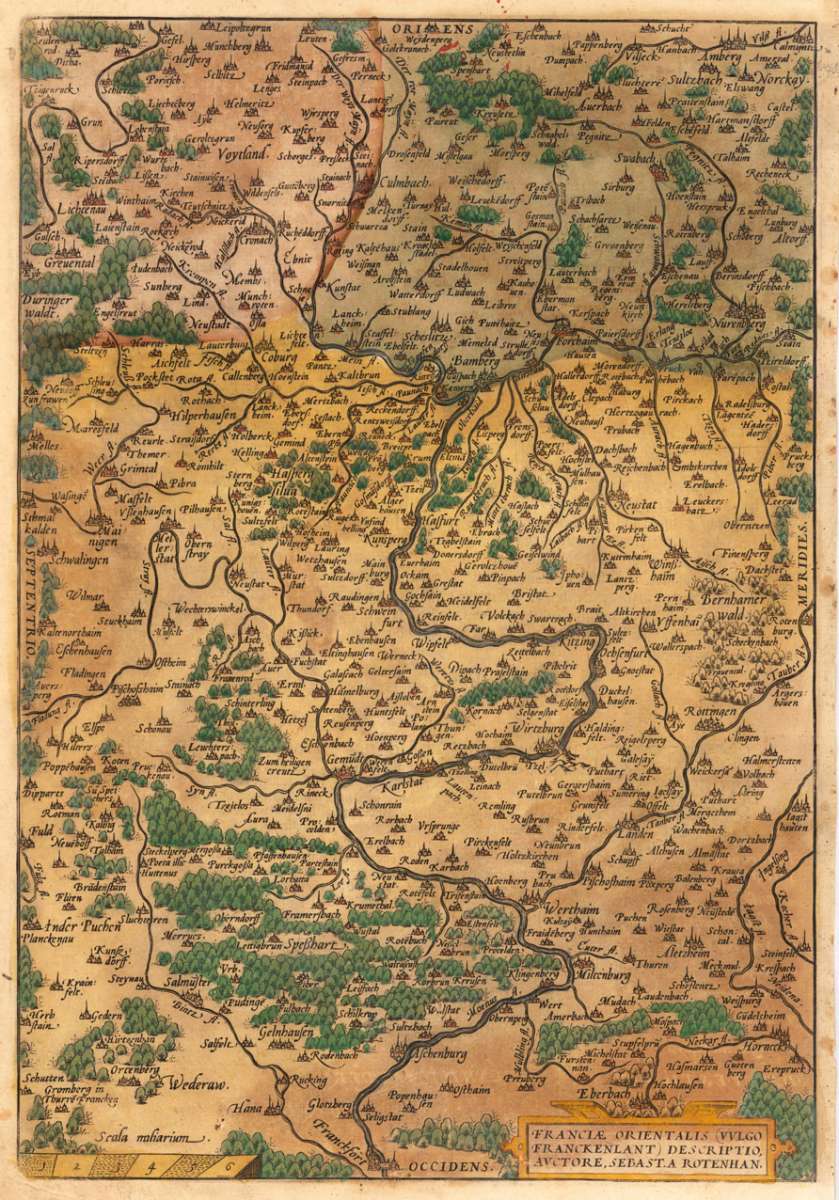
Franciae Orientalis (Vulgo Franckenlant) Descriptio, Auctore, Sebast. A. Rotenhan.
€295.00
Prices incl. VAT plus shipping costs
This item is sold. Please contact us if you are searching for this item.
Eigenschaften
- Published: Platin , Antwerpen
- Published date: 1580
- Type: Antique Map, map
- Issue date: 1580
- Category: Franken
- Technique: Kupferstich, original Kolorit.
- Size: 364 by 252mm (14 by 10 inches).
- Bibliography: Broe. 100a
- Stock number: 29132
- Condition: Tadellos u. schön, in dekorativem Kolorit. 364 by 252mm (14 by 10 inches).
Article description
Article description
Original antique copper engraving, hand colored. Engraving map in decorative coloring, published in the Theatrum Orbis Terrarum by A. Ortelius, Latin. Issue at Diesth. Franken is shown after the drawing by Sebastian Rotenhan. North is on the left side of the map. From Frankfurt am Main in the west to the source of the Main in the east. Colored Title cartouche at the bottom right and the mileage scale is engraved on the left side. Ortelius was born on 14 April 1527 in the city of Antwerp, which was then in the Habsburg Netherlands (modern-day Belgium). The Orthellius family were originally from Augsburg, a Free imperial city of the Holy Roman Empire. In 1535, the family had fallen under suspicion of Protestantism. Following the death of Ortelius's father, his uncle Jacobus van Meteren returned from religious exile in England to take care of Ortelius. Abraham remained close to his cousin Emanuel van Meteren, who would later move to London. In 1575 he was appointed geographer to the king of Spain, Philip II, on the recommendation of Arias Montanus, who vouched for his orthodoxy. He travelled extensively in Europe and is specifically known to have traveled throughout the Seventeen Provinces; in southern, western, northern, and eastern Germany (e.g., 1560, 1575–1576); France (1559–1560); England and Ireland (1576); and Italy (1578, and perhaps twice or thrice between 1550 and 1558). Beginning as a map-engraver, in 1547 he entered the Antwerp Guild of Saint Luke as an illuminator of maps. He supplemented his income trading in books, prints, and maps, and his journeys included yearly visits to the Frankfurt book and print fair, where he met Gerardus Mercator in 1554. In 1560, however, when travelling with Mercator to Trier, Lorraine, and Poitiers, he seems to have been attracted, largely by Mercator's influence, towards the career of a scientific geographer. (Wikipedia)Franciae Orientalis (Vulgo Franckenlant) Descriptio, Auctore, Sebast. A. Rotenhan.
Broe. 100a
You might also be interested in the following products
 Mindelheim.
 Original antique copper engraving, hand colored in outline and wash when published. Decorative district map of...
€475.00
 Augspurg mit...
 Original antique copper engraving, hand colored in outline and wash when published. This antique map shows us the...
€195.00
 Circulus...
 Original antique copper engraving, hand colored in outline and wash when published. The map shows the area between...
€195.00
 Oberbayern
 Original antique copper engraving in full contemporary handcolor in wash and outline when published. A highly...
€295.00
Recently viewed products