Weigel, Christoph
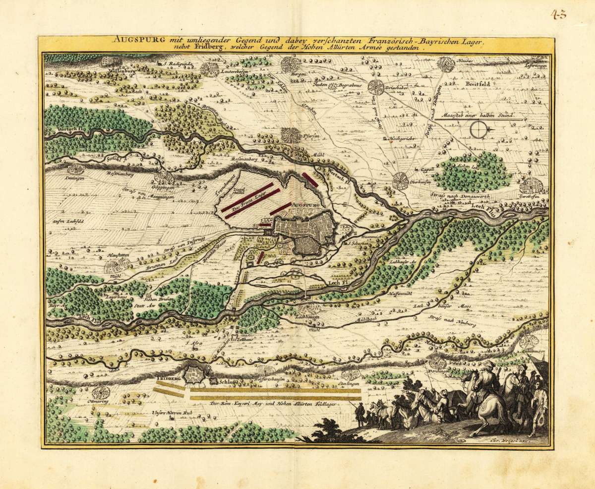
Augspurg mit umliegender Gegend und dabey verschanzten Französisch-Bayrischen Lager, nebst Fridberg, welcher Gegend...
Augspurg mit umliegender Gegend und dabey verschanzten Französisch-Bayrischen Lager, nebst Fridberg, welcher Gegend der Hohen Allürten Armee gestanden. - Chr...
Eigenschaften
- Published: Chr. Weigel. , Nürnberg
- Published date: 1719
- Technique: Copper engraving / Original color.
- Type: Antique Map, map
- Issue date: 1719-35
- Category: Augsburg
- Size: 280 by 349mm (11 by 13 inches).
- Stock number: 19496
- Condition: In excellent condition. 280 by 349mm (11 by 13 inches).
Article description
Article description
Hand-Colored Original Copperplate Engraving by Christoph Weigel, depicting Augspurg mit umliegender Gegend und dabey verschanzten Französisch-Bayrischen Lager, nebst Fridberg, welcher Gegend der Hohen Allürten Armee gestanden.. Published Nürnberg, Chr. Weigel., 1719. Sheet: 280 by 349mm (11 by 13 inches).. A fine and original hand-colored example of Weigel's celebrated cartographic work, documenting this region of Germany with the precision and decorative artistry characteristic of the 17100s. Christoph Weigel (1654-1725) was a German engraver, art dealer, and publisher based in Nuremberg. He was one of the most active publishers of illustrated books and maps in early 18th-century Germany, producing maps, city views, and topographic prints of high quality. His maps of German territories are distinguished by their careful engraving and are valued by collectors for their historical accuracy and decorative appeal. This original copperplate engraving, with original hand coloring depicts the region of Augspurg mit umliegender Gegend und dabey verschanzten Französisch-Bayrischen Lager, nebst Fridberg, welcher Gegend der Hohen Allürten Armee gestanden., published in Nürnberg, Chr. Weigel., 1719-35. The map features a decorative Baroque cartouche containing the title inscription. The cartouche is elaborated with allegorical or figural ornamentation. The map records the political and geographic boundaries of the region as understood in 1719-35, offering a fascinating window into the history of German territorial organization. Sheet measures 280 by 349mm (11 by 13 inches).. In good condition overall, with minor signs of age appropriate for a 18th-century engraving. Ready to frame.Augspurg mit umliegender Gegend und dabey verschanzten Französisch-Bayrischen Lager, nebst Fridberg, welcher Gegend der Hohen Allürten Armee gestanden. - Chr...
You might also be interested in the following products
 Mindelheim.
 Hand-Colored Original Copperplate Engraving by Johann Baptist Homann, depicting Mindelheim.. Published Nürnberg,...
€475.00
 Circulus...
 Hand-Colored Original Copperplate Engraving by Christoph Weigel, depicting Circulus Franconicus ad Occidentem vergens...
€195.00
 Oberbayern
 Hand-Colored Original Copperplate Engraving by Johann Baptist Homann, depicting Oberbayern. Published Nürnberg,...
€295.00
 Die Ludwigsbrücke...
 Hand-Colored Original Steel Engraving by Ludwig Lange, depicting Die Ludwigsbrücke in Bamberg.. Published München, G....
€40.00
Recently viewed products