Homann, Johann Baptist
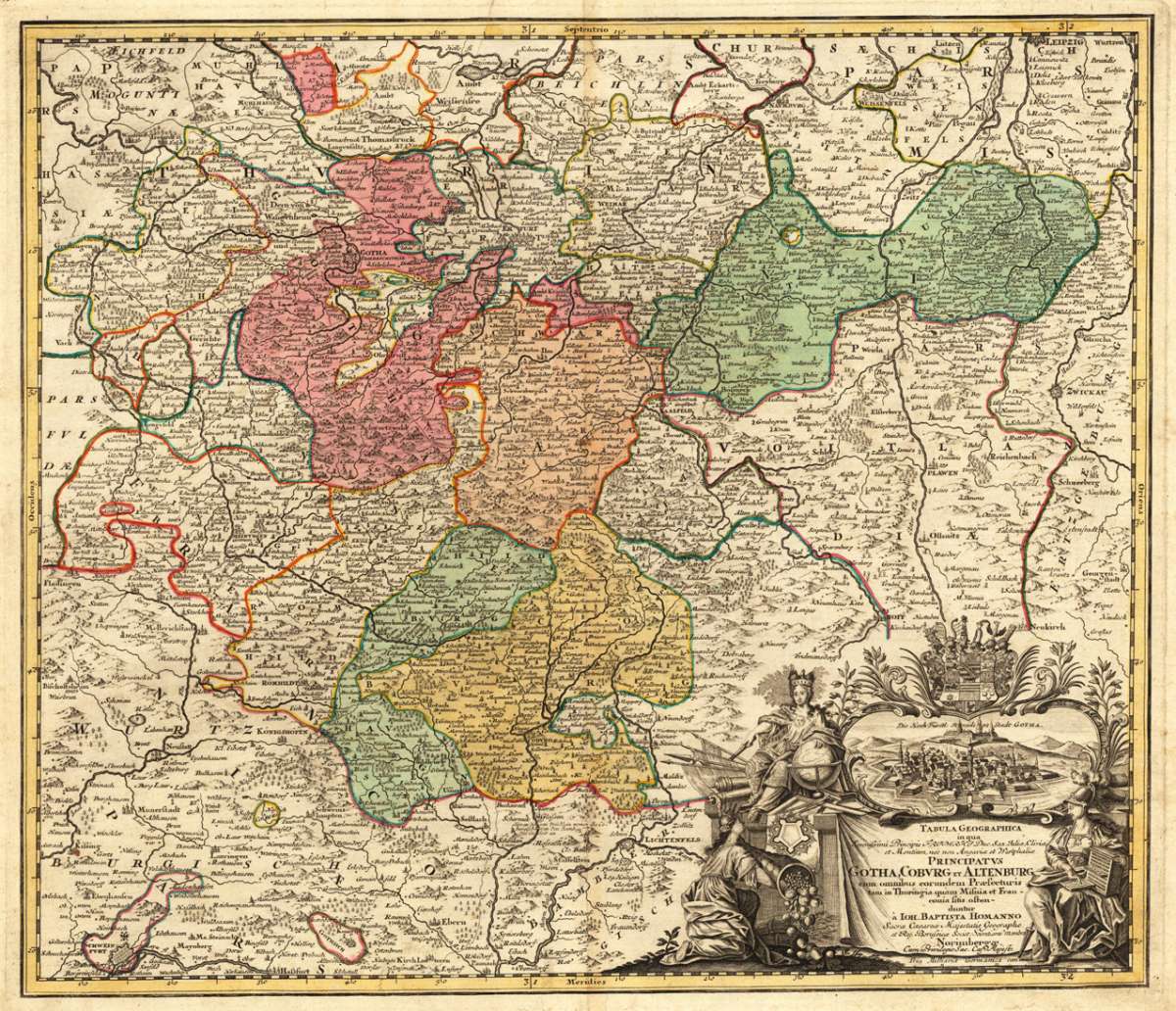
Tabula Geographica in qua Serenissimi Principis Friderici Duc. Sax. Juliae, Cliviae, et Montium, nee non angariae et...
€295.00
Prices incl. VAT plus shipping costs
This item is sold. Please contact us if you are searching for this item.
Eigenschaften
- Published: Johann Baptist Homann , Nürnberg
- Published date: 1720
- Technique: Copper engraving / Original color.
- Type: Antique Map, map
- Issue date: 1720-30
- Category: Gotha, Coburg und Altenburg
- Size: 481 by 563mm (19 by 22 inches).
- Stock number: 29780
- Condition: In excellent condition. 481 by 563mm (19 by 22 inches).
Article description
Article description
Original antique copper engraving, hand colored in outline and wash, when published. Dekorative Karte des Fürstentums Gotha, Coburg und Altenburg mit seinen Regionen nach Thüringen und Franken. Die Karte erstreckt sich von Norden von Leipzig, Naumburg über Ruldolstadt und Saalfeld nach Coburg und Lichtenfels. Shweinfurt am Main liegt im südöstlichen Teil der Karte. Mit vielen Ortsnamen, politischen Grenzen, gravierten Bergen, Flüssen, Seen, Wäldern usw. Die reichhaltige allegorische Titelkartusche in der unteren rechten Ecke mit einer schönen Stadtansicht auf die Residenzstadt Gotha. Decorative map of the principality of Gotha, Coburg and Altenburg with its regions towards Thuringia and Franconia. The map extends from the north from Leipzig, Naumburg across Ruldolstadt and Saalfeld towards Coburg and Lichtenfels. Shweinfurt at the river Main is in the southeastern portion of the map. With many place names, political borders, engraved mountains, rivers, lakes, woods, etc. The rich allegoric title cartouche in the lower right corner with a beautiful city view of the residence town Gotha. Johann Baptist Homann (20 March 1664 – 1 July 1724) was a German geographer and cartographer, who also made maps of the Americas. Homann was born in Oberkammlach near Kammlach in the Electorate of Bavaria. Although educated at a Jesuit school, and preparing for an ecclesiastical career, he eventually converted to Protestantism and from 1687 worked as a civil law notary in Nuremberg. He soon turned to engraving and cartography; in 1702 he founded his own publishing house. Homann acquired renown as a leading German cartographer, and in 1715 was appointed Imperial Geographer by Emperor Charles VI. Giving such privileges to individuals was an added right that the Holy Roman Emperor enjoyed. In the same year he was also named a member of the Prussian Academy of Sciences in Berlin. Of particular significance to cartography were the imperial printing privileges (Latin: privilegia impressoria). These protected for a time the authors in all scientific fields such as printers, copper engravers, map makers and publishers. They were also very important as a recommendation for potential customers. In 1716 Homann published his masterpiece Grosser Atlas ueber die ganze Welt (Grand Atlas of all the World). Numerous maps were drawn up in cooperation with the engraver Christoph Weigel the Elder, who also published Siebmachers Wappenbuch. Homann died in Nuremberg in 1724. He was succeeded by his son Johann Christoph (1703-1730). The company carried on upon his death as Homann heirs company, managed by Johann Michael Franz and Johann Georg Ebersberger. After subsequent changes in management the company folded in 1852.[1] The company was known as "Homann Erben", "Homanniani Heredes", or "Heritiers de Homann" abroad. (Wikipedia)You might also be interested in the following products
 Mindelheim.
 Original antique copper engraving, hand colored in outline and wash when published. Decorative district map of...
€475.00
 Augspurg mit...
 Original antique copper engraving, hand colored in outline and wash when published. This antique map shows us the...
€195.00
 Circulus...
 Original antique copper engraving, hand colored in outline and wash when published. The map shows the area between...
€195.00
 Oberbayern
 Original antique copper engraving in full contemporary handcolor in wash and outline when published. A highly...
€295.00
Recently viewed products