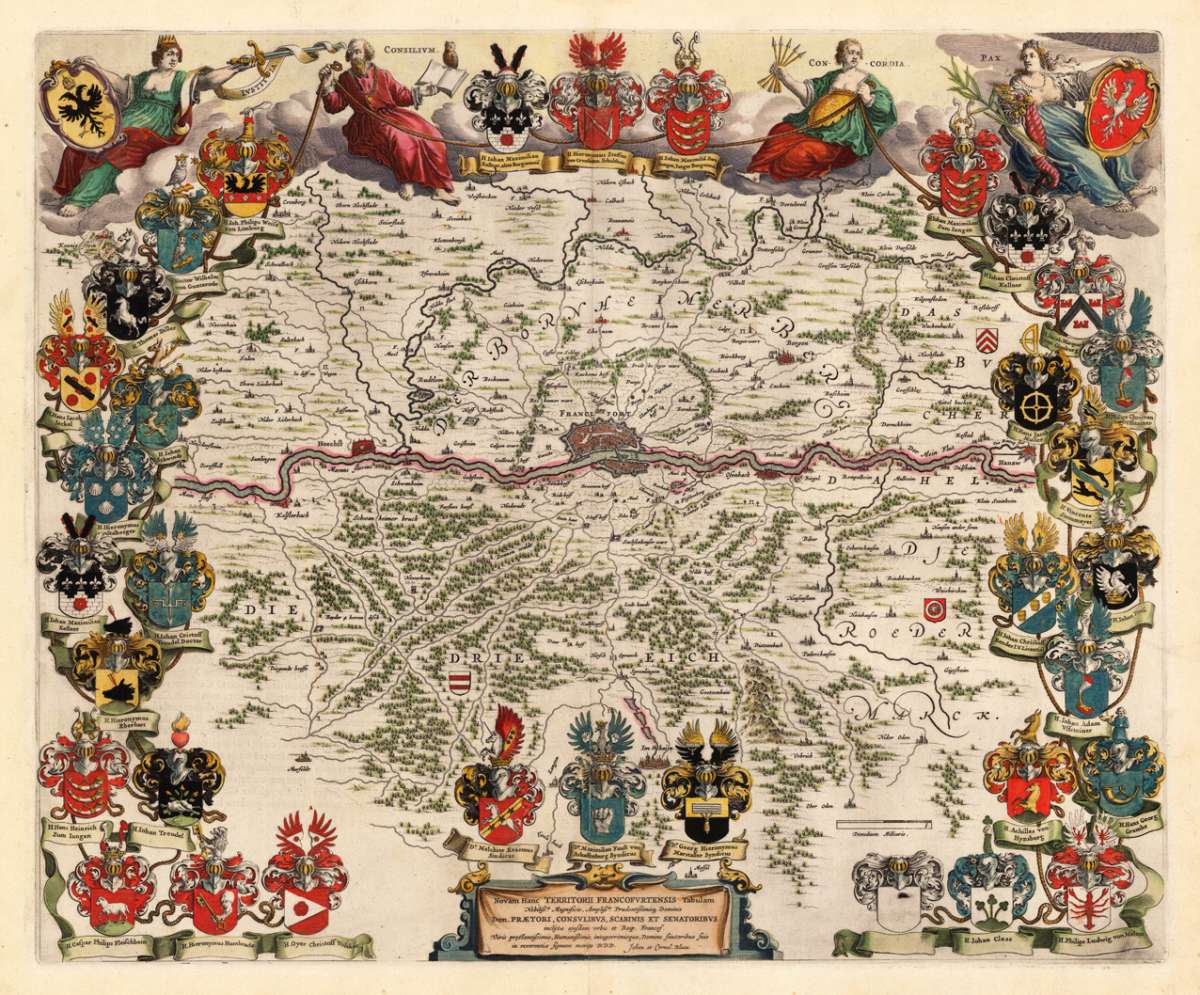
Blaeu, Guijelmus & Joan.
Novam Hanc Territorii Francofurtensis Tabulam Nobilißis Magnificis, Amplißis Prudentißimisq Dominis Dnn. Praetori,...
Prices incl. VAT plus shipping costs
This item is sold. Please contact us if you are searching for this item.
- Published: Blaeu , Amsterdam
- Published date: 1649
- Type: Antique Map, map
- Issue date: 1649
- Category: Frankfurt
- Technique: Copper engraving / Original color
- Size: 450 by 553mm (17 by 21 inches).
- Stock number: 28276
- Condition: In excellent condition. 450 by 553mm (17 by 21 inches).
Article description
Original antique copper engraving, hand colored in outline and wash when published. Beautiful hand colored engraved map with Frankfurt in the centre, the river Main running horizontally across with Hanaw on its banks in the east, and Kelsterbach in the west. Many other smaller towns represented by small churches etc. The map ornamented on with the crests and arms of local nobility, 4 decorative figures of Pax, Concordia, Consilium and Justitia at upper margin. Joan Blaeu (23 September 1596 – 21 December 1673) was a Dutch cartographer born in Alkmaar, the son of cartographer Willem Blaeu. In 1620 he became a doctor of law but he joined the work of his father. In 1635 they published the Atlas Novus (full title: Theatrum orbis terrarum, sive, Atlas novus) in two volumes. Joan and his brother Cornelius took over the studio after their father died in 1638. Joan became the official cartographer of the Dutch East India Company. Blaeu's world map, Nova et Accuratissima Terrarum Orbis Tabula, incorporating the discoveries of Abel Tasman, was published in 1648. This map was revolutionary in that it "depicts the solar system according to the heliocentric theories of Nicolaus Copernicus, which show the earth revolving around the sun.... Although Copernicus's groundbreaking book On the Revolutions of the Spheres had been first printed in 1543, just over a century earlier, Blaeu was the first mapmaker to incorporate this revolutionary heliocentric theory into a map of the world." Blaeu's map was copied for the map of the world set into the pavement of the Groote Burger-Zaal of the new Amsterdam Town Hall, designed by the Dutch architect Jacob van Campen (now the Amsterdam Royal Palace), in 1655. Blaeu's Hollandia Nova was also depicted in his Archipelagus Orientalis sive Asiaticus published in 1659 in the Kurfürsten Atlas (Atlas of the Great Elector). and used by Melchisédech Thévenot to produce his map, Hollandia Nova—Terre Australe (1664). As Joan Blaeu, he also published the 12 volume "Le Grand Atlas, ou Cosmographie blaviane, en laquelle est exactement descritte la terre, la mer, et le ciel". One edition is dated 1663. That was folio (540 x 340 mm), and contained 593 engraved maps and plates. In March 2015, a copy was on sale for £750,000. Around 1649 Joan Blaeu published a collection of Dutch city maps named Toonneel der Steeden (Views of Cities). In 1651 he was voted into the Amsterdam council. In 1654 Joan published the first atlas of Scotland, devised by Timothy Pont. In 1662 he reissued the Atlas Novus, also known as Atlas Maior, in 11 volumes, and one for oceans.[citation needed] A cosmology was planned as their next project, but a fire destroyed the studio completely in 1672. (Wikipedia)
You might also be interested in the following products
 Hassia Landgraviatus
  Nassovia Comitatus.
  Waldeck Comitatus.
  Li Circoli dell...