Plancius, Petrus
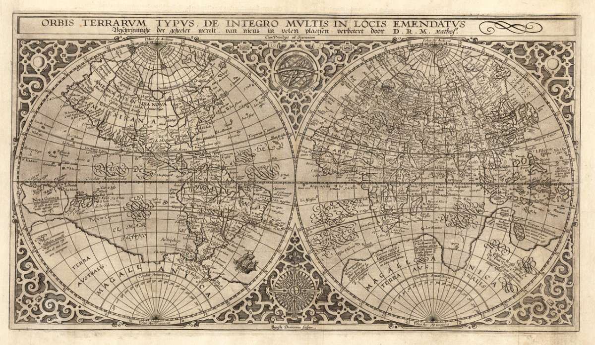
Orbis Terrarum Typus. De Integro Multis in Locis Ememdatus.
€4,400.00
Prices incl. VAT plus shipping costs
This item is sold. Please contact us if you are searching for this item.
Eigenschaften
- Published: Amsterdam
- Published date: 1590
- Type: Antique Map, map
- Technique: Copper engraving / Uncolored
- Issue date: 1590
- Category: world map by Plancius
- Size: 282 by 505mm (11 by 20 inches).
- Bibliography: Shirley 177 (state 3); Schilder map 17
- Stock number: 27968
- Condition: A very good impression, left and right margins trimmed to the engraved border line and re-margined. These repairs are skillfully done and are only visible on very close inspection. In very good condition.
Article description
Article description
Copper engraving, uncolored as published. Engraved by Baptista Doetecum. Verso with Dutch text. Rare world map, first published in 1590. The map is based on Rumold Mercartor´s world map of 1587. It includes improvements, which were made by Abraham Ortelius, a re-shaped South America and includes the Salomon Islands in the Pacific Ocean. Plancius included new information of the Portuguese explorations on the west coast of America and the western African coast line. Japan is shown for the first time (not entirely correctly) as one small and three larger islands. This is state 3, in which Plancius's name in the title has been erased and replaced by ,D.R.M. Mathes'. It is unknown, who is represented by the initials ,D.R.M.' or whether ,Mathes' is a surname or may be an abbreviation for ,mathematician' (Shirley).Shirley 177 (state 3); Schilder map 17
You might also be interested in the following products
 Die Erde in zwey...
 Original antique copper engraving, hand colored in outline and wash, when published. A decorative world map by...
€350.00
 Mappe-Monde...
 Copper engraving, handcolored in outline, when published. Fine and decorative world map in two hemispheres by Robert...
€2,150.00
 Hemisphere...
 Copper-engraving, uncoloured as published. Fine example of a strong impression of this large map showing the...
€1,050.00
 Mappe-Monde ou...
 Copper-engraving, hand colored in outline when published. Decorative early 19th century world map showing the world...
€260.00
Recently viewed products