The following products have been found matching your search "interesting": 149
No results were found for the filter!
 Les Isles de la Guadeloupe, de Marie Galante, de la Dèsirade, et Celles des Saintes: Colonie Francoise dans les...
 Copper engraving, uncolored as published. A decorative antique map of the island Guadeloupe with the neighboring...
€95.00
![[South America] Antique [South America]](https://bergbook.com/media/image/10/a8/03/21905_500x500.jpg) [South America]
[South America] Copper engraving, uncolored as published. A fine detailed and interesting map engraved by Bellin after earlier...
€50.00
 Carte de L´Isle Celebes ou Macassar. Pour servir a l´Histoire Generale des Voyages.
 Copper engraving. Published in an atlas volume of Nicolaus Bellin's ,Histoire generale des Voyages' around 1760 in...
€65.00
 Carta dell`Isola Celebes ou Macassar. Pour servir a l´Histoire Generale des Voyages.
 Copper engraving. Published in an atlas volume of Nicolaus Bellin's ,Histoire generale des Voyages' around 1760 in...
€65.00
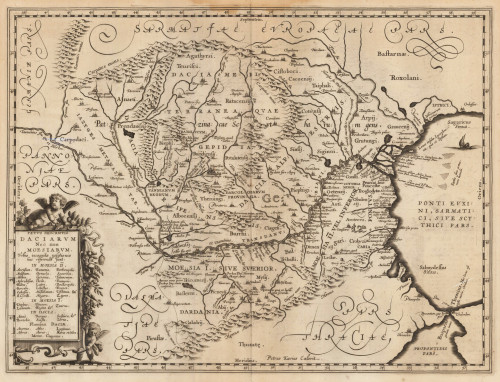
 Vetus Descriptio Daciarum Nec non Moesiarum Petrus Kaerius Caelavit.
 Original antique copper engraving. This interesting map shows Romania. Romania is a country at the crossroads of...
€395.00
 Electoratus Brandenburgi Mekelenburgi. Et maximae Partis Pomeraniae novissima Tabula.
 Original anitque copper engraving, hand colored in outline and wash when published. An interesting Visscher map of...
€495.00
 Der westliche Theil von Mittel-Asien oder Turan mit einem Theil der angaenzenden Laender. Entworfen und gezeichnet...
 Original antique copper engraving, hand colored in outline when published. A detailed and interesting map by the...
€145.00
 India extra Gangem, quae Europeis propinquior est.
 Original antique rare woodcut map, later hand colored, published in Johann Honter's "Rudimenta...
€145.00
 Sumatra Insula (Taprobana)
 Original antique rare woodcut map, later hand colored, published in Johann Honter's "Rudimenta Cosmographica" in...
€125.00
 Gades oder Cales Males durch die Englischen und Hollenaer
 Original antique copper engraving, uncolored. German text edition. Interesting battle plan of the Cadiz area and...
€225.00
 Karte von Gross Thibet zu der Allgemeinen Reisebeschreibung. Aus den Englischen Schriftstellern von M. Bellin...
 Copper engraving, uncolored as published. A fine detailed and interesting map engraved by Bellin after earlier...
€55.00
 Frauens Person aus der nordlichen Tartarey vom Grueber.
 Original antique copper engraving, uncolored as published. A fine detailed and interesting map engraved by Bellin...
€35.00

