Homann, J.B. (Homann Heirs)
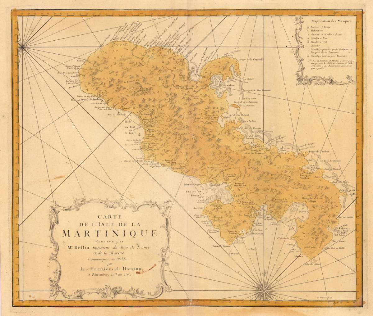
Carte De L' Isle De La Martinique dressée par Mr. Bellin, Ingenieur du Roy de France et de la Marine communiquée au...
Eigenschaften
- Published: Homann , Nürnberg
- Published date: 1762
- Technique: Copper engraving / Original color.
- Type: Antique Map, map
- Category: Martinique
- Issue date: 1762
- Size: 470 by 550mm (18 by 21 inches).
- Stock number: 15503
- Condition: A minor ink soiling in the lower cartouche and a marginal waterstaining in the lower margin, however not affecting the image. 470 by 550mm (18 by 21 inches).
Article description
Article description
Original antique copper engraving, hand colored in outline and wash when published. In the lower left corner ornated with a decorative title cartouche, in the upper right corner we find a cartouche with explanations to the map. Published 1762 by Homanns Heirs after the cartographic scources of Bellin. A very detailled map in a large scale showing many villages and settlements, rivers, mountains, ports and streets as well. Johann Baptist Homann (20 March 1664 – 1 July 1724) was a German geographer and cartographer, who also made maps of the Americas. Homann was born in Oberkammlach near Kammlach in the Electorate of Bavaria. Although educated at a Jesuit school, and preparing for an ecclesiastical career, he eventually converted to Protestantism and from 1687 worked as a civil law notary in Nuremberg. He soon turned to engraving and cartography; in 1702 he founded his own publishing house. Homann acquired renown as a leading German cartographer, and in 1715 was appointed Imperial Geographer by Emperor Charles VI. Giving such privileges to individuals was an added right that the Holy Roman Emperor enjoyed. In the same year he was also named a member of the Prussian Academy of Sciences in Berlin. Of particular significance to cartography were the imperial printing privileges (Latin: privilegia impressoria). These protected for a time the authors in all scientific fields such as printers, copper engravers, map makers and publishers. They were also very important as a recommendation for potential customers. In 1716 Homann published his masterpiece Grosser Atlas ueber die ganze Welt (Grand Atlas of all the World). Numerous maps were drawn up in cooperation with the engraver Christoph Weigel the Elder, who also published Siebmachers Wappenbuch. Homann died in Nuremberg in 1724. He was succeeded by his son Johann Christoph (1703-1730). The company carried on upon his death as Homann heirs company, managed by Johann Michael Franz and Johann Georg Ebersberger. After subsequent changes in management the company folded in 1852.[1] The company was known as "Homann Erben", "Homanniani Heredes", or "Heritiers de Homann" abroad. (Wikipedia)You might also be interested in the following products
 Moluccae Insulae...
 Original antique copper engraving, hand colored in outline and wash when published. A highly decorative map of the...
€550.00
 Pascaert van...
 Original antique copper engraving, uncolored as published. Detailed chart of the Northeastern part of Canada,...
€1,750.00
 Pascaarte vande...
 Original antique copper engraving, uncolored as published. A highly detailed and decorative sea chart of Greenland...
€1,100.00
 Guiana sive...
 Copper engraving, hand colored in outline and wash when published. French text edition. Decorative map extending...
€325.00
Recently viewed products