Weigel, Christoph
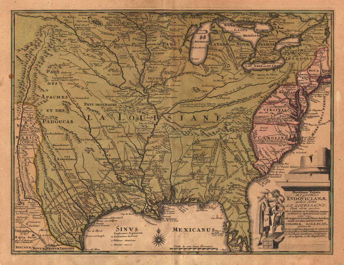
Novissima Tabula Regionis Ludovicianae ...
€865.00
Prices incl. VAT plus shipping costs
This item is sold. Please contact us if you are searching for this item.
Eigenschaften
- Published: C. Weigel , Nürnberg
- Published date: 1719
- Technique: Copper engraving / Original color.
- Type: Antique Map, map
- Issue date: 1719
- Category: Louisiana
- Size: 312 by 402mm (12 by 15 inches).
- Stock number: 19991
- Condition: In very good condition. 312 by 402mm (12 by 15 inches).
Article description
Article description
Original antique copper engraving, hand colored in outline and wash when published. Rare map of Northeast America by Christoph Weigel. Shows the entire eastern part of the United States to today's Texas. The map is based on the important map of G. de l'Isle from 1718. The Gulf region and Mississippi are shown in great detail. The exploration routes of Denis, Tonty, Cavelier, Moscoso and De Soto are shown. The title cartouche shows two people with a chest full of coins and a share certificate, based on the famous Mississippi Bubble. From a comfortable school and travel atlas also Atlas scholasticus et itinerarius by Christoph Weigel. Weigel published the famous travel atlas in collaboration with Professor Johann David Köhler. Johann Christoph Weigel, known as Christoph Weigel the Elder (9 November 1654 – 5 February 1725), was a German engraver, art dealer and publisher. He was born at Redwitz, Free imperial city of Eger in Egerland, and died in Nuremberg, aged 70. The cartographer Weigel worked around 1719 in Nürnberg and his maps are showing the typical style of this period in map making in Southern German. He worked very close as with Johann B. Homann in Nürnberg. All his maps were hand colored in outline and decorative body color immediatelly in his printing house, after they were printed.You might also be interested in the following products
 Johnson's Georgia...
 Lithograph, hand-colored in outline by Johnson & Browning, published 1859 by New York. Image size: 395 by 560mm...
€65.00
 Gray's New...
 Lithograph, original color in outline by Gray, Frank, published 1884 by O.W. Gray & Son, Philadelphia. Image...
€70.00
 Amér.Sep....
 Lithograph, hand-colored in outline by Vandermaelen, Phillippe Marie, published 1825 by Brussels. Image size: 463 by...
€177.00
 L'Ancien et...
 Copper Engraving, uncolored by Bonne, Rigobert, published 1787 by M. Bonne, Paris. Image size: 346 by 235mm (13 by 9...
€195.00
Recently viewed products