Marzolla, Benedetto
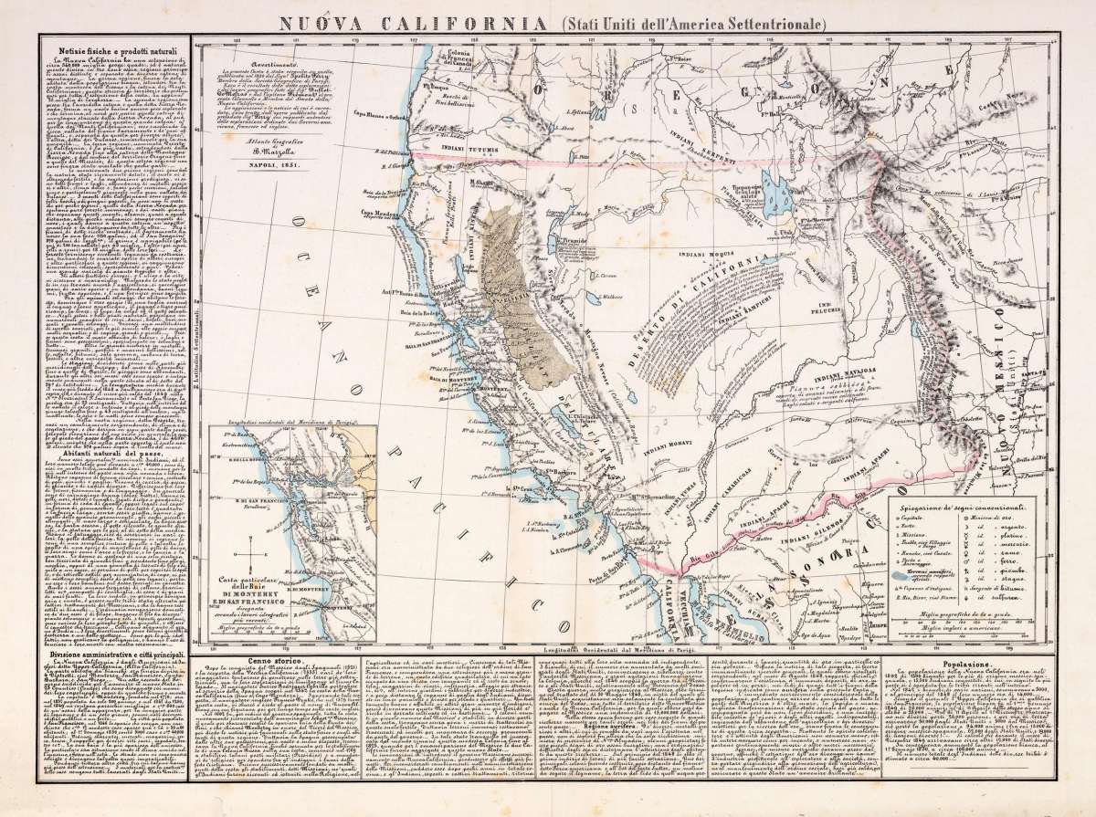
Nuova California (Stati Uniti dell´ America Settentrionale)
Prices incl. VAT plus shipping costs
This item is sold. Please contact us if you are searching for this item.
- Published: Naples
- Published date: 1851
- Type: Antique Map
- Issue date: 1851
- Technique: Lithograph / Original color.
- Category: California
- Size: 349 by 490mm (13¾ by 19¼ inches).
- Bibliography: Wheat 714 (illustrated).
- Stock number: 19202
- Condition: In excellent condition. Two small minor marginal mendings.
Article description
Lithograph, hand colored in outline when published. A very rare map of California and its neighbouring Western states Oregon & New Mexico towards Santa Fé. It shows California from the Rocky Mountains across the desert towards the Pacific Ocean. In the map 'Gold Rush areas' and mines are marked. It is as well equipped with an extensive table of explanations and a mileage scale. The map is surrounded on two sides with extensive Italian describing text on the history and the population of California. Benedetto Marzolla based this rare and unusual map on the California on the map of 1850 by Hippolyte Ferry, who based the most parts of his map on geographic information by General Fremont and Duflot du Mofras. The inset map in the lower corner, showing the area of San Francisco and Monterey, is based on H. Ferry. The map is rich in details and extensive text notes like in the 'Deserto Di California', which are describing the passage in 1843/44 of General Fremont through that region. Also the wagon route from Santa Fe to the West Coast is marked in the map. Further on the map is rich in detailed place names of cities, villages, early settlements, forts, trails, gold regions, mines and missions. Mountain chains and rivers are as well named. Further on the map provides information on the various Indian Tribes with their occurrence. The map was published in Benedetto Marzolla's rare atlas 'Atlante Geografico ...'. The individual map or the atlas is hardly seen. An interesting collector's item for the 'California Gold Rush' and California and the west.
Wheat 714 (illustrated).
You might also be interested in the following products
 Views from Mt....
  Amér. Sep. Ile De...
  Amer. Sep. Grand...
  Amèr. Sep. Partie...