[Staehlin, Jacob von]
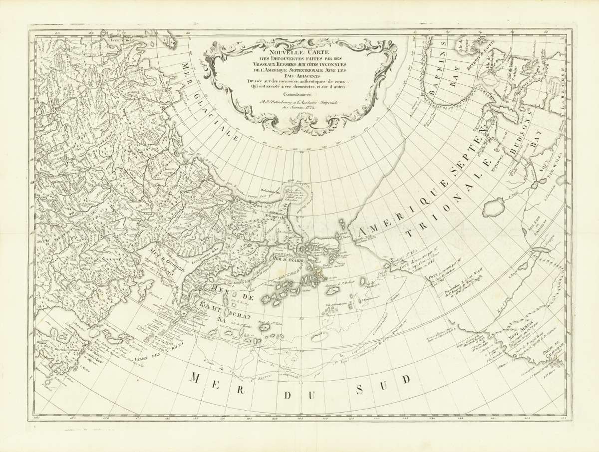
Nouvelle Carte des Découvertes Faites Par des Vaisseaux Russiens aux cótes inconnues de L´Amérique septentrionale...
[New Map of discoveries made By Russian vessels to the unknown coasts of North America with the adiacent countries. Built on authentic memories of those. Who attended these discoveries, and other knowledge.]
Prices incl. VAT plus shipping costs
This item is sold. Please contact us if you are searching for this item.
- Published: Petersburg
- Published date: 1773
- Technique: Copper engraving / Uncolored
- Type: map
- Issue date: 1773
- Category: Pacific Northwest
- Size: 465 by 645mm (18¼ by 25½ inches).
- Stock number: 31585
- Condition: In very good condition.
Article description
Original copper engraving, uncolored as published. Original antique map, engraved by Jacob van Staehlin (1709-1785) and issued first by the Imperial Academy of Sciences in St. Petersburg in 1758. Staehlin was an engraver and cartographer from southwest Germany, born in Memmingen. in 1735, was called to St. Petersburg to work for the St. Petersburg Academy. In 1735 he went to the Imperial Academy of Sciences to St. Petersburg and became a professor in 1738 and in 1741 he took over the Department of Art at the Academy. This is the edition republished 1773 by the Imperial Academy of Sciences. The map was updated from Fredrick Muller's 1754 map of the same region illustrating the findings of Vitus Bering's Great Northern Expedition.Map of Northwest America and the Russian Far East, including Bering Strait, showing exploration routes from Bering, Chirikov, and other Russian explorers. The map depicts from eastern Nowaja Semlja to Hudson Bay and from the Arctic Ocean to California and Honshu, Japan. One of the most important individual results of the expedition was the mapping and representation of the northeastern part of Asia. In 1754, the Department of Geography of the Saint Petersburg Academy of Sciences published a map entitled Nouvelle Carte des Découvertes faites par des Vaisseaux Russiens, which also recorded the shipping routes Vitus Berings and Alexei Ilyich Tschirikows. The newly acquired geographic information was very well received across Europe and spread quickly. The map was published with the usual vertical centre fold in the middle, which is of course visible. In addition the map was at an earlier date also folded horizontal, which is slightly visible. There are further two minor mended splits at the right and left side in the blank margins outside the image of the map. A small, very light stain or spot hardly visible is in the centre of the map below the words 'MER de ANADIR'. In the lower blank margin (in the middle, on the right side close to the centre fold) is a small mended tear in the blank margin, also a small printer's crease between the engraved numbers 205 and 210 is next to it. The map is in its original condition as published with full margins. It was not restored or cleaned. The impression of the printing is strong and it is printed on very good paper.
[New Map of discoveries made By Russian vessels to the unknown coasts of North America with the adiacent countries. Built on authentic memories of those. Who attended these discoveries, and other knowledge.]
You might also be interested in the following products
 Views from Mt....
  Amér. Sep. Ile De...
  Amer. Sep. Grand...
  Amèr. Sep. Partie...