Petermann, A.
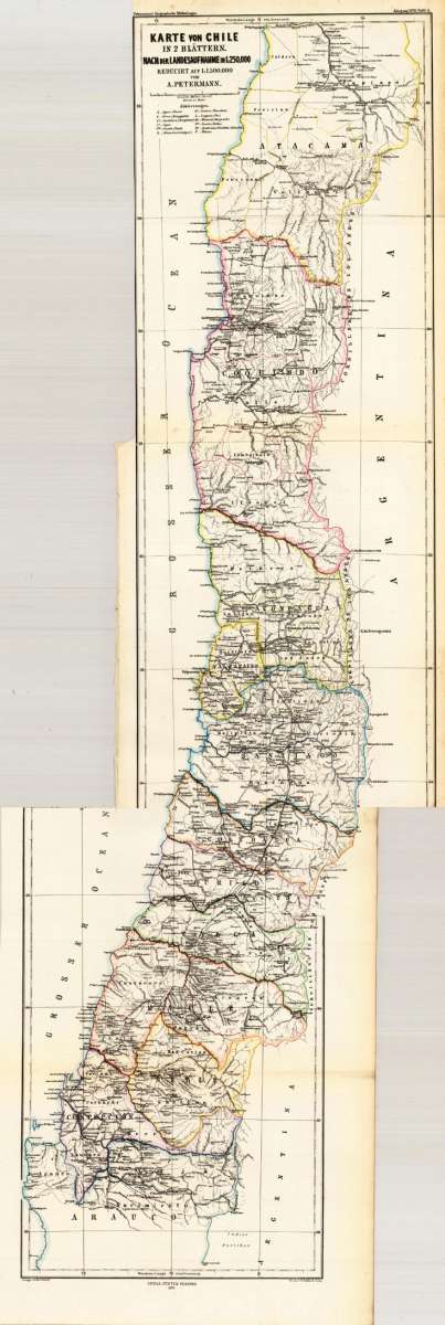
Karte von Chile in 2 Blättern. Nach der Landesaufnahme in 1:250.000 Reducirt auf 1:1.500.000 von A. Petermann.
Petermann, A. – Chile · Lithograph, Printed in Colours · Petermanns Geographische Mitteilungen, Gotha · 1870
Eigenschaften
- Published: Gotha
- Published date: 1870
- Technique: Lithograph / Original color.
- Issue date: 1870
- Category: Chile
- Type: map
- Size: 840 by 200mm (33 by 7¾ inches).
- Bibliography: J. Smits Petermann's Maps #367;
- Stock number: 26547
- Condition: In excellent condition. The map was originally published folded, so that the old folds are still slightly visible.
Article description
Article description
Original antique lithograph, printed in colours, published by Justus Perthes in Gotha for 'Petermanns Geographische Mitteilungen', 1870. Lithograph, original color in outline. Sheet: 840 by 200mm (33 by 7¾ inches).. August Heinrich Petermann (1822–1878) was one of the most important German cartographers and geographers of the 19th century. Born in Bleicherode, Saxony, he trained at the Geographische Kunstschule in Potsdam under Heinrich Berghaus — himself a leading student of Alexander von Humboldt. After a formative decade in Edinburgh and London (1845–1854), where he gained broad experience in the commercial and scientific aspects of cartography, Petermann returned to Gotha and joined the Justus Perthes publishing house. In 1855 he founded 'Petermanns Geographische Mitteilungen' (PGM), which swiftly became one of the world's foremost geographical journals — the definitive record of the great age of exploration and discovery. Petermann personally produced over 500 maps and signed 226 articles in PGM, ranging across Africa, the Polar regions, Asia, and the history and practice of cartography. In 1902, the eminent British cartographer J. G. Bartholomew wrote: 'No one has done more than he to advance modern cartography.' His maps are held in major institutions worldwide, including the Library of Congress, the British Library, and the Bibliothèque nationale de France. This lithograph, printed in colours from 'Petermanns Geographische Mitteilungen' focuses on Chile. Published in 1870 by Justus Perthes, Gotha, it exemplifies Petermann's exacting approach: drawing on the latest expedition reports, survey data, and geographical literature to produce maps of unrivalled scientific accuracy for their time. PGM maps from this period are highly sought after by collectors of exploration history, scientific cartography, and antique maps of the regions they depict. Dekorative alte Landkarte in 2 Blättern von Chile in Südamerika. Dargestellt wird Chile von der südlichen Provinz Arauco bis hin zur nördlichen Provinz Atacama. Gezeigt wird das Land Chile aufgeteilt in seine einzelnen Provinzen. Die politischen Grenzen sind in einem zeitgenössischem Grenzkolorit dargestellt. Mit vielen detaillierten Ortsangaben, eingezeichneten Namen von Provinzen und Gebieten, sowie Flüßen, Bergen, Seen und einigen Eisenbahnstrecken. Links oben beim Titel ein kleiner Meilenzeiger, sowie eine Legende mit Erklärungen zur Landkarte.Petermann, A. – Chile · Lithograph, Printed in Colours · Petermanns Geographische Mitteilungen, Gotha · 1870
J. Smits Petermann's Maps #367;
You might also be interested in the following products
 Guiana sive...
 Copper engraving, hand colored in outline and wash when published. French text edition. Decorative map extending...
€325.00
 Specialkarte vom...
 Lithograph, printed in colors when published. Detailled map, showing the Chonos Archipel from the gulf of Penas with...
€132.00

 Süd America. Nach...
 Steel engraving, hand colored in outline when published. An antique, fine decorative map of South America with many...
€114.00
Recently viewed products