Ortelius, Abraham
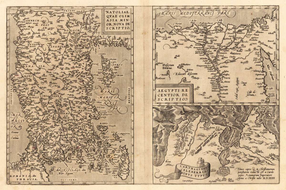
Natoliae, Qvae Olim Asia Min:or, Nova De:scriptio - Aegypti Recentior Descriptio. - Carthaginis Celeberrimi Sinvs Typus.
Eigenschaften
- Published: Platin , Antwerp
- Published date: 1572
- Type: Antique Map, map
- Technique: Copper engraving / Uncolored
- Issue date: 1572/73
- Category: Asia Minor, Egypt & Carthago
- Size: 321 by 492mm (12 by 19 inches).
- Bibliography: Broe. 174.
- Stock number: 23534
- Condition: In excellent condition. 321 by 492mm (12 by 19 inches).
Article description
Article description
Original copper engraving, uncolored as published 1572/73 in a German text edition of the 'Theatrum Orbis Terrarum'. The map shows three maps on one double page, each of them with a title cartouche. Asia Minor is shown with the east to the north oriented with Cyprus in the eastern Mediterranean. The other small map of Egypt is showing mainly the Nile delta with the neighboring area. The third map shows the surroundings of Tunis (Carthago). Villages and towns are shown as miniature views. Moreover the maps are ornated with ships. Abraham Ortelius received the cartographic sources for those maps by Gastaldi and Forlani, 1564, for Egypt by Forlani 1566 and Carthago after an Italian one sheet source dated 1535 (Broe. 174). Ortelius was born on 14 April 1527 in the city of Antwerp, which was then in the Habsburg Netherlands (modern-day Belgium). The Orthellius family were originally from Augsburg, a Free imperial city of the Holy Roman Empire. In 1535, the family had fallen under suspicion of Protestantism. Following the death of Ortelius's father, his uncle Jacobus van Meteren returned from religious exile in England to take care of Ortelius. Abraham remained close to his cousin Emanuel van Meteren, who would later move to London. In 1575 he was appointed geographer to the king of Spain, Philip II, on the recommendation of Arias Montanus, who vouched for his orthodoxy. He travelled extensively in Europe and is specifically known to have traveled throughout the Seventeen Provinces; in southern, western, northern, and eastern Germany (e.g., 1560, 1575–1576); France (1559–1560); England and Ireland (1576); and Italy (1578, and perhaps twice or thrice between 1550 and 1558). Beginning as a map-engraver, in 1547 he entered the Antwerp Guild of Saint Luke as an illuminator of maps. He supplemented his income trading in books, prints, and maps, and his journeys included yearly visits to the Frankfurt book and print fair, where he met Gerardus Mercator in 1554. In 1560, however, when travelling with Mercator to Trier, Lorraine, and Poitiers, he seems to have been attracted, largely by Mercator's influence, towards the career of a scientific geographer. (Wikipedia)Broe. 174.
You might also be interested in the following products
 Tabula Asiae I...
 Fine copper-engraved map, printed into the full text page, published in 'Geografia ... Universale de la...
€145.00
") Tabula Asiae V...
Tabula Asiae V... Fine copper-engraved map, printed into the full text page, published in 'Geografia ... Universale de la...
€145.00
 Europaeische und...
 Original antique copper engraving, hand colored in outline and wash, when published. Decorative map showing the...
€275.00
 Asia Minor,...
 Steel engraving, hand colored in outline when published. This antique map shows Asia Minor with a small part of...
€50.00
Recently viewed products