Bussemacher, Johann
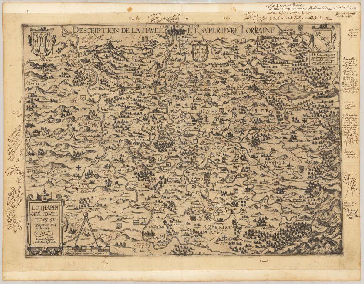
Lotharingiae Ducatus superioris vera delineatio. Coloniae Agrippinae excudit Ioann Bussemacher
€545.00
Prices incl. VAT plus shipping costs
This item is sold. Please contact us if you are searching for this item.
Eigenschaften
- Published: Köln
- Published date: 1600
- Technique: Copper engraving / Uncolored.
- Type: map
- Issue date: 1600
- Category: Lothringia
- Size: 36 x 49 cm (14.25 x 19,25 inches).
- Stock number: 34779
- Condition: A fine and dark impression of this scarce map.
Article description
Article description
Copper engraving, uncolored as published. A rare and separately published map by the famous German map maker Johannes Bussemacher from Cologne. The map shows very detailled the region south of Metz towards Epinal close to the Vogese mountains. Finely engraved with countless coats of arms, mostly engraved on the map close to castles or place names. Villages, cities and castles are mostly engraved as miniature city cviews, woods mountain, lakes and rivers are finely depicted on the map. The lower left corner with a renaissance title cartouche, mileage scale and a circle. In the upper corner on the left side the coat of arms of the Duc de bar and in the upper right corner a coat of arms with a dedication to the duc or the house of Lothringia. The map was probably bound prior into a composite atlas, the top and bottom margins were added with paper stripes, these blank margins surrounding the actual map are with numerous old inscriptions in ink, the notes are pointing to various places on the map. Old folds are visible (size of the sheet 430 x 553 mm).You might also be interested in the following products
 Artesia
 Original antique copper engraving, hand coloured when published, depicting Artois. Published by M. Seutter, Augsburg,...
€145.00
 Artesia. Iacobo...
 Original antique copper engraving, hand coloured when published, depicting Artois. Published in Antwerpen, 1588....
€295.00
 Elsass
 Original antique copper engraving, hand coloured when published, depicting Elsass - Alsatia. Published by Jodocus...
€240.00
 Li contorni di...
 Original antique copper engraving, hand coloured when published, depicting Paris. Published by Antonio Zatta.,...
€180.00
Recently viewed products