Ortelius, Abraham
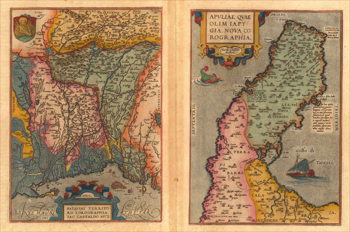
Patavini Territorii Corographia Iac Castaldo Auct. Apuliae Quae Olim Iapy: Gia. Nova Corographia . Jacobo Castaldo...
€380.00
Prices incl. VAT plus shipping costs
This item is sold. Please contact us if you are searching for this item.
Eigenschaften
- Published: Antwerpen
- Published date: 1588
- Type: Antique Map, map
- Issue date: 1588
- Technique: Copper engraving / later handcolor
- Category: Padua & Apuliae
- Size: 308 by 220mm (12 by 8 inches).
- Bibliography: Broe. 121.
- Stock number: 17425
- Condition: A very good example in excellent condition. 308 by 220mm (12 by 8 inches).
Article description
Article description
Original antique copper engraving, published 1598 in a French text edition of the 'Theatrum Orbis Terrarum'. Finely hand colored in wash and outline. Two maps on one doublesheet. Puglia is oriented to the east and Calabria is oriented to the north. Villages and towns are shown as miniature views. Ortelius was born on 14 April 1527 in the city of Antwerp, which was then in the Habsburg Netherlands (modern-day Belgium). The Orthellius family were originally from Augsburg, a Free imperial city of the Holy Roman Empire. In 1535, the family had fallen under suspicion of Protestantism. Following the death of Ortelius's father, his uncle Jacobus van Meteren returned from religious exile in England to take care of Ortelius. Abraham remained close to his cousin Emanuel van Meteren, who would later move to London. In 1575 he was appointed geographer to the king of Spain, Philip II, on the recommendation of Arias Montanus, who vouched for his orthodoxy. He travelled extensively in Europe and is specifically known to have traveled throughout the Seventeen Provinces; in southern, western, northern, and eastern Germany (e.g., 1560, 1575–1576); France (1559–1560); England and Ireland (1576); and Italy (1578, and perhaps twice or thrice between 1550 and 1558). Beginning as a map-engraver, in 1547 he entered the Antwerp Guild of Saint Luke as an illuminator of maps. He supplemented his income trading in books, prints, and maps, and his journeys included yearly visits to the Frankfurt book and print fair, where he met Gerardus Mercator in 1554. In 1560, however, when travelling with Mercator to Trier, Lorraine, and Poitiers, he seems to have been attracted, largely by Mercator's influence, towards the career of a scientific geographer. (Wikipedia)Broe. 121.
You might also be interested in the following products
 Pedemontanae...
 Original antique copper engraving, uncolored, from the 'Theatrum Orbis Terrarum' by Abraham Ortelius, the...
€650.00
 Naples & Sicily
 Original antique lithograph, published 1852. Depicting Kingdom of Naples, this map is a fine example of 0s European...
€145.00
 Milane States
 Original antique hand-colored lithograph, published 1852. Depicting Milan & Lombardy, this map is a fine example...
€140.00
 Les Environs De...
 Original antique hand-colored copper engraving, published 1700. Depicting Kingdom of Naples, this map is a fine...
€170.00
Recently viewed products