Jansonnius, Joan.
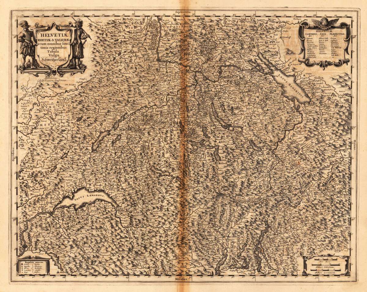
Helvetiae Rhetiae & Valesiae cum omnibus finitimis regionibus Tabula Vulgo Schweitzerland
€540.00
Prices incl. VAT plus shipping costs
This item is sold. Please contact us if you are searching for this item.
Eigenschaften
- Published: Amsterdam
- Published date: 1646
- Technique: Copper engraving / Original color.
- Type: Antique Map, map
- Category: Switzerland
- Issue date: 1646-57
- Size: 420 by 530mm (16 by 20 inches).
- Bibliography: Koeman I [4900:1C] Latin Ttt
- Stock number: 23769
- Condition: In excellent condition. A small tear at the bottom. Not affecting the image. 420 by 530mm (16 by 20 inches).
Article description
Article description
Original antique copper engraving, hand colored in outline when published. Latin edition. Switzerland is represented around 1655 by the Dutch cartographer Johannes Jansonnius. Engraved with a decorative title cartouche at the top left, and decorated with a mileage scale and privilege in the lower margin. Johannes Janssonius (1588, Arnhem – buried July 11, 1664, Amsterdam) (born Jan Janszoon, in English also Jan Jansson) was a Dutch cartographer and publisher who lived and worked in Amsterdam in the 17th century. Janssonius was born in Arnhem, the son of Jan Janszoon the Elder,[1] a publisher and bookseller. In 1612 he married Elisabeth de Hondt, the daughter of Jodocus Hondius. He produced his first maps in 1616 of France and Italy. In 1623 Janssonius owned a bookstore in Frankfurt am Main, later also in Danzig, Stockholm, Copenhagen, Berlin, Königsberg, Geneva and Lyon. Elisabeth Hondius died in 1627 and he remarried Elisabeth Carlier in 1629. In the 1630s he formed a partnership with his brother in law Henricus Hondius, and together they published atlases as Mercator/Hondius/Janssonius. Under the leadership of Janssonius the Hondius Atlas was steadily enlarged. Renamed Atlas Novus, it had three volumes in 1638, one fully dedicated to Italy. In 1646, a fourth volume came out with "English County Maps", a year after a similar issue by Joan Blaeu. Janssonius' maps are similar to those of Blaeu, and he is often accused of copying from his rival, but many of his maps predate those of Blaeu and/or covered different regions. By 1660, at which point the atlas bore the appropriate name "Atlas Major", there were 11 volumes, containing the work of about a hundred credited authors and engravers. It included a description of "most of the cities of the world" (Townatlas), of the waterworld (Atlas Maritimus in 33 maps), and of the Ancient World (60 maps). The eleventh volume was the Atlas of the Heavens by Andreas Cellarius. Editions were printed in Dutch, Latin, French, and a few times in German. After Janssonius's death, the publishing company was continued by his son-in law, Johannes van Waesbergen. The London bookseller Moses Pitt attempted publication of the Atlas Major in English, but ran out of resources after the fourth volume in 1683. (Wikipedia)Koeman I [4900:1C] Latin Ttt
You might also be interested in the following products
 Argow
Argow Original antique copper engraving, hand colored in outline when published. A highly detailed 17th century map of...
€295.00
 Argow
Argow Original antique copper engraving, uncolored. Published in the first Cloppenburgh edition of Gerhard Mercator's...
€120.00
 Von dem Berg Jura...
 Woodcut published 1628 in the 'Cosmographia' by Sebastian Münster. Small woodcut of the mountain Jurasso.
€30.00
 Von dem Bergwerck...
 Woodcut published 1628 in the 'Cosmographia' by Sebastian Münster. Woodcut map showing the...
€50.00
Recently viewed products