Levasseur, V.
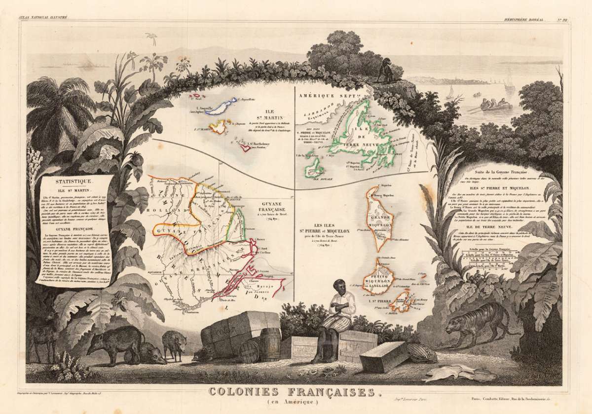
Colonies Francaises (en Amerique) Suite de la Guyane Francaise, Iles St. Pierre et Miquelon, Ile de Terre Neuve, Ile...
Eigenschaften
- Published: A. Combette , Paris
- Published date: 1856
- Type: Antique Map, map
- Issue date: 1856
- Technique: Copper engraving / Outline color.
- Category: Guiana - St Martin
- Size: 290 by 425mm (11½ by 16¾ inches).
- Stock number: 29239
- Condition: Die dekorative antike Landkarte zeigt in der Mitte des Kartenbildes die Inseln ,St. Martin, Neufundland, Französisch Guayana, Grande Miquelon, Langlade und Saint-Pierre. Eingerahmt wird die Landkarte von Tabakblättern, vielen Pflanzen und Tieren. In der rechten oberen Ecke wird in der Ferne eine bewohnte Insel gezeigt und im Vordergrund einige Segel- und Ruderboote mit Personen. Im unteren Bildbereich sieht man den Handel mit Baumwolle, Tabak, Kaffee und etliche Wildschweine, Fische u.a. Auf beiden Seiten der Landkarte befindet jeweils eine Kartusche mit der Statistik über die verschiedenen Inseln. 290 by 425mm (11½ by 16¾ inches).
Article description
Article description
Original engraved map, hand colored in outline when published in V. Levasseur's atlas of French departments. The very decorative antique map shows in the centre the islands St. Martin, Newfoundland, French Guiana, Grande Miquelon, Langlade and Saint-Pierre. Surrounded is the map by tabacco leaves, many plants and animals. In the upper right corner a scene of an inhabitated island in the distance with sailingboats and persons in the foreground. At the bottom allegories on the trading with cotton, tabacco and coffee, further wildboars, fiish, etc. On both sides cartouches with descriptive text or statistic tables.You might also be interested in the following products
 Pas kaart Van de...
 Original antique copper engraving, finely hand colored in outline and wash, probably later hand color. Detailed...
€750.00
 Isle de la...
 Copper engraving, hand colored in outlineand wash. Detailed map showing detailed the Islands of Martinique,...
€95.00
 Isle De La...
 Copper-engraving, handcolored in outline, when published. A fine engraved, detailed map on the island of Martinique...
€136.00
 Martinico to...
 Decorative doublepage handcolored lithograph, showing decorative in a large scale the Island of Martinico, with an...
€268.00
Recently viewed products