Zatta, Antonio
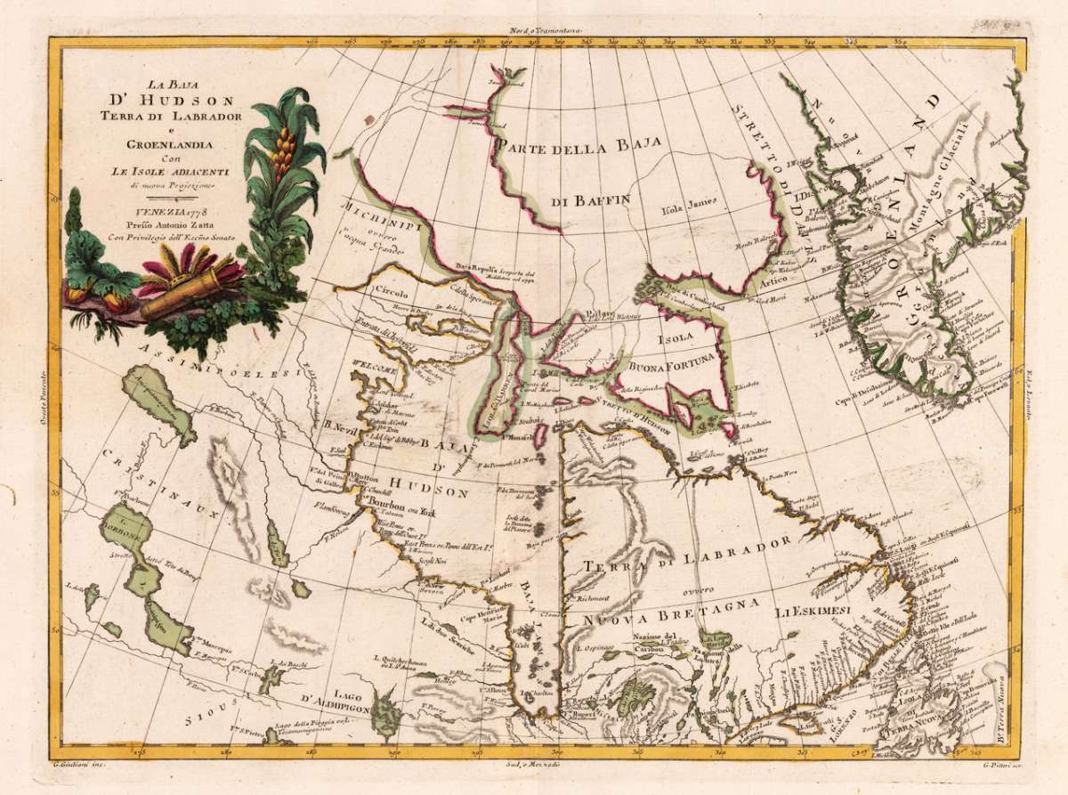
La Baja d' Hudson Terra di Labrador e Groenlandia con le Isole Adiacenti di nouva Projezione - Venezia 1778 Presso...
Zatta, Antonio – La Baja d' Hudson Terra di Labrador e Groenlandia con l... · Antique Map, Copper Engraving · 302 x 408mm · Antonio Zatta., Venice 1778
Eigenschaften
- Published: Antonio Zatta. , Venice
- Published date: 1778
- Technique: Copper engraving / Original color.
- Type: Antique Map, map
- Issue date: 1778
- Category: Hudson & Labrador
- Size: 302 by 408mm (12 by 16 inches).
- Stock number: 21259
- Condition: In excellent condition. 302 by 408mm (12 by 16 inches).
Article description
Article description
Copper Engraving, original color in outline by Zatta, Antonio, published 1778 by Antonio Zatta, Venice. Image size: 302 by 408mm (12 by 16 inches). From Zatta's Atlante Novissimo — one of the most important Italian atlases of the 18th century. Antonio Zatta (c.1722–1804) was a prominent Venetian cartographer, engraver, and publisher who flourished between 1757 and 1797. He was awarded the title of Official Geographer to the Republic of Venice, reflecting the high esteem in which his work was held. Zatta is best known for his four-volume Atlante Novissimo (1779–1785), one of the most important Italian atlases of the 18th century. The atlas incorporated the most recent geographical discoveries, including the Pacific islands visited by Captain Cook. His 12-sheet map of the United States (1778), based on John Mitchell's landmark map, is considered one of the finest re-engravings of that seminal work. Zatta's maps are celebrated for their fine craftsmanship, aesthetic quality, and their importance as primary documents of late 18th-century geographical knowledge, making them among the most prized Italian antique maps for collectors today. This old colored antique map shows in the middle the Hudson Bay Area. Greenland is in the upper right corner and on the left side is the title surounded from green leaves, indian jewelry with arrow and bow. In excellent condition.Zatta, Antonio – La Baja d' Hudson Terra di Labrador e Groenlandia con l... · Antique Map, Copper Engraving · 302 x 408mm · Antonio Zatta., Venice 1778
You might also be interested in the following products
 Pascaarte vande...
 Copper Engraving, uncolored by van Keulen, Joan, published 1684-1704 by Johannes van Keulen, Amsterdam. Image size:...
€1,100.00
 Britisches Nord -...
 Lithograph, original color in outline by Flemming, Carl, published 1845 - 50 by C. Flemming, Glogau. Image size: 310...
€84.00
 Johnson's...
 Lithograph, original color in outline by Johnson & Ward, published 1865 by Johnson & Ward, New York. Image...
€45.00
 Karte von den...
 Copper Engraving, uncolored by Bellin, Nicolaus, published 1753 by Merkur, Leipzig. Image size: 205 by 267mm (8 by 10...
€84.00
Recently viewed products