Goos, Pieter
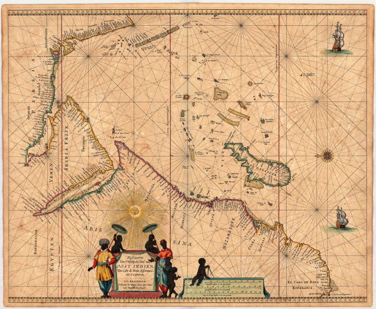
Pascaerte Van't Westelycke Deel van Oost Indien, Van Cabo de Bona Esperanca, tot C. Comorin. Tot Amsterdam,...
Eigenschaften
- Published: Pieter Goos , Amsterdam
- Published date: 1666
- Technique: Copper engraving / Original color.
- Type: Antique Map, map
- Issue date: 1666
- Category: Arabia & the Indian Ocean
- Size: 445 by 542mm (17½ by 21¼ inches).
- Bibliography: Koeman IV (Maritime Atlases), Goos pp. 190 ff.
- Stock number: 23743
- Condition: Printed on double thick paper. The paper slightly toned or stained. A small clear tiny mended split at the lower centre fold. In very good to excellent condition. 445 by 542mm (17½ by 21¼ inches).
Article description
Article description
Copper engraving, finely hand colored in outline, when published. Partially heightened in gold. The map of the 'Indian Ocean' is orientated with the north to the left. The highly decorative chart shows the East African coast, Arabia, Madagascar and the islands of the Indian Ocean with the Seychelles and the Maldives. The sea is ornated with two sailing ships, a compass rose, at the bottom a decorative title cartouche, surrounded by African natives, next to it a mileage scale with Dutch, Spanish and English distances in nautical miles. In this period the Dutch East India Company was leading in trading in Asia and exploring the Indian Ocean and Southeast Asia. Pieter Goos was 'one of the best known maritime booksellers of Amsterdam' (Koeman), he published a number of different sea-atlases or pilot books, his work was very much derivative. With his 'Zee-Atlas' he relied heavily on Hendrick Doncker's 'Zee-Atlas' of 1659. Our example of Pieter Goos chart 'Pascaerte Van't Westelycke Deel van Oost Indien...' was published in an early composit sea-atlas published probably around 1665/66. This map is printed on excellent thick double paper, it stands out through the highly decorative hand colors and the partially heightening of gold in title cartouches, mileage scales, compass roses or other places. P. Goos is well known for his quality of the engraving, as his father also was a skilled engraver, he always tried to produce visually appealing sea charts.Koeman IV (Maritime Atlases), Goos pp. 190 ff.
You might also be interested in the following products
 Moluccae Insulae...
 Original antique copper engraving, hand colored in outline and wash when published. A highly decorative map of the...
€550.00
 Pascaert van...
 Original antique copper engraving, uncolored as published. Detailed chart of the Northeastern part of Canada,...
€1,750.00
 Pascaarte vande...
 Copper Engraving, uncolored by van Keulen, Joan, published 1684-1704 by Johannes van Keulen, Amsterdam. Image size:...
€1,100.00
 Guiana sive...
 Copper engraving, hand colored in outline and wash when published. French text edition. Decorative map extending...
€325.00
Recently viewed products