Seutter, Matthäus
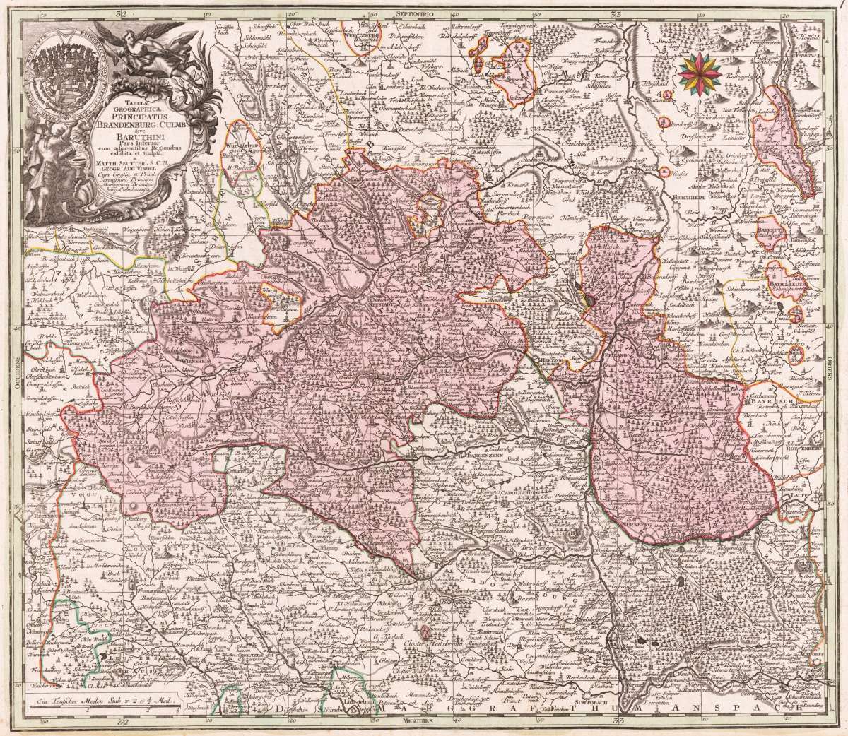
Tabulae Geographicae. Principatus Brandbenburg: Culmb: sive Baruthini pars Inferior cum adjacentibus Regionibus...
Tabulae Geographicae. Principatus Brandbenburg: Culmb: sive Baruthini pars Inferior cum adjacentibus Regionibus exhibita et Sculpta - Matth. Seutter, S.C.M....
Eigenschaften
- Published: Augsburg
- Published date: 1720
- Technique: Copper engraving / Original color.
- Category: Franconia
- Issue date: 1720 - 30
- Type: map
- Size: 498 by 570mm (19 by 22 inches).
- Stock number: 22878
- Condition: In excellent condition.
Article description
Article description
Hand-Colored Original Copperplate Engraving by Matthäus Seutter, depicting Tabulae Geographicae. Principatus Brandbenburg: Culmb: sive Baruthini pars Inferior cum adjacentibus Regionibus exhibita et Sculpta - Matth. Seutter, S.C.M. Geogr. Aug. Vindel. Cum Gratia et Privil: Serenißimi Principis Marggravü Brandenburg Culmbacensis.. Published Augsburg, M. Seutter, 1720. Sheet: 498 by 570mm (19 by 22 inches).. A fine and original hand-colored example of Seutter's celebrated cartographic work, documenting this region of Germany with the precision and decorative artistry characteristic of the 17200s. Matthaus Seutter (1678-1757) was one of the most prolific German cartographers of the 18th century, based in Augsburg. He trained as an engraver under Johann Baptist Homann in Nuremberg before establishing his own publishing firm in Augsburg around 1717. His skill and output were so impressive that Holy Roman Emperor Charles VI appointed him Imperial Geographer in 1732 -- a title he shared with his former master Homann. Seutter produced over 500 maps during his career, known for their richly detailed cartouches, decorative borders, and brilliant hand coloring. His work is held in collections at the Augsburg City Library, the Staatsbibliothek Berlin, and major museums across Europe. This original copperplate engraving, with original hand coloring depicts the region of Tabulae Geographicae. Principatus Brandbenburg: Culmb: sive Baruthini pars Inferior cum adjacentibus Regionibus exhibita et Sculpta - Matth. Seutter, S.C.M. Geogr. Aug. Vindel. Cum Gratia et Privil: Serenißimi Principis Marggravü Brandenburg Culmbacensis., published in Augsburg, M. Seutter, 1720 - 30. A distance scale is incorporated within the cartouche or alongside it. The map records the political and geographic boundaries of the region as understood in 1720 - 30, offering a fascinating window into the history of German territorial organization. Sheet measures 498 by 570mm (19 by 22 inches).. In good condition overall, with minor signs of age appropriate for a 18th-century engraving. Ready to frame.Tabulae Geographicae. Principatus Brandbenburg: Culmb: sive Baruthini pars Inferior cum adjacentibus Regionibus exhibita et Sculpta - Matth. Seutter, S.C.M....
You might also be interested in the following products
 Circulus...
 Hand-Colored Original Copperplate Engraving by Christoph Weigel, depicting Circulus Franconicus ad Occidentem vergens...
€195.00
 Die Ludwigsbrücke...
 Hand-Colored Original Steel Engraving by Ludwig Lange, depicting Die Ludwigsbrücke in Bamberg.. Published München, G....
€40.00
 Der Dom zu Bamberg.
 Hand-Colored Original Steel Engraving by Ludwig Lange, depicting Der Dom zu Bamberg.. Published München, G. G. Lange,...
€75.00
 Schleusse am...
 Hand-Colored Original Steel Engraving by A. Marx, depicting Schleusse am Malckerspund in Bamberg.. Published...
€110.00
Recently viewed products