de Fer, Nicolaus
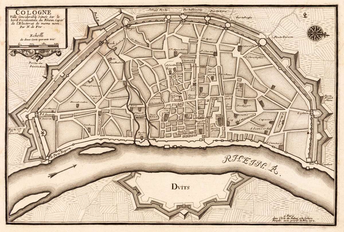
Cologne
Cologne - Nicolaus de Fer ∑ Hand-Colored Original Copperplate Engraving ∑ Paris 1702
Eigenschaften
- Published: N. de Fer , Paris
- Published date: 1702
- Type: Antique Map, map
- Technique: Copper engraving / Uncolored
- Issue date: 1702
- Category: City Plan of Cologne
- Size: 232 by 349mm (9 by 13 inches).
- Stock number: 19554
- Condition: One old crease in the paper, else in very good condition. 232 by 349mm (9 by 13 inches).
Article description
Article description
Hand-Colored Original Copperplate Engraving by Nicolaus de Fer, depicting Cologne. Published Paris, N. de Fer, 1702. Sheet: 232 by 349mm (9 by 13 inches).. A fine and original hand-colored example of de Fer's celebrated cartographic work, documenting this region of Germany with the precision and decorative artistry characteristic of the 17000s. Nicolaus de Fer was a cartographer active in the 1700s, working in the tradition of European copper-engraved cartography. Their maps are valued by collectors for their historical accuracy and decorative quality. This original copperplate engraving, with original hand coloring depicts the region of Cologne, published in Paris, N. de Fer, 1702. The map records the political and geographic boundaries of the region as understood in 1702, offering a fascinating window into the history of German territorial organization. Sheet measures 232 by 349mm (9 by 13 inches).. In excellent condition. Ready to frame.Cologne - Nicolaus de Fer ∑ Hand-Colored Original Copperplate Engraving ∑ Paris 1702
You might also be interested in the following products
") Kleve (Herzogtum)
Kleve (Herzogtum) Hand-Colored Original Copperplate Engraving by Guijelmus Blaeu & Joan., depicting Kleve (Herzogtum). Published...
€380.00
 Köln
Köln Hand-Colored Original Copperplate Engraving by Matthäus Seutter, depicting Köln. Published Augsburg, 1730. Sheet: 503...
€380.00
 Paderborn
 Hand-Colored Original Copperplate Engraving by Matthäus Seutter, depicting Paderborn. Published Augsburg, Matthäus...
€675.00
 Clivia Ducatus et...
 Hand-Colored Original Copperplate Engraving by Guijelmus Blaeu & Joan., depicting Clivia Ducatus et Ravenstein...
€380.00
Recently viewed products