Jansonnius, Joan.
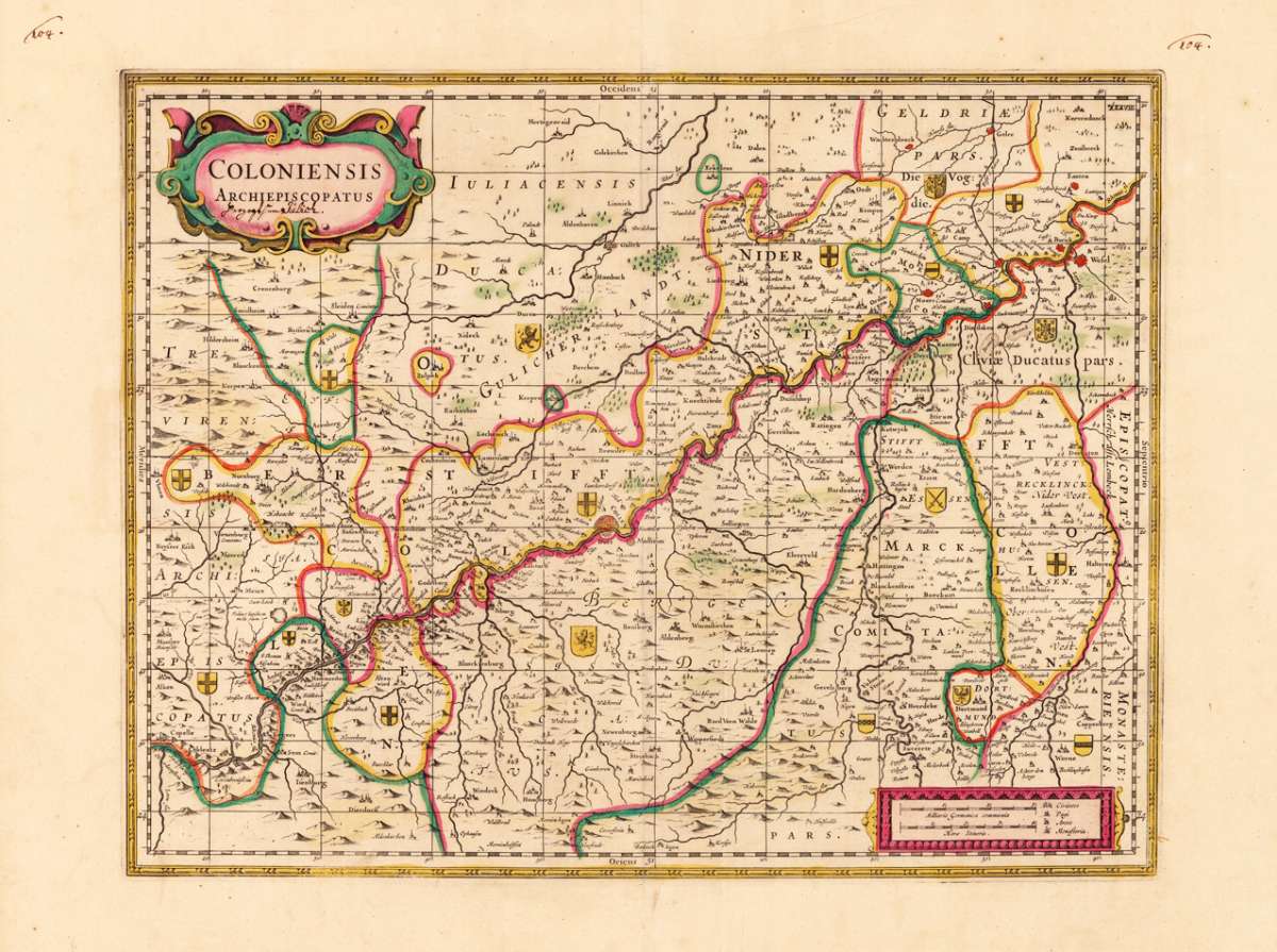
Coloniensis Archiepiscopatus
Coloniensis Archiepiscopatus - Joan. Jansonnius ∑ Hand-Colored Original Copperplate Engraving ∑ Amsterdam & Oxford 1680
Eigenschaften
- Published: Moses Pitt , Amsterdam & Oxford
- Published date: 1680
- Technique: Copper engraving / Original color.
- Type: Antique Map, map
- Issue date: 1680-83
- Category: Erzbistum Köln
- Size: 370 by 475mm (14 by 18 inches).
- Bibliography: Koeman I [2410:1.3]
- Stock number: 24653
- Condition: In very good to excellent condition with wide margins. On the sheet are some creases slightly visible. 370 by 475mm (14 by 18 inches).
Article description
Article description
Hand-Colored Original Copperplate Engraving by Joan. Jansonnius, depicting Coloniensis Archiepiscopatus. Published Amsterdam & Oxford, Moses Pitt, 1680. Sheet: 370 by 475mm (14 by 18 inches).. A fine and original hand-colored example of Jansonnius's celebrated cartographic work, documenting this region of Germany with the precision and decorative artistry characteristic of the 16800s. Johannes Janssonius (1588-1664) was one of the foremost Dutch cartographers and publishers of the 17th century, based in Amsterdam. A son-in-law of Jodocus Hondius, he continued the great Mercator-Hondius atlas tradition and was a fierce rival of Joan Blaeu. His multi-volume atlases -- published under the Mercator/Hondius/Janssonius imprint -- were standard reference works of the age, known for accurate engraving and fine hand coloring. Janssonius maps represent the very best of the Dutch Golden Age of cartography and are held in major collections worldwide. This original copperplate engraving, with original hand coloring depicts the region of Coloniensis Archiepiscopatus, published in Amsterdam & Oxford, Moses Pitt, 1680-83. The map features a decorative Baroque cartouche containing the title inscription. The map records the political and geographic boundaries of the region as understood in 1680-83, offering a fascinating window into the history of German territorial organization. Sheet measures 370 by 475mm (14 by 18 inches).. In good condition overall, with minor signs of age appropriate for a 17th-century engraving. Ready to frame.Coloniensis Archiepiscopatus - Joan. Jansonnius ∑ Hand-Colored Original Copperplate Engraving ∑ Amsterdam & Oxford 1680
Koeman I [2410:1.3]
You might also be interested in the following products
") Kleve (Herzogtum)
Kleve (Herzogtum) Hand-Colored Original Copperplate Engraving by Guijelmus Blaeu & Joan., depicting Kleve (Herzogtum). Published...
€380.00
 Köln
Köln Hand-Colored Original Copperplate Engraving by Matthäus Seutter, depicting Köln. Published Augsburg, 1730. Sheet: 503...
€380.00
 Paderborn
 Hand-Colored Original Copperplate Engraving by Matthäus Seutter, depicting Paderborn. Published Augsburg, Matthäus...
€675.00
 Clivia Ducatus et...
 Hand-Colored Original Copperplate Engraving by Guijelmus Blaeu & Joan., depicting Clivia Ducatus et Ravenstein...
€380.00
Recently viewed products