Homann, Johann Baptist
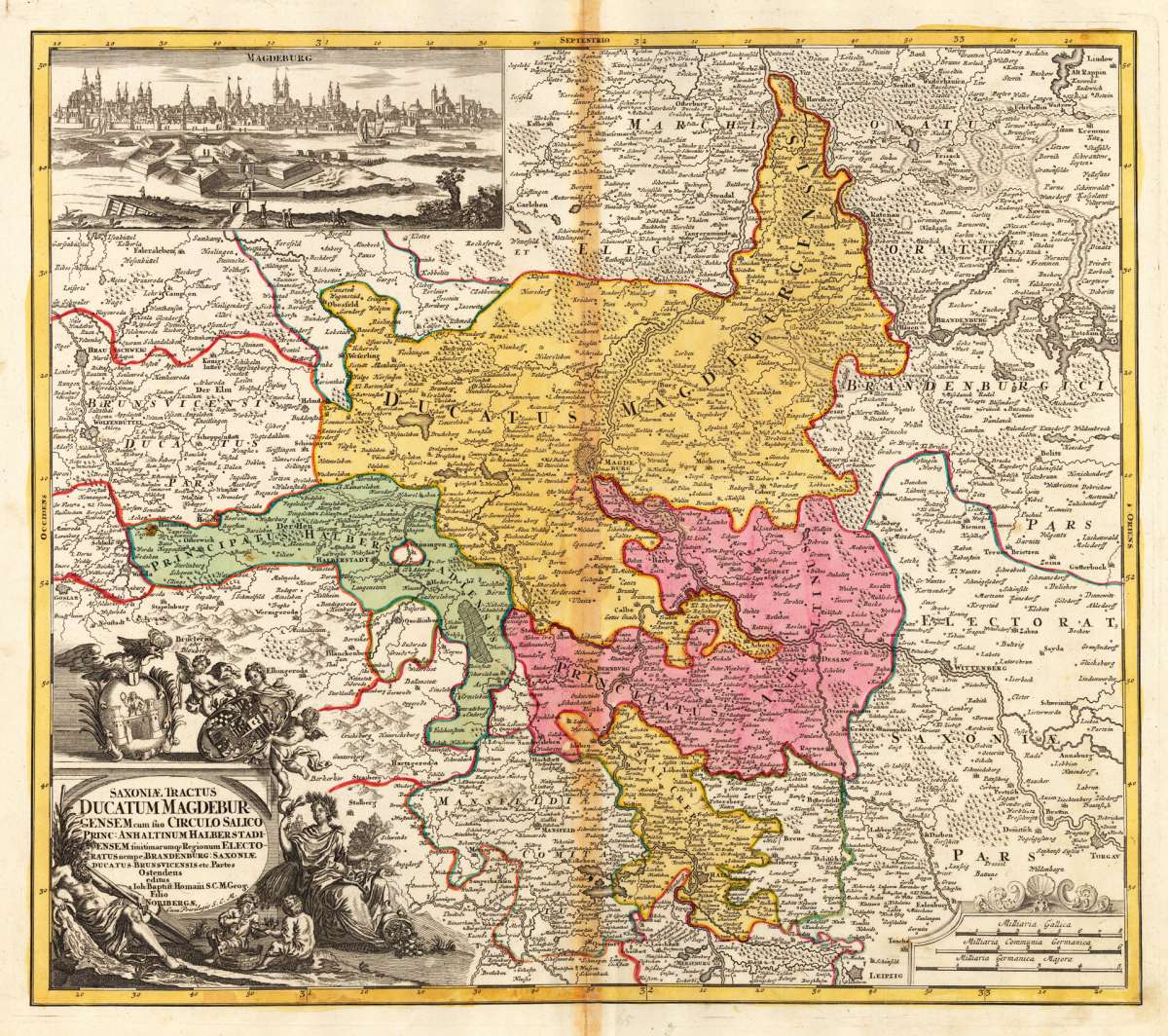
Saxoniae Tractus Ducatum Magdeburgcensem cum suo Circulo Salico Princ: Anhaltinum Halberstadiensem finitimarumq...
Saxoniae Tractus Ducatum Magdeburgcensem cum suo Circulo Salico Princ: Anhaltinum Halberstadiensem finitimarumq Regionum Electoratus nempe Brandenburg: Saxon...
Eigenschaften
- Published: Nürnberg; Homann; J. B.
- Published date: 1720
- Technique: Copper engraving / Original color.
- Type: Antique Map, map
- Issue date: 1720-40
- Category: Magdeburg
- Size: 473 by 538mm (18 by 21 inches).
- Stock number: 19863
- Condition: In very good condition. A minor old mending near the centre fold. 473 by 538mm (18 by 21 inches).
Article description
Article description
Hand-Colored Original Copperplate Engraving by Johann Baptist Homann, depicting Saxoniae Tractus Ducatum Magdeburgcensem cum suo Circulo Salico Princ: Anhaltinum Halberstadiensem finitimarumq Regionum Electoratus nempe Brandenburg: Saxoniae ducatus Brunsvicensis etc. Partes Ostendens editus a Ioh: Baptist: Homani S.C.M. Geog. Filio Noriberga,; cum Privilegio S.C.M.. Published Nürnberg; Homann; J. B., 1720. Sheet: 473 by 538mm (18 by 21 inches).. A fine and original hand-colored example of Homann's celebrated cartographic work, documenting this region of Germany with the precision and decorative artistry characteristic of the 17200s. Johann Baptist Homann (1664-1724) was the foremost map publisher of 18th-century Germany. Born in Bavaria, he founded his cartographic publishing house in Nuremberg in 1702 and within a decade had become the dominant force in German-language cartography. In 1715, Holy Roman Emperor Charles VI appointed him Imperial Cartographer -- a prestigious title that gave Homann access to the most current geographic data and exclusive publishing privileges. His maps are celebrated for their bold copper engraving, elaborate Baroque cartouches, and vivid original hand coloring. Following Homann's death in 1724, the firm continued under the imprint 'Homann Heirs' (Homannsche Erben). His maps are held in major collections worldwide, including the Library of Congress, the British Library, and the Bayerische Staatsbibliothek. This original copperplate engraving, with original hand coloring depicts the region of Saxoniae Tractus Ducatum Magdeburgcensem cum suo Circulo Salico Princ: Anhaltinum Halberstadiensem finitimarumq Regionum Electoratus nempe Brandenburg: Saxoniae ducatus Brunsvicensis etc. Partes Ostendens editus a Ioh: Baptist: Homani S.C.M. Geog. Filio Noriberga,; cum Privilegio S.C.M., published in Nürnberg; Homann; J. B., 1720-40. The map features a decorative Baroque cartouche containing the title inscription. A distance scale is incorporated within the cartouche or alongside it. The cartouche is elaborated with allegorical or figural ornamentation. The map records the political and geographic boundaries of the region as understood in 1720-40, offering a fascinating window into the history of German territorial organization. Sheet measures 473 by 538mm (18 by 21 inches).. In good condition overall, with minor signs of age appropriate for a 18th-century engraving. Ready to frame.Saxoniae Tractus Ducatum Magdeburgcensem cum suo Circulo Salico Princ: Anhaltinum Halberstadiensem finitimarumq Regionum Electoratus nempe Brandenburg: Saxon...
You might also be interested in the following products
 Saxoniae Tractus...
 Hand-Colored Original Copperplate Engraving by Johann Baptist Homann, depicting Saxoniae Tractus Ducatum...
€550.00
 Chorographia...
 Hand-Colored Original Copperplate Engraving by J.B. (Homann Heirs) Homann, depicting Chorographia Territorii...
€275.00
 Der Dom in Magdeburg
 Hand-Colored Original Copperplate Engraving by Gabriel Bodenehr, depicting Der Dom in Magdeburg. Published Augsburg,...
€95.00
 St. Peters Kirch...
 Hand-Colored Original Copperplate Engraving by Gabriel Bodenehr, depicting St. Peters Kirch in Magdeburg.. Published...
€95.00
Recently viewed products