Homann, Johann Baptist
Holstein
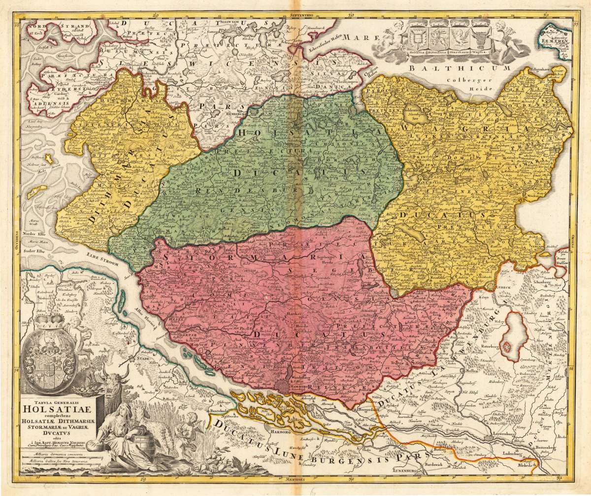
Holstein - Johann Baptist Homann ∑ Hand-Colored Original Copperplate Engraving ∑ Nürnberg 1720
Eigenschaften
- Published: Nürnberg
- Published date: 1720
- Technique: Copper engraving / Original color.
- Type: Antique Map, map
- Issue date: ca. 1720
- Category: Schleswig-Holstein
- Size: 482 by 576mm (19 by 22 inches).
- Stock number: 13598
- Condition: In excellent condition. 482 by 576mm (19 by 22 inches).
Article description
Article description
Hand-Colored Original Copperplate Engraving by Johann Baptist Homann, depicting Holstein. Published Nürnberg, 1720. Sheet: 482 by 576mm (19 by 22 inches).. A fine and original hand-colored example of Homann's celebrated cartographic work, documenting this region of Germany with the precision and decorative artistry characteristic of the 17200s. Johann Baptist Homann (1664-1724) was the foremost map publisher of 18th-century Germany. Born in Bavaria, he founded his cartographic publishing house in Nuremberg in 1702 and within a decade had become the dominant force in German-language cartography. In 1715, Holy Roman Emperor Charles VI appointed him Imperial Cartographer -- a prestigious title that gave Homann access to the most current geographic data and exclusive publishing privileges. His maps are celebrated for their bold copper engraving, elaborate Baroque cartouches, and vivid original hand coloring. Following Homann's death in 1724, the firm continued under the imprint 'Homann Heirs' (Homannsche Erben). His maps are held in major collections worldwide, including the Library of Congress, the British Library, and the Bayerische Staatsbibliothek. This original copperplate engraving, with original hand coloring depicts the region of Holstein, published in Nürnberg, ca. 1720. The map features a decorative Baroque cartouche containing the title inscription. A distance scale is incorporated within the cartouche or alongside it. Coats of arms of the relevant territories are displayed. The cartouche is elaborated with allegorical or figural ornamentation. The map records the political and geographic boundaries of the region as understood in ca. 1720, offering a fascinating window into the history of German territorial organization. Sheet measures 482 by 576mm (19 by 22 inches).. In good condition overall, with minor signs of age appropriate for a 18th-century engraving. Ready to frame.Holstein - Johann Baptist Homann ∑ Hand-Colored Original Copperplate Engraving ∑ Nürnberg 1720
You might also be interested in the following products
 Typus...
 Hand-Colored Original Copperplate Engraving by Johann Baptist Homann, depicting Typus Geographicus Ducat....
€445.00
 Pharus-Plan Kiel
 Hand-Colored Original Lithograph by Pharus Verlag, depicting Pharus-Plan Kiel. Published Pharus Verlag, Berlin, 1910....
€95.00
 Thietmarsiae,...
 Hand-Colored Original Copperplate Engraving by Abraham Ortelius, depicting Thietmarsiae, Holsaticae Regionis Partis...
€250.00
 Plan und Ansicht...
 Hand-Colored Original Steel Engraving by Joseph Meyer, depicting Plan und Ansicht von Helgoland. Published...
€120.00
Recently viewed products