Ortelius, Abraham
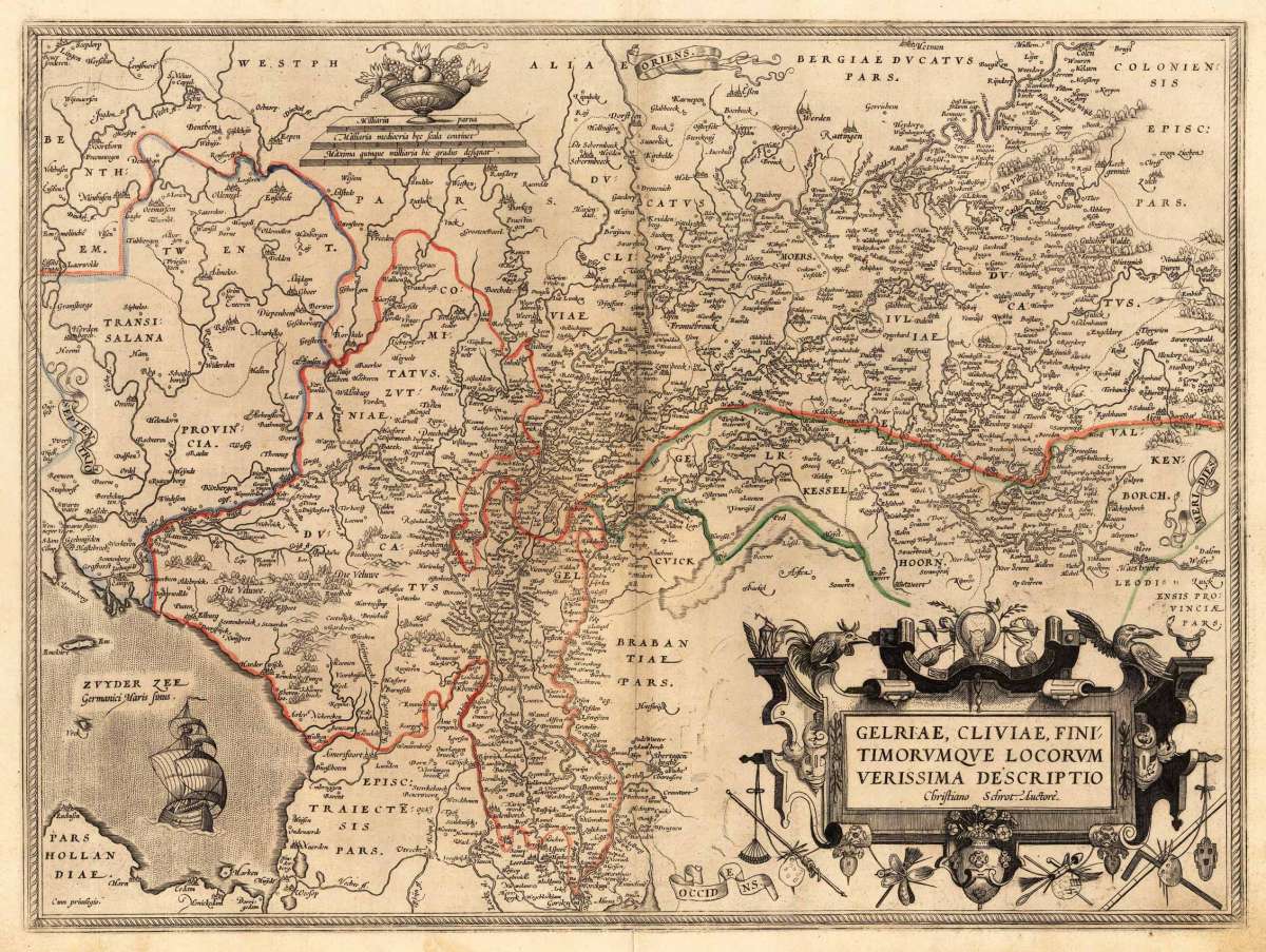
Gelriae, Cliviae, Finitiorumque Locorum Verissima Descriptio Christiano Schrot. Auctore
Eigenschaften
- Published: Antwerpen
- Published date: 1572
- Type: Antique Map, map
- Technique: Copperengraving/handcolored., Copper engraving / hand colored.
- Category: Netherlands
- Issue date: 1572 - 73
- Size: 370 by 500mm (14 by 19 inches).
- Bibliography: Koe. Ort 1C / 15. Broe. 61. 1 of 2.
- Stock number: 21923
- Condition: In very good to excellent condition. 370 by 500mm (14 by 19 inches).
Article description
Article description
Original antique copper engraving, hand colored in outline when published. Decorative map of Ortelius' first plate covering Gelderland. Based on Christiaan Sgrothen's map of 1567 and is richly engraved with fine detail particularly along the rivers. The map is oriented with north to the left with ribbon cartouches marking the cardinal directions. Two ships sail in the Zuyder Zee and a decorative cartouche with flowers and birds. Ortelius was born on 14 April 1527 in the city of Antwerp, which was then in the Habsburg Netherlands (modern-day Belgium). The Orthellius family were originally from Augsburg, a Free imperial city of the Holy Roman Empire. In 1535, the family had fallen under suspicion of Protestantism. Following the death of Ortelius's father, his uncle Jacobus van Meteren returned from religious exile in England to take care of Ortelius. Abraham remained close to his cousin Emanuel van Meteren, who would later move to London. In 1575 he was appointed geographer to the king of Spain, Philip II, on the recommendation of Arias Montanus, who vouched for his orthodoxy. He travelled extensively in Europe and is specifically known to have traveled throughout the Seventeen Provinces; in southern, western, northern, and eastern Germany (e.g., 1560, 1575–1576); France (1559–1560); England and Ireland (1576); and Italy (1578, and perhaps twice or thrice between 1550 and 1558). Beginning as a map-engraver, in 1547 he entered the Antwerp Guild of Saint Luke as an illuminator of maps. He supplemented his income trading in books, prints, and maps, and his journeys included yearly visits to the Frankfurt book and print fair, where he met Gerardus Mercator in 1554. In 1560, however, when travelling with Mercator to Trier, Lorraine, and Poitiers, he seems to have been attracted, largely by Mercator's influence, towards the career of a scientific geographer. (Wikipedia)Koe. Ort 1C / 15. Broe. 61. 1 of 2.
You might also be interested in the following products
 Tienen. - Tiena
 Copper engraving, uncolored as published in the townbook "Civitates Orbis Terrarum" by Georg Braun and...
€300.00
 Bergen op Zoom
 Original copper engraving, published ca. 1588 in volume III of the town book 'Civitates Orbis Terrarum' by...
€395.00
 Duynkercke. -...
 Original copper engraving, hand colored in wash, published 1578 in the townbook 'Civitates Orbis Terrarum' by Braun...
€395.00
 Gelriae, Cliviae,...
 Original antique copper engraving, published 1612 in a Italian text edition of the 'Theatrum Orbis...
€495.00
Recently viewed products