van Keulen, Gerard
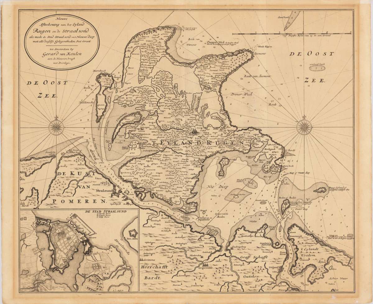
Nieuwe Afteekenin van het Eyland Rugen en de Straasond als mede de Stad Straalsond ent Nieuwe diep met alle desselfs...
€1,450.00
Prices incl. VAT plus shipping costs
This item is sold. Please contact us if you are searching for this item.
Eigenschaften
- Published: Amsterdam
- Published date: 1726
- Technique: Copper engraving
- Type: map
- Issue date: 1700-26
- Category: sea chart of Rügen & Usedom
- Size: 524 by 621mm (20 by 24 inches).
- Stock number: 30321
- Condition: In excellent condition.
Article description
Article description
Original antique copper engraving, uncolored as published. Published in ,de Nieuwen brugh' in Amsterdam. A very rare sea chart of the Baltic sea with the coastline from Bardt, Stralsund, Greifwalde and Wolgast in a large scale. The map features the island of Rügen and the neighbourging island Usedom. A highly detailled sea chart of this region in ,Mecklenburg-Vorpommern' with the coastling along the Baltic Sea. The map is in an extremly high scale with an enormous amount of small place names, islands, anchor places, marked sand banks, depths, etc. In the lower left corner eqipped with a fine plan of Stralsund. Johannes van Keulen (1654 in Deventer – 1715 in Amsterdam) was a 17th-century Dutch cartographer. He published the influential nautical atlas the Zee-Atlas and the pilot guide Zee-Fakkel (meaning Sea-Torch in English). In 1678 Johannes van Keulen established himself in Amsterdam and in 1680 he obtained a patent from the States of Holland and West Friesland allowing him to print and publish maritime atlases and shipping guides. These were books of maps and descriptions of itineraries, used by helmsmen for safe navigation. The patent was a kind of protection against illegal copying of produced books and charts. This was especially important for the atlases which were made with extensive initial costs. Van Keulen named his firm 'In de Gekroonde Lootsman' ('In the Crowned Pilot'). Soon Van Keulen struck a deal with cartographer Claes Jansz. Vooght. From 1681 onwards the Nieuwe Lichtende Zee-Fakkel appeared, a five-volume atlas for which Vooght compiled the maps[1] and which was illustrated by Jan Luyken. The five volume Zee-Fakkel made Johannes van Keulen famous. The Zee-Fakkel was published in 5 volumes between 1681 and 1684 containing over 130 new charts. (Wikipedia)You might also be interested in the following products
 Marchionatus...
 Copper-engraving, handcolored in wash and outline, when published. In the upper right corner ornated with a large...
€245.00
 Marchionatus...
 Copper-engraving, handcolored in wash and outline, when published. In the upper right corner ornated with a large...
€320.00
 Ducatus...
 Copperengraving, handcolored in outline when published. A decorative and accurate map of the duchy of Mecklenburg...
€350.00
 Ducatus...
 Copper engraving, hand colored in outline when published. A decorative and accurate map of the duchy of Mecklenburg...
€400.00
Recently viewed products