de Wit, Frederick
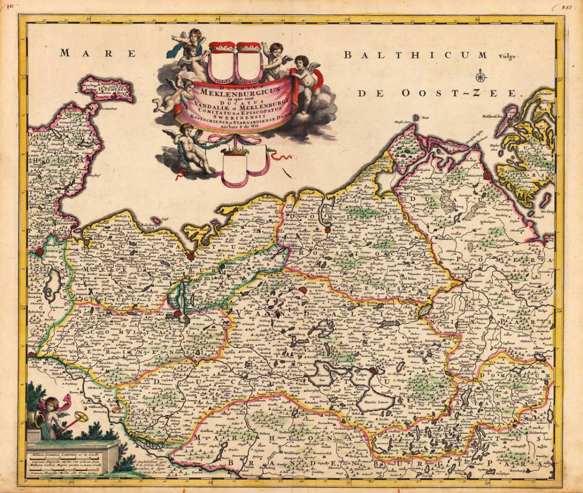
Ducatus Meklenburgicus in quo sunt Ducatus Vandaliae et Meklenburgi Comitatus et Episcopatus Swerinensis Rostochiense...
Ducatus Meklenburgicus in quo sunt Ducatus Vandaliae et Meklenburgi Comitatus et Episcopatus Swerinensis Rostochiense et Stargardiense Domin Auctore F de Wit...
Eigenschaften
- Published: de Wit , Amsterdam
- Published date: 1690
- Technique: Copper engraving / Original color.
- Type: Antique Map, map
- Category: Mecklenburg-Vorpommern
- Issue date: 1690-1700
- Size: 497 by 573mm (19 by 22 inches).
- Stock number: 17571
- Condition: In excellent condition. 497 by 573mm (19 by 22 inches).
Article description
Article description
Hand-Colored Original Copperplate Engraving by Frederick de Wit, depicting Ducatus Meklenburgicus in quo sunt Ducatus Vandaliae et Meklenburgi Comitatus et Episcopatus Swerinensis Rostochiense et Stargardiense Domin Auctore F de Wit. Published Amsterdam, de Wit, 1690. Sheet: 497 by 573mm (19 by 22 inches).. A fine and original hand-colored example of de Wit's celebrated cartographic work, documenting this region of Germany with the precision and decorative artistry characteristic of the 16900s. Frederick de Wit (c.1630-1706) was a Dutch cartographer and publisher based in Amsterdam, one of the most important map publishers of the later Dutch Golden Age. He produced a large number of maps and atlases from the 1660s onwards, many of which were later republished by Covens & Mortier and other Amsterdam publishers. His maps are known for their fine engraving quality and are considered among the best examples of late 17th-century Dutch cartography. This original copperplate engraving, with original hand coloring depicts the region of Ducatus Meklenburgicus in quo sunt Ducatus Vandaliae et Meklenburgi Comitatus et Episcopatus Swerinensis Rostochiense et Stargardiense Domin Auctore F de Wit, published in Amsterdam, de Wit, 1690-1700. The map features a decorative Baroque cartouche containing the title inscription. The map records the political and geographic boundaries of the region as understood in 1690-1700, offering a fascinating window into the history of German territorial organization. Sheet measures 497 by 573mm (19 by 22 inches).. In good condition overall, with minor signs of age appropriate for a 17th-century engraving. Ready to frame.Ducatus Meklenburgicus in quo sunt Ducatus Vandaliae et Meklenburgi Comitatus et Episcopatus Swerinensis Rostochiense et Stargardiense Domin Auctore F de Wit...
You might also be interested in the following products
 Marchionatus...
 Hand-Colored Original Etching by Matth us Seutter, depicting Marchionatus Brandenburgensis Ducatus Pomeraniae et...
€245.00
 Marchionatus...
 Hand-Colored Original Copperplate Engraving by Jean Covens & Cornelius Mortier, depicting Marchionatus...
€320.00
 Ducatus...
 Hand-Colored Original Copperplate Engraving by Rainer Ottens & Josua, depicting Ducatus Meklenburgicus in quo...
€350.00
 The N.E. Part of...
 Hand-Colored Original Copperplate Engraving by Herman Moll, depicting The N.E. Part of Germany Containing the...
€145.00
Recently viewed products