Seutter, Matth us
Marchionatus Brandenburgensis Ducatus Pomeraniae et Ducatus Mecklenburgicus excusi et venales prostantes apud...
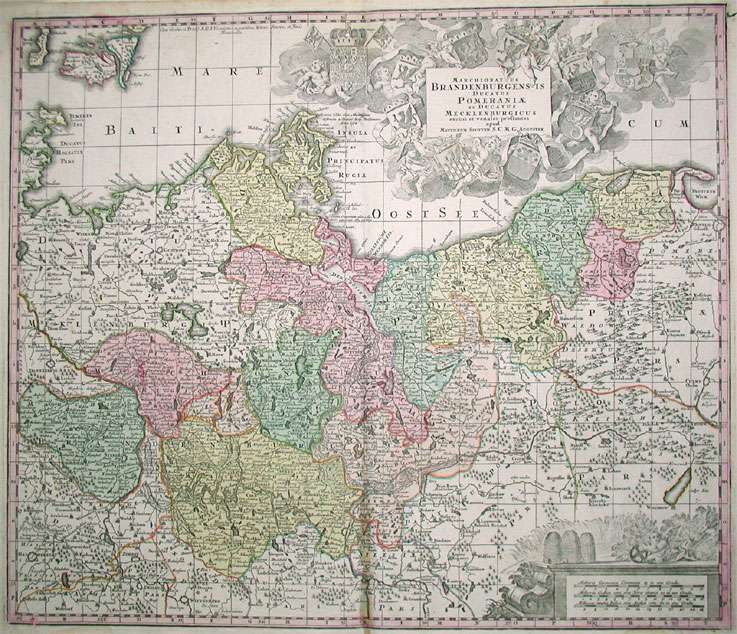
Marchionatus Brandenburgensis Ducatus Pomeraniae et Ducatus Mecklenburgicus excusi et venales prostantes apud Matthaeum Seutter, S.C.M.G. Augustan. - Matth u...
Eigenschaften
- Published: Augsburg
- Published date: 1720
- Technique: Copper engraving / Original color.
- Type: Antique Map, map
- Issue date: 1720/25
- Category: Brandenburg - Pommern
- Size: 500 by 585mm (19 by 23 inches).
- Stock number: 17036
- Condition: A very well preserved copy. The map in a good equal impression. In decorative body color, as published.
Article description
Article description
Hand-Colored Original Etching by Matth us Seutter, depicting Marchionatus Brandenburgensis Ducatus Pomeraniae et Ducatus Mecklenburgicus excusi et venales prostantes apud Matthaeum Seutter, S.C.M.G. Augustan.. Published Augsburg, 1720. Sheet: 500 by 585mm (19 by 23 inches).. A fine and original hand-colored example of Seutter's celebrated cartographic work, documenting this region of Germany with the precision and decorative artistry characteristic of the 17200s. Matthaus Seutter (1678-1757) was one of the most prolific German cartographers of the 18th century, based in Augsburg. He trained as an engraver under Johann Baptist Homann in Nuremberg before establishing his own publishing firm in Augsburg around 1717. His skill and output were so impressive that Holy Roman Emperor Charles VI appointed him Imperial Geographer in 1732 -- a title he shared with his former master Homann. Seutter produced over 500 maps during his career, known for their richly detailed cartouches, decorative borders, and brilliant hand coloring. His work is held in collections at the Augsburg City Library, the Staatsbibliothek Berlin, and major museums across Europe. This original etching, with original hand coloring depicts the region of Marchionatus Brandenburgensis Ducatus Pomeraniae et Ducatus Mecklenburgicus excusi et venales prostantes apud Matthaeum Seutter, S.C.M.G. Augustan., published in Augsburg, 1720/25. The map features a decorative Baroque cartouche containing the title inscription. A distance scale is incorporated within the cartouche or alongside it. The cartouche is elaborated with allegorical or figural ornamentation. The map records the political and geographic boundaries of the region as understood in 1720/25, offering a fascinating window into the history of German territorial organization. Sheet measures 500 by 585mm (19 by 23 inches).. In good condition overall, with minor signs of age appropriate for a 18th-century engraving. Ready to frame.Marchionatus Brandenburgensis Ducatus Pomeraniae et Ducatus Mecklenburgicus excusi et venales prostantes apud Matthaeum Seutter, S.C.M.G. Augustan. - Matth u...
You might also be interested in the following products
 Marchionatus...
 Hand-Colored Original Copperplate Engraving by Jean Covens & Cornelius Mortier, depicting Marchionatus...
€320.00
 Ducatus...
 Hand-Colored Original Copperplate Engraving by Rainer Ottens & Josua, depicting Ducatus Meklenburgicus in quo...
€350.00
 Ducatus...
 Hand-Colored Original Copperplate Engraving by Frederick de Wit, depicting Ducatus Meklenburgicus in quo sunt Ducatus...
€400.00
 The N.E. Part of...
 Hand-Colored Original Copperplate Engraving by Herman Moll, depicting The N.E. Part of Germany Containing the...
€145.00
Recently viewed products