Homann, J.B. (Homann Heirs)
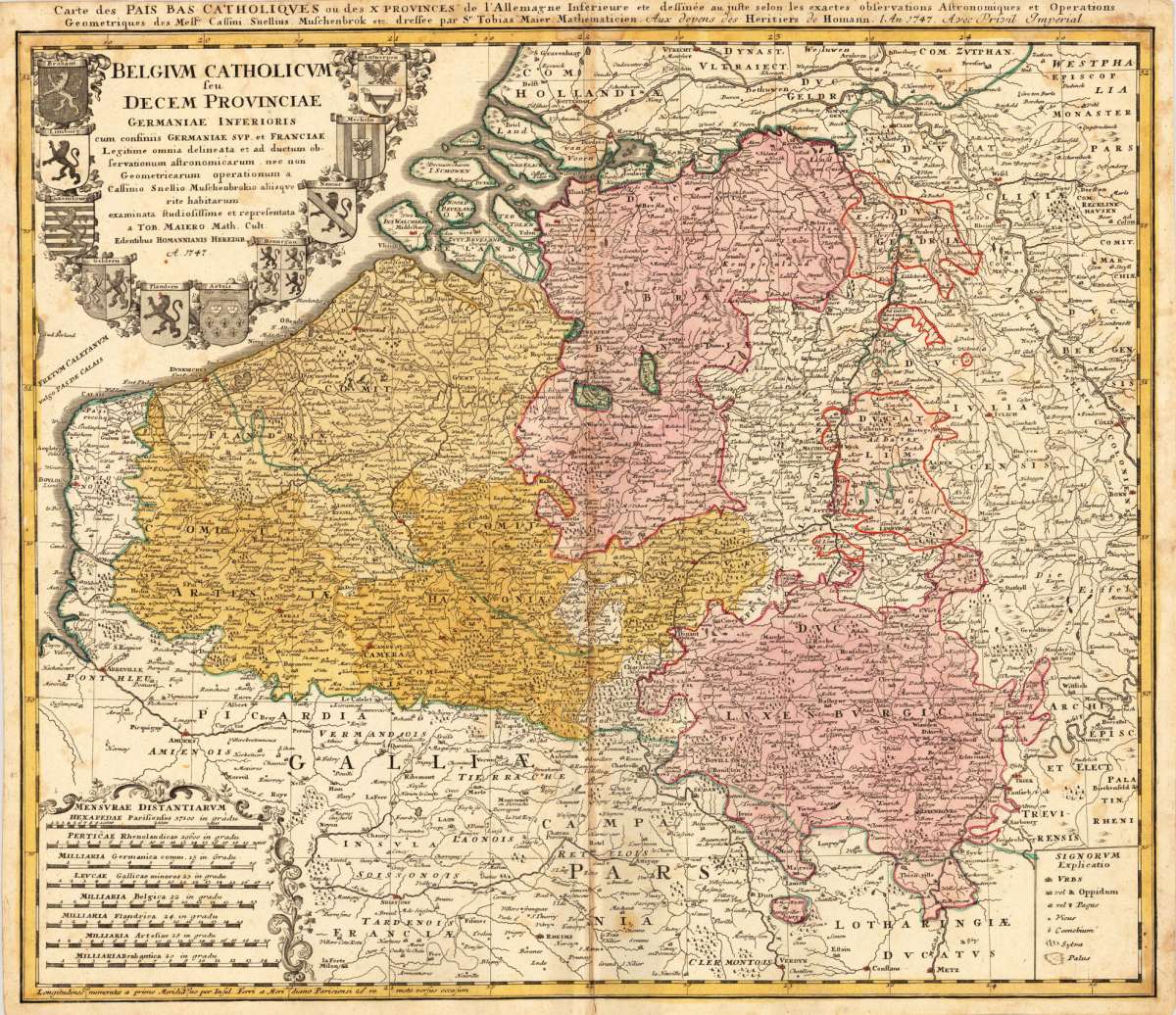
Belgium Catholicum seu Decem Provinciae Germaniae Inferioris cum consiniis Germaniae Sup. et Franciae Legitime omnia...
Carte des Pais Bas Catholiques ou des X Provinces de l'Allemagne Inserieure etc dessinée au juste selon les exactes observations Astronomiques et Operations Geometriques des Messur. Cassini. Snellius. Muschenbrok etc. dressee par Sr. Tobias Maier Mathematicien. Aux depens des Heritiers de Homann. 1 An 1747. Avec Privil Imperial
Eigenschaften
- Published: Nürnberg
- Published date: 1747
- Technique: Copper engraving / Original color.
- Type: Antique Map, map
- Category: Belgium
- Issue date: 1747
- Size: 474 by 556mm (18 by 22 inches).
- Stock number: 20669
- Condition: In good condition. Cut close to the descriptive text at the top of the map. A small mending at the bottom of the centre fold, a few minor spots, mostly only visible verso. 474 by 556mm (18 by 22 inches).
Article description
Article description
Original antique copper engraving, hand colored in outline and wash when published. This antique map shows Belgium with its neighboring counties Luxembourg and Holland. The map is equipped with many place names, rivers, woods, lakes, etc. Around the title, which is in the upper left corner, are many coat of arms. In the lower left corner we see an allegoric cartouche, which has the mileage scale inside. The explanation from the map is in the lower right corner. Johann Baptist Homann (20 March 1664 – 1 July 1724) was a German geographer and cartographer, who also made maps of the Americas. Homann was born in Oberkammlach near Kammlach in the Electorate of Bavaria. Although educated at a Jesuit school, and preparing for an ecclesiastical career, he eventually converted to Protestantism and from 1687 worked as a civil law notary in Nuremberg. He soon turned to engraving and cartography; in 1702 he founded his own publishing house. Homann acquired renown as a leading German cartographer, and in 1715 was appointed Imperial Geographer by Emperor Charles VI. Giving such privileges to individuals was an added right that the Holy Roman Emperor enjoyed. In the same year he was also named a member of the Prussian Academy of Sciences in Berlin. Of particular significance to cartography were the imperial printing privileges (Latin: privilegia impressoria). These protected for a time the authors in all scientific fields such as printers, copper engravers, map makers and publishers. They were also very important as a recommendation for potential customers. In 1716 Homann published his masterpiece Grosser Atlas ueber die ganze Welt (Grand Atlas of all the World). Numerous maps were drawn up in cooperation with the engraver Christoph Weigel the Elder, who also published Siebmachers Wappenbuch. Homann died in Nuremberg in 1724. He was succeeded by his son Johann Christoph (1703-1730). The company carried on upon his death as Homann heirs company, managed by Johann Michael Franz and Johann Georg Ebersberger. After subsequent changes in management the company folded in 1852.[1] The company was known as "Homann Erben", "Homanniani Heredes", or "Heritiers de Homann" abroad. (Wikipedia)Carte des Pais Bas Catholiques ou des X Provinces de l'Allemagne Inserieure etc dessinée au juste selon les exactes observations Astronomiques et Operations Geometriques des Messur. Cassini. Snellius. Muschenbrok etc. dressee par Sr. Tobias Maier Mathematicien. Aux depens des Heritiers de Homann. 1 An 1747. Avec Privil Imperial
You might also be interested in the following products
 Nobilis Hannoniae...
 Original copper engraving, published 1588 in the first Spanish text edition of the 'Theatrum Orbis...
€295.00
 Leodiensis...
 Original antique copper engraving, published 1598 in a French text edition of the 'Theatrum Orbis...
€495.00
 Accurata...
 Copper-engraving, handcolored in outline and wash when published. With many engraved place names of smaller cities...
€190.00
 Brabantiae...
 Copper-engraving, handcolored in wsh and outline when published. Detailed map of the duchy of Brabant with the...
€260.00
Recently viewed products