Homann, Baptist
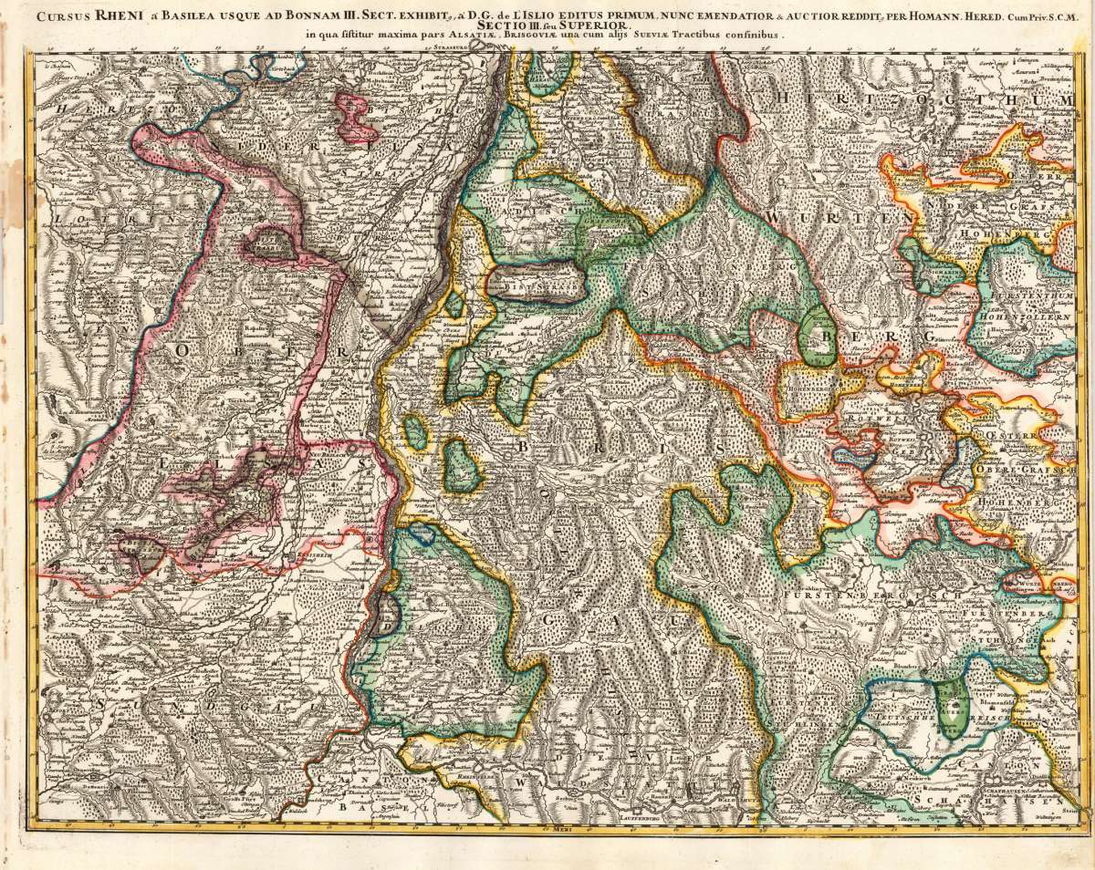
Cursus Rheni á Basilea usque ad Bonnam III. Sect. Exhibit, a D.G. de L'Islio Editus Primum, Nunc Emendatior & Auctior...
Cursus Rheni á Basilea usque ad Bonnam III. Sect. Exhibit, a D.G. de L'Islio Editus Primum, Nunc Emendatior & Auctior Reddit, per Homann. Hered. Cum Priv. S....
Eigenschaften
- Published: Homann , Nürnberg
- Published date: 1720
- Type: Antique Map, map
- Technique: Copper engraving / later handcolor
- Issue date: 1720
- Category: River Rhine & Black Forest
- Size: 470 by 607mm (18 by 24 inches).
- Stock number: 20492
- Condition: Published plano without a centre fold. In excellent condition. A strong and clear impression. 470 by 607mm (18 by 24 inches).
Article description
Article description
Hand-Colored Original Copperplate Engraving by Baptist Homann, depicting Cursus Rheni á Basilea usque ad Bonnam III. Sect. Exhibit, a D.G. de L'Islio Editus Primum, Nunc Emendatior & Auctior Reddit, per Homann. Hered. Cum Priv. S.C.M. in qua sistitur maxima pars Alsatiae, Brisgoviae una cum alijs Sueviae Tractibus consinibus.. Published Nürnberg, Homann, 1720. Sheet: 470 by 607mm (18 by 24 inches).. A fine and original hand-colored example of Homann's celebrated cartographic work, documenting this region of Germany with the precision and decorative artistry characteristic of the 17200s. Johann Baptist Homann (1664-1724) was the foremost map publisher of 18th-century Germany. Born in Bavaria, he founded his cartographic publishing house in Nuremberg in 1702 and within a decade had become the dominant force in German-language cartography. In 1715, Holy Roman Emperor Charles VI appointed him Imperial Cartographer -- a prestigious title that gave Homann access to the most current geographic data and exclusive publishing privileges. His maps are celebrated for their bold copper engraving, elaborate Baroque cartouches, and vivid original hand coloring. Following Homann's death in 1724, the firm continued under the imprint 'Homann Heirs' (Homannsche Erben). His maps are held in major collections worldwide, including the Library of Congress, the British Library, and the Bayerische Staatsbibliothek. This original copperplate engraving, with original hand coloring depicts the region of Cursus Rheni á Basilea usque ad Bonnam III. Sect. Exhibit, a D.G. de L'Islio Editus Primum, Nunc Emendatior & Auctior Reddit, per Homann. Hered. Cum Priv. S.C.M. in qua sistitur maxima pars Alsatiae, Brisgoviae una cum alijs Sueviae Tractibus consinibus., published in Nürnberg, Homann, 1720. A distance scale is incorporated within the cartouche or alongside it. The map records the political and geographic boundaries of the region as understood in 1720, offering a fascinating window into the history of German territorial organization. Sheet measures 470 by 607mm (18 by 24 inches).. In good condition overall, with minor signs of age appropriate for a 18th-century engraving. Ready to frame.Cursus Rheni á Basilea usque ad Bonnam III. Sect. Exhibit, a D.G. de L'Islio Editus Primum, Nunc Emendatior & Auctior Reddit, per Homann. Hered. Cum Priv. S....
You might also be interested in the following products
 Württemberg...
 Hand-Colored Original Copperplate Engraving by Petrus Schenk & Gerard Valck, depicting Württemberg Herzogtum....
€450.00
 Circuli Sueviae...
 Hand-Colored Original Copperplate Engraving by Johann Baptist Homann, depicting Circuli Sueviae Mappa ex subsidiis...
€345.00
 Pharus-Plan...
 Original Lithograph by Pharus Verlag, depicting Pharus-Plan Stuttgart. Published Pharus Verlag, Berlin, 1910. Sheet:...
€95.00
 Circulus Suevicus...
 Hand-Colored Original Copperplate Engraving by Matthäus Seutter, depicting Circulus Suevicus in quo Ducatus...
€450.00
Recently viewed products