Jansonnius, Joan.
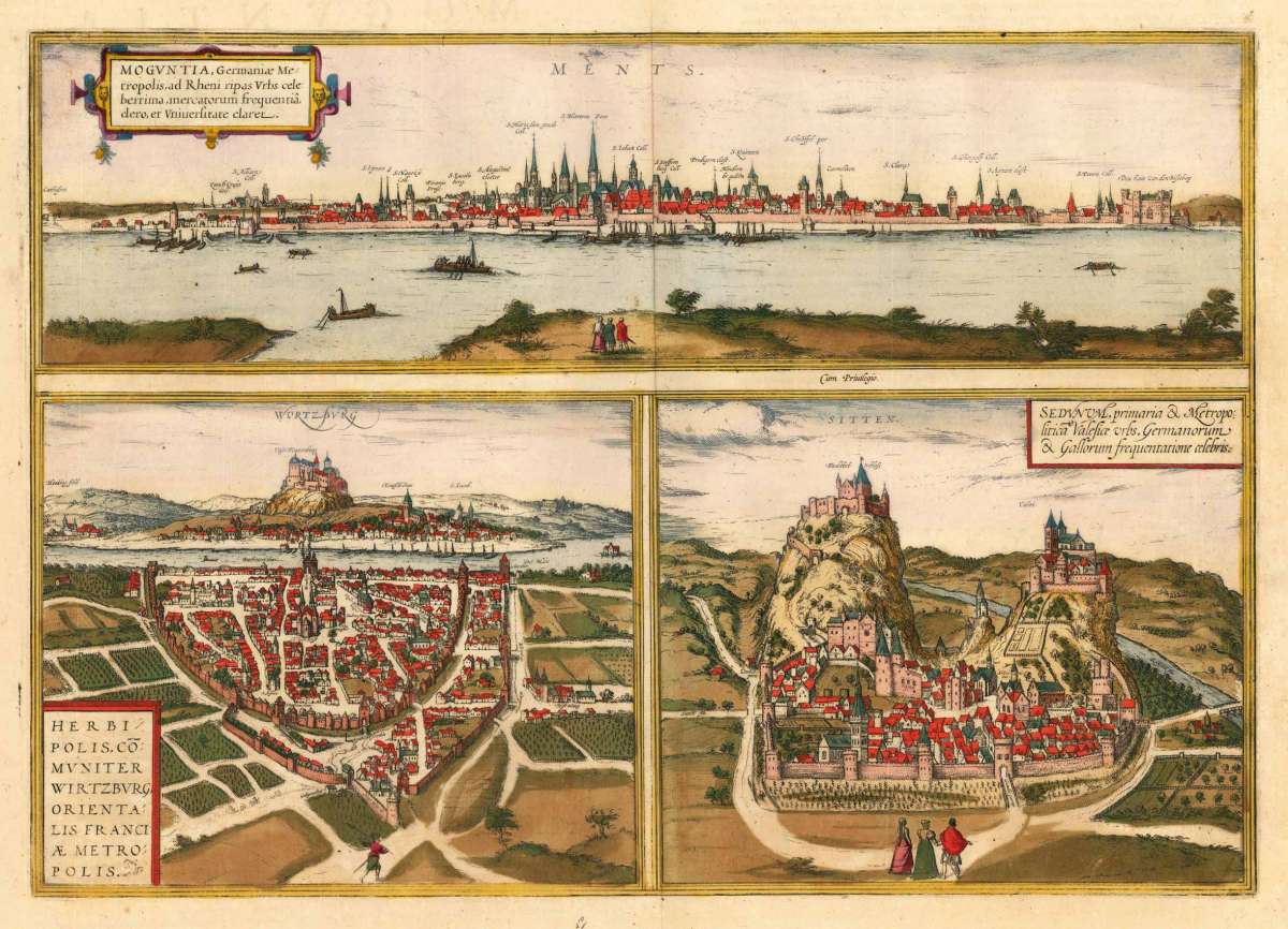
Moguntia, Germaniae Metropolis, ad Rheni ripas Urbs deleberrima, mercatorum frequenria, clero, er Universitate claret...
Moguntia, Germaniae Metropolis, ad Rheni ripas Urbs deleberrima, mercatorum frequenria, clero, er Universitate claret - Herbipolis, comuniter Wirtzburg, orie...
Eigenschaften
- Published: Joan. Janssonius , Amsterdam
- Published date: 1657
- Type: Antique Map, map
- Technique: Copper engraving / Original color
- Issue date: 1657
- Category: Mainz, Würzburg und Sitten
- Size: 337 by 478mm (13 by 18 inches).
- Stock number: 28183
- Condition: In excellent condition. 337 by 478mm (13 by 18 inches).
Article description
Article description
Hand-Colored Original Copperplate Engraving by Joan. Jansonnius, depicting Moguntia, Germaniae Metropolis, ad Rheni ripas Urbs deleberrima, mercatorum frequenria, clero, er Universitate claret - Herbipolis, comuniter Wirtzburg, orientalis Franciae Metropolis - Sedunum, primaria & Metropolitica Valesice urbs, Germanorum & Gallorum frequentatione celebris.. Published Amsterdam, Joan. Janssonius, 1657. Sheet: 337 by 478mm (13 by 18 inches).. A fine and original hand-colored example of Jansonnius's celebrated cartographic work, documenting this region of Germany with the precision and decorative artistry characteristic of the 16500s. Johannes Janssonius (1588-1664) was one of the foremost Dutch cartographers and publishers of the 17th century, based in Amsterdam. A son-in-law of Jodocus Hondius, he continued the great Mercator-Hondius atlas tradition and was a fierce rival of Joan Blaeu. His multi-volume atlases -- published under the Mercator/Hondius/Janssonius imprint -- were standard reference works of the age, known for accurate engraving and fine hand coloring. Janssonius maps represent the very best of the Dutch Golden Age of cartography and are held in major collections worldwide. This original copperplate engraving, with original hand coloring depicts the region of Moguntia, Germaniae Metropolis, ad Rheni ripas Urbs deleberrima, mercatorum frequenria, clero, er Universitate claret - Herbipolis, comuniter Wirtzburg, orientalis Franciae Metropolis - Sedunum, primaria & Metropolitica Valesice urbs, Germanorum & Gallorum frequentatione celebris., published in Amsterdam, Joan. Janssonius, 1657. The map records the political and geographic boundaries of the region as understood in 1657, offering a fascinating window into the history of German territorial organization. Sheet measures 337 by 478mm (13 by 18 inches).. In good condition overall, with minor signs of age appropriate for a 17th-century engraving. Ready to frame.Moguntia, Germaniae Metropolis, ad Rheni ripas Urbs deleberrima, mercatorum frequenria, clero, er Universitate claret - Herbipolis, comuniter Wirtzburg, orie...
You might also be interested in the following products
 Mindelheim.
 Hand-Colored Original Copperplate Engraving by Johann Baptist Homann, depicting Mindelheim.. Published Nürnberg,...
€475.00
 Augspurg mit...
 Hand-Colored Original Copperplate Engraving by Christoph Weigel, depicting Augspurg mit umliegender Gegend und dabey...
€195.00
 Circulus...
 Hand-Colored Original Copperplate Engraving by Christoph Weigel, depicting Circulus Franconicus ad Occidentem vergens...
€195.00
 Oberbayern
 Hand-Colored Original Copperplate Engraving by Johann Baptist Homann, depicting Oberbayern. Published Nürnberg,...
€295.00
Recently viewed products