Seutter, Matthäus
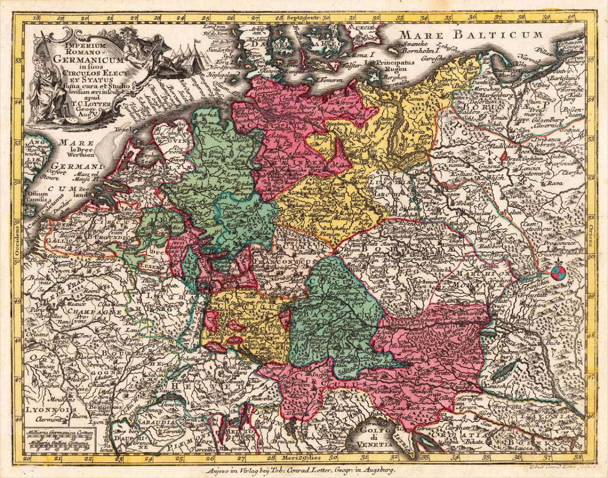
Imperium Romano- Germanicum insuos Circulos Elect Et Status suma cura et Studio divisum aeri insculpt apud T.C....
Imperium Romano- Germanicum insuos Circulos Elect Et Status suma cura et Studio divisum aeri insculpt apud T.C. Lotter Geogr. Aug. V. - Matthäus Seutter ∑ Ha...
Eigenschaften
- Published: G. C. Lotter , Augsburg
- Published date: 1756
- Technique: Copper engraving / Original color.
- Type: Antique Map, map
- Issue date: 1756-60
- Category: Roman Germany
- Size: 196 by 255mm (7 by 10 inches).
- Stock number: 24775
- Condition: In excellent condition. 196 by 255mm (7 by 10 inches).
Article description
Article description
Hand-Colored Original Copperplate Engraving by Matthäus Seutter, depicting Imperium Romano- Germanicum insuos Circulos Elect Et Status suma cura et Studio divisum aeri insculpt apud T.C. Lotter Geogr. Aug. V.. Published Augsburg, G. C. Lotter, 1756. Sheet: 196 by 255mm (7 by 10 inches).. A fine and original hand-colored example of Seutter's celebrated cartographic work, documenting this region of Germany with the precision and decorative artistry characteristic of the 17500s. Matthaus Seutter (1678-1757) was one of the most prolific German cartographers of the 18th century, based in Augsburg. He trained as an engraver under Johann Baptist Homann in Nuremberg before establishing his own publishing firm in Augsburg around 1717. His skill and output were so impressive that Holy Roman Emperor Charles VI appointed him Imperial Geographer in 1732 -- a title he shared with his former master Homann. Seutter produced over 500 maps during his career, known for their richly detailed cartouches, decorative borders, and brilliant hand coloring. His work is held in collections at the Augsburg City Library, the Staatsbibliothek Berlin, and major museums across Europe. This original copperplate engraving, with original hand coloring depicts the region of Imperium Romano- Germanicum insuos Circulos Elect Et Status suma cura et Studio divisum aeri insculpt apud T.C. Lotter Geogr. Aug. V., published in Augsburg, G. C. Lotter, 1756-60. The map records the political and geographic boundaries of the region as understood in 1756-60, offering a fascinating window into the history of German territorial organization. Sheet measures 196 by 255mm (7 by 10 inches).. In good condition overall, with minor signs of age appropriate for a 18th-century engraving. Ready to frame.Imperium Romano- Germanicum insuos Circulos Elect Et Status suma cura et Studio divisum aeri insculpt apud T.C. Lotter Geogr. Aug. V. - Matthäus Seutter ∑ Ha...
You might also be interested in the following products
 Trier - Koblentz...
 Hand-Colored Original Copperplate Engraving by Georg Braun & Franz Hogenberg, depicting Trier - Koblentz -...
€595.00
 Neus
Neus Hand-Colored Original Copperplate Engraving by Georg Braun & Franz Hogenberg, depicting Neus. Published Cologne,...
€745.00
 Campidonia vulgo...
 Hand-Colored Original Copperplate Engraving by Georg Braun & Franz Hogenberg, depicting Campidonia vulgo...
€850.00
 Novesium vulgo...
 Hand-Colored Original Copperplate Engraving by Georg Braun & Franz Hogenberg, depicting Novesium vulgo Neus; urbs...
€800.00
Recently viewed products