Hubert, Jaillot
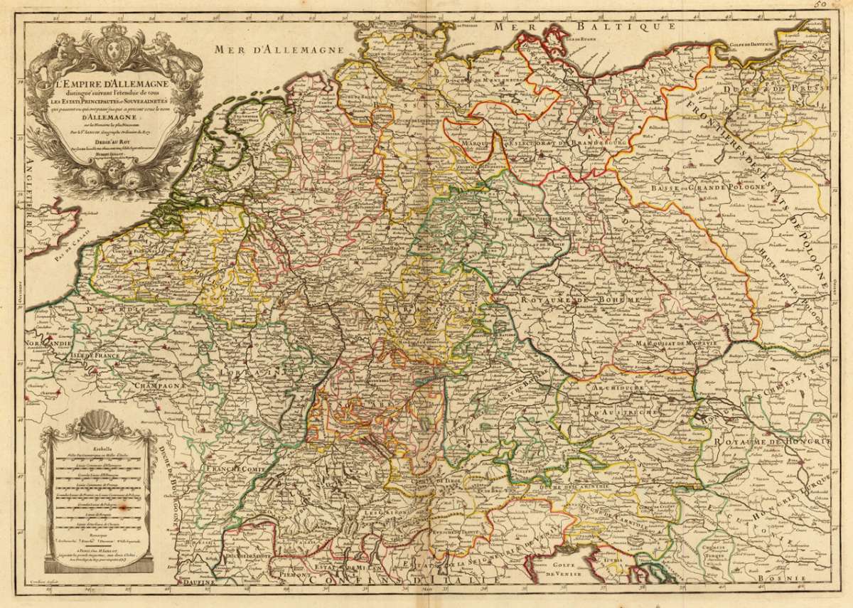
L´Empire D´Allemagne distingué siuvant l´étendue de tous Les Estats Principautés et Souverainetés qui passent ou qui...
L´Empire D´Allemagne distingué siuvant l´étendue de tous Les Estats Principautés et Souverainetés qui passent ou qui ont passé jusque sous le nom D' Allemagn...
Eigenschaften
- Published: Hubert Iaillot , Paris
- Published date: 1713
- Type: Antique Map, map
- Issue date: 1713
- Technique: Copper engraving / Original color
- Category: German empire
- Size: 45.8 by 65,0mm (1 by 2 inches).
- Stock number: 29604
- Condition: In excellent condition.
Article description
Article description
Hand-Colored Original Copperplate Engraving by Jaillot Hubert, depicting L´Empire D´Allemagne distingué siuvant l´étendue de tous Les Estats Principautés et Souverainetés qui passent ou qui ont passé jusque sous le nom D' Allemagne sur lkes Memoires les plus Nouveaux Par le Sr. Sanson, Geographe Ordinaire du Roy. Dedie´au Roy Parson tres humble, tres obeissant, tres fidele Sujet et Serviteur. Hubert Iaillot Geographe ordinaire de Sa Majesté. Published Paris, Hubert Iaillot, 1713. Sheet: 45.8 by 65,0mm (1 by 2 inches).. A fine and original hand-colored example of Hubert's celebrated cartographic work, documenting this region of Germany with the precision and decorative artistry characteristic of the 17100s. Alexis-Hubert Jaillot (c.1632-1712) was one of the foremost French cartographers of the late 17th and early 18th centuries. Working in Paris, he produced magnificent large-format maps of European territories, often in collaboration with Nicolas Sanson -- considered the father of French cartography. Jaillot's maps are known for their striking decorative cartouches, generous size, and fine hand coloring, representing the pinnacle of French Baroque cartography. This original copperplate engraving, with original hand coloring depicts the region of L´Empire D´Allemagne distingué siuvant l´étendue de tous Les Estats Principautés et Souverainetés qui passent ou qui ont passé jusque sous le nom D' Allemagne sur lkes Memoires les plus Nouveaux Par le Sr. Sanson, Geographe Ordinaire du Roy. Dedie´au Roy Parson tres humble, tres obeissant, tres fidele Sujet et Serviteur. Hubert Iaillot Geographe ordinaire de Sa Majesté, published in Paris, Hubert Iaillot, 1713. The map features a decorative Baroque cartouche containing the title inscription. A distance scale is incorporated within the cartouche or alongside it. The cartouche is elaborated with allegorical or figural ornamentation. The map records the political and geographic boundaries of the region as understood in 1713, offering a fascinating window into the history of German territorial organization. Sheet measures 45.8 by 65,0mm (1 by 2 inches).. In good condition overall, with minor signs of age appropriate for a 18th-century engraving. Ready to frame.L´Empire D´Allemagne distingué siuvant l´étendue de tous Les Estats Principautés et Souverainetés qui passent ou qui ont passé jusque sous le nom D' Allemagn...
You might also be interested in the following products
 Trier - Koblentz...
 Hand-Colored Original Copperplate Engraving by Georg Braun & Franz Hogenberg, depicting Trier - Koblentz -...
€595.00
 Neus
Neus Hand-Colored Original Copperplate Engraving by Georg Braun & Franz Hogenberg, depicting Neus. Published Cologne,...
€745.00
 Campidonia vulgo...
 Hand-Colored Original Copperplate Engraving by Georg Braun & Franz Hogenberg, depicting Campidonia vulgo...
€850.00
 Novesium vulgo...
 Hand-Colored Original Copperplate Engraving by Georg Braun & Franz Hogenberg, depicting Novesium vulgo Neus; urbs...
€800.00
Recently viewed products