de Wit, Frederic
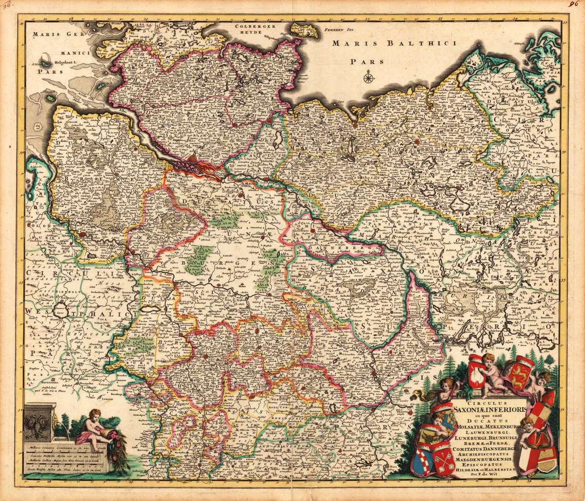
Circulus Saxoniae, Inferioris in quo sunt Ducatus Holsatiae, Meklenburgi, Lauwendurgi, Luneburgi, Brunsuigi, Bremae...
Circulus Saxoniae, Inferioris in quo sunt Ducatus Holsatiae, Meklenburgi, Lauwendurgi, Luneburgi, Brunsuigi, Bremae et Ferdae, Comitatus Dannebergi, Archiepi...
Eigenschaften
- Published: de Wit , Amsterdam
- Published date: 1680
- Technique: Copper engraving / Original color.
- Type: Antique Map, map
- Issue date: 1680
- Category: Niedersachsen
- Size: 495 by 575mm (19 by 22 inches).
- Stock number: 17370
- Condition: Near the centerfold one is crease slightly visible else in excellent condition. 495 by 575mm (19 by 22 inches).
Article description
Article description
Hand-Colored Original Copperplate Engraving by Frederic de Wit, depicting Circulus Saxoniae, Inferioris in quo sunt Ducatus Holsatiae, Meklenburgi, Lauwendurgi, Luneburgi, Brunsuigi, Bremae et Ferdae, Comitatus Dannebergi, Archiepiscopatus Maegdenburgensis, Episcopatus Hildesiae et Halberstad Per F. de Wit.. Published Amsterdam, de Wit, 1680. Sheet: 495 by 575mm (19 by 22 inches).. A fine and original hand-colored example of de Wit's celebrated cartographic work, documenting this region of Germany with the precision and decorative artistry characteristic of the 16800s. Frederick de Wit (c.1630-1706) was a Dutch cartographer and publisher based in Amsterdam, one of the most important map publishers of the later Dutch Golden Age. He produced a large number of maps and atlases from the 1660s onwards, many of which were later republished by Covens & Mortier and other Amsterdam publishers. His maps are known for their fine engraving quality and are considered among the best examples of late 17th-century Dutch cartography. This original copperplate engraving, with original hand coloring depicts the region of Circulus Saxoniae, Inferioris in quo sunt Ducatus Holsatiae, Meklenburgi, Lauwendurgi, Luneburgi, Brunsuigi, Bremae et Ferdae, Comitatus Dannebergi, Archiepiscopatus Maegdenburgensis, Episcopatus Hildesiae et Halberstad Per F. de Wit., published in Amsterdam, de Wit, 1680. The map features a decorative Baroque cartouche containing the title inscription. A distance scale is incorporated within the cartouche or alongside it. The cartouche is elaborated with allegorical or figural ornamentation. The map records the political and geographic boundaries of the region as understood in 1680, offering a fascinating window into the history of German territorial organization. Sheet measures 495 by 575mm (19 by 22 inches).. In good condition overall, with minor signs of age appropriate for a 17th-century engraving. Ready to frame.Circulus Saxoniae, Inferioris in quo sunt Ducatus Holsatiae, Meklenburgi, Lauwendurgi, Luneburgi, Brunsuigi, Bremae et Ferdae, Comitatus Dannebergi, Archiepi...
You might also be interested in the following products
 Niedersachsen
 Hand-Colored Original Copperplate Engraving by Gerard Mercator, depicting Niedersachsen. Published Amsterdam, Jodocus...
€300.00
 Episcopatuum...
 Hand-Colored Original Copperplate Engraving by Matthäus Seutter, depicting Episcopatuum Monasteriensis Et...
€495.00
 Saxoniae...
 Hand-Colored Original Copperplate Engraving by Matthäus Seutter, depicting Saxoniae Inferioris Circulus juxta...
€300.00
 Ducatus...
 Hand-Colored Original Copperplate Engraving by Matthäus Seutter, depicting Ducatus Luneburgicus cum Comitatu...
€275.00
Recently viewed products